TRMM News

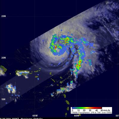
Philippe's Strength Persists

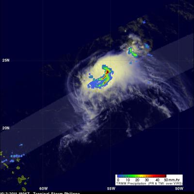
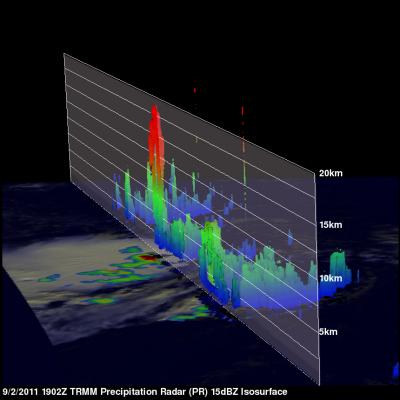
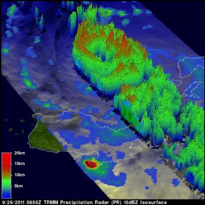
Philippe was still a tropical storm when the TRMM satellite passed above on 3 October 2011 at 1806 UTC (2:06 PM EDT) but the National Hurricane Center (NHC) predicts that the storm may become a hurricane in a couple days. TRMM's TMI and PR data show that bands of powerful convective thunderstorms were still dropping rain at a rate of over 50mm/hr (~2 inches) near the center of the storm.

Tropical Storm Philippe Shows Signs Of Life

Tropical Storm Philippe, located in the central Atlantic Ocean, has shown signs of strengthening. The TRMM satellite obtained those data used in the above image when it passed over on 2 October 2011 at 1902 UTC ( 3:02 PM EDT). TRMM's Microwave Imager (TMI) and Precipitation Radar (PR) derived rainfall showed that Philippe had powerful thunderstorms in the north-central part of the storm dropping rainfall at a rate over 50 mm/hr (~2 inches). TRMM's PR was used in the image below show a vertical cross section (slice) through one of these thunderstorms. This image shows that one of these tall

Nalgae Exits The Philippines and Heads Toward China

The TRMM satellite had a good look at typhoon Nalgae on 2 October 2011 at 0637 UTC after it became the second typhoon in a week to hit the Philippines. Nalgae was in the middle of the South China Sea headed toward southern Hainan. In this image a rainfall analysis from TMI and PR data was overlaid on a combination Infrared and Visible image from TRMM's Visible and InfraRed Scanner (VIRS) instrument. See earlier information about Nalgae

TRMM Sees CAT 4 Ophelia

Ophelia was a very powerful category four hurricane on the Saffir-Simpson scale with winds of over 115 kts (~132 mph) when TRMM passed over head on 2 October 2011 at 0049 UTC. The Infrared image from that orbit shows that Ophelia had a small clear eye as it was passing well to the east of Bermuda. TRMM's Microwave Imager (TMI) and Precipitation Radar (PR) data revealed that heavy rainfall was located in the northern side of the eye wall.

Typhoon Nalgae Menaces the Philippines

The Philippines is still reeling from the devastation caused by typhoon Nesat as another typhoon called Nalgae approaches from the east. Nalgae formed on 27 October 2011 near the same area of the western Pacific Ocean where Nesat originated. The TRMM satellite had a daylight look at Nalgae (known as Quiel in the Philippines) on 30 September 2011 at 0653 UTC. TRMM's Microwave Imager (TMI) and Precipitation Radar (PR) data shows heavy rainfall near Nalgae's eye. The total area of rainfall isn't as extensive as it was with typhoon Nesat at this distance from the Philippines. Click here to see a

Ophelia Becomes a Hurricane

The TRMM satellite saw tropical storm Ophelia on 29 September 2011 at 2008 UTC ( 4:08 PM EDT) shortly before the storm was upgraded to a hurricane by the National Hurricane Center (NHC). An analysis of rainfall from TRMM's Microwave Imager (TMI) and Precipitation Radar (PR) data shows that Ophelia was developing an eye with powerful thunderstorms located in the northwestern side of the forming eye wall. On Friday 30 October 2011 Ophelia further intensified to become a powerful category three hurricane on the Saffir-Simpson scale with winds of 100kts (~115 mph). The NHC has predicted that this

Deadly Typhoon Nesat Hits The Philippines

Powerful typhoon Nesat (known locally as Pedring) came ashore in the Philippines on Tuesday September 27, 2011 causing the deaths of at least 33 people. Nesat was classified as a category three typhoon on the Saffir-Simpson scale with winds of 105 knots (~121 mph) before hitting the island of Luzon. The rainfall analysis above is the result of a TRMM-calibrated merged global Multi-satellite Precipitation Analysis (MPA) performed at Goddard Space Flight Center (GSFC). These MPA rainfall total estimates were for the period from 24-29 September 2011. This analysis indicates that the highest

Ophelia Reviving and Philippe Weakening

The TRMM satellite passed above two tropical cyclones in the Atlantic Ocean early today. Tropical storm Philippe was seen at 0358 UTC (12:58 PM EDT 26 September 2011) and the regenerating remnants of tropical storm Ophelia were observed at 0529 UTC ( 1:29 AM EDT). TRMM's Precipitation Radar (PR) data were used in these images above to show the vertical structure of both storms. The image above used PR data to show that powerful thunderstorm towers were reaching to heights of over 15km (~9.3 miles) in the center of the increasingly better organized Ophelia remnants. Tropical storm Philippe on

Typhoon Nesat Threatens The Philippines

The Philippines have already felt the effects of two typhoons and two tropical storms this year. The TRMM satellite had an excellent early evening view of another typhoon called Nesat on 26 September 2011 at 0856 UTC that is moving toward the Philippines. Typhoon Nesat formed in the Pacific Ocean east of the Philippines 23 September 2011 Nesat is predicted to hit the Philippines within 24 hours as a powerful category two typhoon with wind speeds of about 90 kts (~103.5 mph). The image above shows a rainfall analysis derived from TRMM'S Microwave Imager (TMI) and Precipitation Radar (PR). Those