TRMM News

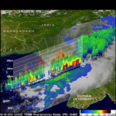
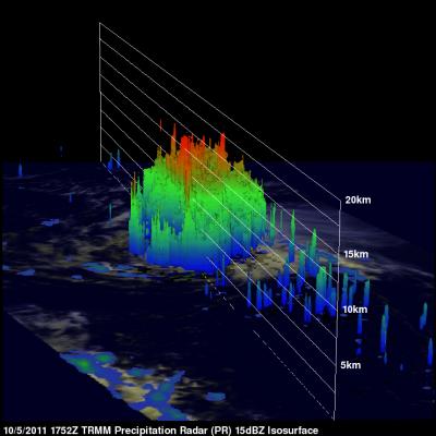
Potential Tropical Cyclone Development In The Caribbean

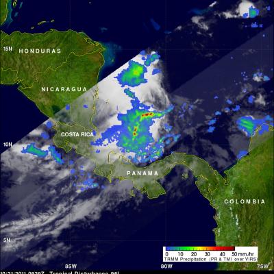
The TRMM satellite passed over an area of disturbed weather in the southern Caribbean Sea between Nicaragua and Jamaica on 21 October 2011 at 0929 UTC. The National Hurricane Center (NHC) has given this area a high chance (60%) of becoming a tropical cyclone over the weekend. Data from TRMM's Precipitation Radar (PR) instrument were used to make the 3-D image above that shows that a cluster of strong convective storms in the southern part of this area were higher than 15 km (~9.3 miles). The heavy rainfall in this area of deep convection releases heat, known as latent heating, into these

TRMM Used to Examine the Bay of Bengal Tropical Cyclone

The accurate measurement of the tropical rainfall around the globe is one of the main objectives of the TRMM satellite. The TRMM satellite has also proven useful for global monitoring of tropical cyclone development. The images above were made from data received by the TRMM satellite when it passed over tropical cyclone 02B in the eastern Bay Of Bengal on 19 October 2011 at 2340 UTC. The image above shows a rainfall analysis that was made from TRMM's Microwave Imager (TMI) and Precipitation Radar (PR) data. It shows that moderate to heavy rainfall associated with 02B was extending

TRMM Views Area Of Possible Tropical Cyclone Development

The TRMM satellite flew over an area of disturbed weather in the southeastern Gulf Of Mexico on 17 October 2011 at 1310 UTC (9:10 AM EDT). The National Hurricane Center (NHC) has given this area of low pressure a medium chance (40%) of becoming a tropical cyclone during the next 48 hours. A rainfall analysis from TRMM's Microwave Imager (TMI) and Precipitation Radar (PR) data shows that a large area of rainfall associated with this disturbance extends from the northern tip of Mexico's Yucatan Peninsula to the southwest coast of Florida. Several stormy areas within this disturbed weather are

Tropical Systems bring Heavy Rain to Mexico and Central America

Within just the past week, the East Pacific has seen a resurgence in tropical activity with the formation of three tropical systems: two hurricanes and a depression. Two of the systems, the two that would go on to become hurricanes, formed on the evening and night of 5 October 2011. The first was TD #10E, the 10th tropical depression of the season in the East Pacific. It formed about 1000 km (~625 mi) south of the Mexican coast and later strengthened into Hurricane Jova. Jova intensified to a Category 3 hurricane before eventually making landfall as a Category 2 storm on Wednesday October 12th

Tropical Depression Banyan

The TRMM satellite collected data on 14 October 2011 at 0837 UTC that were used to make the images above of tropical depression Banyan (known as Ramon in the Philippines). Tropical storm Banyan was the latest killer cyclone to hit the Philippines this year following closely on the heels of typhoons Nesat and Nalgae. Banyan resulted in the reported deaths of at least nine people in the Philippines before weakening and moving into the south china sea as a tropical depression. TRMM satellite data shows that Banyan, although small, contained some powerful convective storm near the center of the

Hurricane Jova Starting to Affect Mexico

The TRMM satellite passed above hurricane Jova off the west coast of Mexico on 11 October 2011 at 1700 UTC. The image above shows a rainfall analysis from TRMM's Microwave Imager (TMI) and Precipitation Radar (PR) overlaid on a combination visible and infrared image from Visible and InfraRed Scanner (VIRS). This TRMM orbit shows that rainfall bands from the powerful category three hurricane were starting drench coastal Mexico.

Tropical Cyclones bring Heavy Rains to the Far East

Over a period of 10 days, a series of three tropical cyclones brought heavy rains and devastating flooding to parts of the Philippines, southern China and Vietnam. The first of these storms to form--and the most devastating--was Typhoon Nesat, which began in the central Philippine Sea. This storm intensified as it tracked westward reaching Category 3 intensity just before making landfall on the northern Philippines island of Luzon early on the morning of the 27th of September. It brought heavy rains and widespread flooding to the region and was initially blamed for 56 fatalities in the

Tropical Storm Jova a Possible Threat to Mexico

Two tropical cyclones called Irwin and Jova have developed in the eastern Pacific southwest of Mexico. The TRMM satellite traveled above tropical storm Jova on 7 October 2011 at 0413 UTC collecting data used in the images above. Jova is predicted to become a hurricane on the morning of 8 October and move northeastward toward the Mexican coast. TRMM's Precipitation Radar (PR) data, shown above, reveals that Jova had a cluster of very powerful thunderstorms near the center of the intensifying storm. Some of these thunderstorms were reaching to heights of over 17 km (~10.6 miles).

Philippe Becomes a Hurricane

The National Hurricane Center (NHC) upgraded Philippe to a hurricane at 1500 UTC (11 AM EDT) on Thursday 6 October 2011. Earlier TRMM Microwave Imager (TMI) data from the 6 October 2011 at 0024 UTC view shows that tropical storm Philippe's center of circulation had become better defined with an eye wall forming. The TRMM satellite also had an excellent look at Philippe earlier on Wednesday 5 October 2011 at 1752 UTC (1:52 PM EDT). TRMM's Precipitation Radar (PR) scanned directly over Philippe and revealed that Philippe had bands of intense rainfall around the southeast side of the center of

Tropical Storm Nalgae Weakens

was a tropical storm and weakening rapidly when the TRMM satellite saw it on 4 October 2011 at 0624 UTC. This rainfall analysis from TRMM's Microwave Imager (TMI) and Precipitation Radar (PR) shows only scattered areas of light to moderate rainfall were present with Nalgae as it moved into the Gulf Of Tonkin west of Hainan. Click here to see earlier TRMM information about Nalgae.