Arabian Sea

Tropical Cyclone Mekunu Examined With GPM Satellite

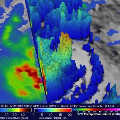
The second tropical cyclone in less than a week has formed in the western Arabian Sea early on May 22, 2018. This tropical cyclone called MEKUNU is intensifying as it heads toward Oman. The Joint Typhoon Warning Center (JTWC) predicts that MEKUNU will have winds of about 85 kts (98 mph) when it hits southwestern Oman in about three days. This will make it the equivalent of a category two hurricane on the Saffir-Simpson hurricane wind scale. Tropical cyclone MEKUNU follows on the heels of destructive and deadly tropical cyclone SAGAR that just made landfall over northwestern Somalia a few days

Yemen Hit by 2nd Tropical Cyclone in a Week

One week ago to the day Cyclone Chapala, the first Category 1 cyclone to strike Yemen in recorded history made landfall on the south-central coast of Yemen, bringing over a year's worth of rain and flooding to that part of the arid country. Today, yet another tropical cyclone, Megh, made landfall in Yemen. Megh, however, made landfall just to the northeast of the coastal city of Aden, which is further west than where Chapala made landfall, and only as a tropical storm. There are, however, several similarities between the two storms. Megh formed in almost the exact same spot in the central

Tropical Cyclone Ashobaa Contains Powerful Storms

The GPM core observatory had another excellent view of tropical cyclone Ashobaa in the Arabian Sea over on June 8, 2015 at 2131 UTC. As expected, Ashobaa was more powerful than when seen by GPM earlier in the day. GPM's Microwave Imager (GMI) and Dual-Frequency Precipitation Radar (DPR) instruments showed that rain was falling at a rate of over 70.5 mm (about 2.8 inches) per hour in bands of storms west of the center of circulation. Very powerful storms were seen west of tropical cyclone Ashobaa's center of circulation by GPM's Ku Band Radar. A 3-D view constructed from GPM's Ku band radar

GPM Flys Over Tropical Cyclone In Arabian Sea

A rare tropical cyclone in the Arabian Sea west of India was seen by the GPM core observatory satellite when it flew over on the morning of June 8, 2015 at 0811Z. Tropical cyclone Ashobaa (TC01A) had sustained wind speeds of about 40 kts (46 mph) when the satellite passed over head. GPM's Microwave Imager (GMI) and Dual-Frequency Precipitation Radar (DPR) instruments measured rain falling at a rate of over 60 mm (2.3 inches) per hour in strong thunderstorms southwest of the storm's center of circulation. A 3-D view was constructed using data from DPR Ku band radar data. This 3-D view of GPM

Arabian Sea Tropical Storm Nanauk

Tropical storm NANUAK formed west of India on June 10, 2014 and since then has been moving toward the northwest over the open waters of the Arabian Sea. The TRMM satellite found that NANAUK contained powerful storms dropping rain at a rate of over 247.3 mm/hr (about 9.7 inches) when viewed on June 11, 2014 at 1549 UTC. An analysis of rainfall from TRMM's Microwave Imager (TMI) and Precipitation Radar (PR) is shown above overlaid on a 1530 UTC enhanced infrared image from the METEOSAT-7 satellite. TRMM PR data were used in the 3-D view shown in the second image. Those data showed that NANAUK

Tropical Storm in the Arabian Sea

Tropical Storm 05A, the 5th of the season in the North Indian Ocean, has been steadily making it's way northwestward across the Arabian Sea over the past few days but is now expected to weaken, reducing the threat to Oman, southern Iran and Pakistan. The storm formed back on November 26th in the North Indian Ocean about 170 km (~105 miles) west of the southern tip of India and has maintained the same minimal tropical storm intensity with sustained winds of around 35 knots (~40 mph) while moving steadily to the northwest into the central Arabian Sea. The Tropical Rainfall Measuring Mission

TRMM Sees Weakening Tropical Storm Keila

The TRMM satellite again flew over tropical storm Keila in the Arabian Sea on November 2, 2011 at 1842 UTC. Data received with that orbit shows that although Keila was weakening it was still producing some very powerful storms off the coast of Oman. A rainfall analysis from TRMM's Microwave Imager (TMI) and Precipitation Radar (PR) indicates that these storms were dropping rain at a rate of over 50mm/hr (~2 inches). TRMM PR data were used in the image above to show the 3-D vertical structure of those storms. Some extremely powerful storms in the band of rainfall off the coast of Oman were

Tropical Storm Keila In The Arabian Sea

The TRMM satellite passed directly above a recently formed tropical cyclone in the Arabian Sea on November 2, 2011 at 0350 UTC. An analysis of rainfall from TRMM's Microwave Imager (TMI) and Precipitation Radar (PR) instruments is shown in the image on the upper left. TRMM data shows that rainfall rates with tropical storm Keila ranged from light to moderate along the south-eastern coast of Oman. Moderate to heavy rainfall was revealed to be spiraling into Keila's center of circulation in the Arabian Sea near the southeastern coast of Oman. The image above is a rendering that shows Keila's