Atlantic Ocean

GPM Sees Heavy Rain In Menacing Hurricane Florence

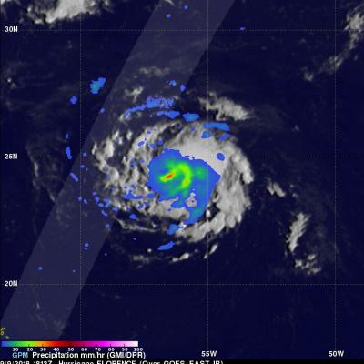
Last Friday Florence was a sheared tropical storm but on Saturday vertical shear lessened and Florence started to get better organized. Today hurricane Florence is rapidly strengthening. The National Hurricane Center (NHC) predicts that Florence will be a major hurricane with maximum sustained winds peaking at 130 kts (~150 mph) on Wednesday when it is over the open Atlantic well southwest of Bermuda. The NHC predicts that Florence's winds will decrease slightly to 125 kts (144 mph) as the hurricane threatens the southeastern United States on Thursday September 13, 2018. OVERPASS 9/9/18: View

Intensifying Atlantic Storm Examined By GPM

On February 8, 2016 at 0800 UTC (3 AM EST) the GPM core observatory satellite flew above an intensifying storm in the Atlantic Ocean off the United State's East Coast. This storm is forecast by the National Weather Service (NWS) to bring strong winds, heavy rainfall, and coastal flooding to the Carolina's. Although the center of the storm is well off the coast, bands of precipitation from the storm are also expected to bring heavy snow to eastern New England. A rainfall analysis derived from data collected by GPM's Microwave Imager (GMI) and Dual-frequency Precipitation Radar (DPR) instruments

Hurricane Edouard Headed for Cooler Waters

Edouard, which became the fifth named storm of the season after forming on the night of September 11th (EDT) west of the Cape Verde Islands, continued to strengthen as it made its way through the central Atlantic this past week, reaching hurricane intensity on the 14th before becoming the first major hurricane of the season when it peaked briefly as a category 3 storm on the 16th with sustained winds reported at 100 knots (~115 mph) by the National Hurricane Center (NHC). Fortunately, the storm has not posed a threat to the US East Coast due to the presence of a deep-layer trough along the

Tropical Storm Edouard forms in the Atlantic

The formation of Tropical Storm Edouard in the central Atlantic marks the climatological peak of the Atlantic hurricane season in what has so far been a rather average season in terms of the number of storms. Edouard became the fifth named storm of the season after forming overnight in the central Atlantic about 1645 km (~1020 miles) west of the Cape Verde Islands. In a typical season there are about 10 named storms and 6 hurricanes. So far this year, halfway through the season, there have been 5 named storms and 3 hurricanes, but none have posed a major threat to the US, and there have been

Boris Dissipates, Atlantic Disturbance Stengthens

On June 5, 2014 at 0549 UTC (1:49 AM EDT) the TRMM satellite flew above the remnants of tropical Depression Boris and powerful thunderstorms that recently developed in the Gulf of Mexico. Rainfall derived from TRMM Microwave Imager (TMI) and Precipitation Radar (PR) data are shown overlaid on an enhanced infrared image from the GOES-EAST satellite. TRMM found heavy rainfall over Mexico's Pacific coast and with a disturbance in the Gulf Of Mexico (90L). Rainfall was falling at the extreme rate of over 163 mm (about 6.4 inches) per hour in powerful thunderstorms associated with the low pressure

Morning View of Tropical Storm Melissa

The TRMM satellite passed directly above tropical storm Melissa's center of circulation on November 20, 2013 at 1121 UTC (6:21 EST). TRMM's Precipitation Radar (PR) instrument found that rain was falling at a maximum rate of 55 mm/hr (~2.2 inches) in an area just to the southeast of Melissa's center of circulation. TRMM Precipitation Radar data were also used in the image on the right to show Melissa's 3-D structure. The tallest towers, reaching heights of over 13km (~8 km), were located in a band of rainfall to the northwest of Melissa's center. The strongest intensity radar echo of over

TRMM Sees First Atlantic Tropical Storm Forming

The TRMM satellite flew above tropical storm Alberto when it was forming off the coast of South Carolina today. TRMM Microwave Imager (TMI) and Precipitation Radar (PR) data captured at (12 minutes after midnight EDT) were used in the rainfall analysis shown above. It shows a large area of moderate to heavy rainfall with a small area of heavy rainfall located near the center of the forming tropical cyclone.

Tropical Storm Philippe Shows Signs Of Life

Tropical Storm Philippe, located in the central Atlantic Ocean, has shown signs of strengthening. The TRMM satellite obtained those data used in the above image when it passed over on 2 October 2011 at 1902 UTC ( 3:02 PM EDT). TRMM's Microwave Imager (TMI) and Precipitation Radar (PR) derived rainfall showed that Philippe had powerful thunderstorms in the north-central part of the storm dropping rainfall at a rate over 50 mm/hr (~2 inches). TRMM's PR was used in the image below show a vertical cross section (slice) through one of these thunderstorms. This image shows that one of these tall

Tropical Storm Ophelia Forms

The TRMM satellite passed over newly formed tropical storm Ophelia in the Atlantic Ocean on September 2011 at 0752 UTC ( 4:52 AM EDT). TRMM shows that Ophelia isn't very well organized and contains only a few scattered areas of heavy rainfall. The National Hurricane Center (NHC) has predicted that Ophelia will remain a tropical storm with wind speeds reaching a maximum of 50 kts (~58 mph).

Tropical Storm Katia Takes Shape in the Atlantic

While parts of the East Coast and New England are still recovering from Hurricane Irene, a new storm is brewing in the Atlantic, Tropical Storm Katia. Katia began as an area of low pressure that had moved away from the coast of Africa south of the Cape Verde Islands in the central eastern Atlantic. This area of low pressure became the twelfth tropical depression of the season (TD #12) early on the morning of August 29th about 640 km (~400 miles) south-southwest of the Cape Verde Islands and about 1400 km (~870 miles) off the coast of Africa. Storms forming in this region are known as "Cape