Florida

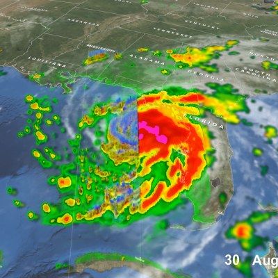
GPM Overpass of Hurricane Idalia
After threatening much of Florida’s western coast, Hurricane Idalia made landfall Wednesday morning in the Big Bend region of Florida’s northwest coast near Keaton Beach at 7:45 a.m. EDT, Aug. 30, as a strong Category 3 storm with sustained winds reported at 125 mph by the National Hurricane Center. Idalia’s formation was somewhat unusual. Typically, when entering the heart of the hurricane season tropical storms and hurricanes form and expand eastward across the tropical Atlantic region towards Africa’s coast. However, storms occasionally still form in the western Caribbean, as was the case
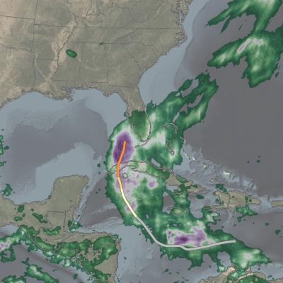
IMERG analysis of Hurricane Ian
On Sept. 30, 2022, Hurricane Ian was approaching South Carolina, which was one day after Ian finished its west-to-east crossing of Florida. NASA has been estimating Hurricane Ian's precipitation over land and ocean, which complements the array of detailed observations collected by NOAA and other agencies of Ian's impact over land.
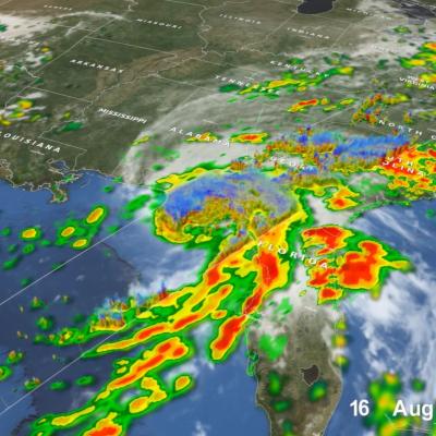
GPM Overpass of Tropical Cyclone Fred on August 16, 2021.
Tropical Storm Fred, the 6th named storm of the 2021 Atlantic hurricane season, began as a westward moving disturbance in the central Atlantic east of the Lesser Antilles. The system passed through the southern Leeward Islands during the early morning hours of August 10 but still lacked a well-defined center of circulation. Despite significant thunderstorm activity within the system, it wasn’t until late that evening, when the system was passing just south of Puerto Rico, that the National Hurricane Center (NHC) identified a well-defined circulation and upgraded the system to Tropical Storm
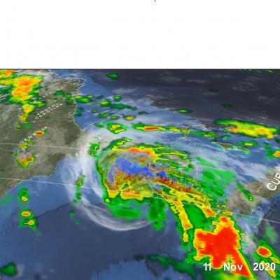
GPM Overpass of Hurricane Eta Nov. 11 2020
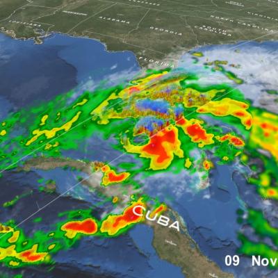
After a long and meandering journey over Central America, across central Cuba, and through the Florida Keys, Eta, the 28th named storm and 12th hurricane of the 2020 Atlantic hurricane season, wound up nearly stationary as a moderate tropical storm in the southeastern Gulf of Mexico just north of the western tip of Cuba on the morning of November 10th. Before long however, a deep layer trough located over the western third of the US began to shift eastward, and by the afternoon of the 10th, it started to pull Eta back towards the north and the west coast of the Florida peninsula. As it did so
Hurricane Eta over Florida
After striking the northeast coast of Nicaragua as a powerful Category 4 storm back on November 3, Hurricane Eta weakened rapidly over Central America but still brought major flooding and triggered numerous landslides that so far have resulted in at least 250 fatalities across the region, according to media reports. Eta was down to a tropical depression when the center re-emerged over the northwestern Caribbean on the evening of November 5. An upper-level trough over the Gulf of Mexico first steered Eta northeastward towards Cuba on the 6th. Because it was disorganized after its trek across

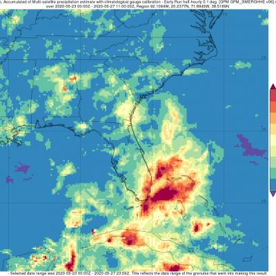
Short-lived Bertha Brings Heavy Rains to Parts of Florida

Bertha was a named storm for just the briefest of periods, becoming a tropical storm on the morning of Wednesday May 27th at 8:30 am EDT just one hour before it made landfall along the South Carolina coast near Charleston. After making landfall, Bertha quickly weakened into a tropical depression and was then accelerated northward by the southerly flow between a deep trough of low pressure over the Mississippi Valley to the west and a ridge of high pressure located just off the US East Coast. Because of this, rainfall totals over the Carolina’s were not very heavy. Bertha’s biggest impact actually occurred when it was still in the formation process, before it became organized enough to be named. On Monday May 25th, a trough of low pressure became established over the Florida Straits, initiating shower and thunderstorm activity in the region. Over the next day, as this trough, which extended eastward over the warm waters of the Gulf Stream and eventually led to Bertha, slowly moved northward up the Florida peninsula, it provided a focus for showers and thunderstorms, which brought heavy rains to southeast Florida.
GPM observes Hurricane Dorian lashing Florida
Download in high resolution from the NASA Goddard Scientific Visualization Studio GPM captured Dorian at 10:41 UTC (6:41 am EDT) on the 4th of September when the storm was moving north-northwest parallel to the coast of Florida about 90 miles due east of Daytona Beach. Three days earlier, Dorian had struck the northern Bahamas as one of the most powerful Category 5 hurricanes on record in the Atlantic with sustained winds of 185 mph. Weakening steering currents allowed the powerful storm to ravage the northern Bahamas for 2 full days. During this time, Dorian began to weaken due to its...
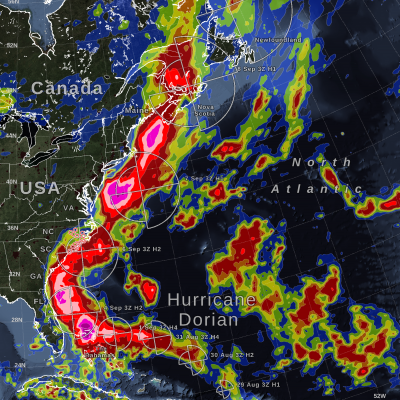
IMERG Measures Rainfall in Hurricane Dorian
UPDATE 9/9/19: On Monday morning, September 9, Hurricane Dorian was a post-tropical storm after a mid-latitude weather front and cold seas had altered its tropical characteristics over the weekend. On Saturday and Sunday, Hurricane Dorian struck eastern Canada, causing wind damage and bringing heavy rainfall. According to the Associated Press, a peak of 400,000 people were without power in Nova Scotia, Canada, because of Dorian. This graphic shows precipitation that fell during the almost two-week period from August 27 to the early hours of September 9. The near-realtime rain estimates come...
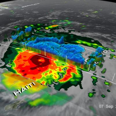
GPM Examines Hurricane Irma
The GPM core observatory satellite had an exceptional view of hurricane Irma's eye when it flew above it on September 5, 2017 at 12:52 PM AST (1652 UTC). This visualization shows a rainfall analysis that was derived from GPM's Microwave Imager (GMI) and Dual-Frequency Precipitation Radar (DPR) data. Irma was approaching the Leeward Islands with maximum sustained winds of about 178 mph (155 kts). This made Irma a dangerous category five hurricane on the Saffir-Simpson hurricane wind scale. Intense rainfall is shown within Irma's nearly circular eye. This 3-D cross-section through Irma's eye was...

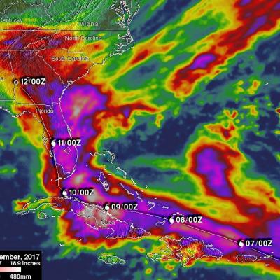
Irma’s Heavy Rainfall Measured With GPM IMERG

Hurricane Irma dropped extremely heavy rain at times during it’s trek from near the Cape Verdi Islands through the northern Leeward islands, Cuba and the southeastern United States. Over 16 inches (406 mm) of rain was reported in Guantanamo, in the easternmost province of Cuba, as the category five hurricane battered the country. Almost 16 inches (406 mm) of rain was also reported at Fort Pierce on the eastern side of Florida. Charleston, South Carolina reported 6 inches (152.4 mm) of rain in 24 hour. This heavy rainfall plus storm surge flooding caused the worst flooding in Charleston since