Gulf of Mexico

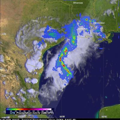
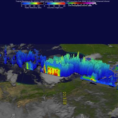
GPM Sees Developing Tropical Storm Barry in the Gulf of Mexico

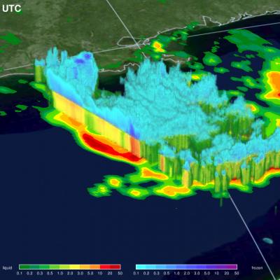
NASA / JAXA’s GPM Core Observatory passed over developing Tropical Depression 2 (which was upgraded to Tropical Storm Barry later in the morning) in the Gulf of Mexico the morning of July 11th 2019 at 8:26am CT, capturing estimates of rainfall rates within the storm. The first image shows rainfall rates collected by GPM’s Microwave Imager, while the second image shows 3D rainfall rates within the atmospheric column from GPM’s Dual-frequency Precipitation Radar (DPR). The DPR measured storm top heights as high as 18 km, which is extremely high and indicative of intense thunderstorm activity

GPM Satellite Probes Storms In The Western Gulf Of Mexico

A mid-level and surface trough over southern Texas is producing heavy rainfall. Heavy rainfall is expected to continue in the area through Wednesday evening. On June 19, 2018 at 3:37 PM CDT ( 2037 UTC) the GPM core observatory satellite passed over the western Gulf Of Mexico. This GPM pass revealed extreme rainfall that was being produced by a tropical disturbance in the northwestern Gulf Of Mexico. GPM's Microwave Imager (GMI) and Dual Frequency Precipitation Radar (DPR) instruments probed powerful storms that were dropping rain at a rate of 3.5 inches (88 mm) per hour. The GPM satellite's

GPM Sees Potential Tropical Depression Developing In The Gulf Of Mexico

The GPM Core Observatory satellite had an excellent view of a potential tropical depression developing in the Gulf Of Mexico on September 5, 2017 at 3:34 AM CDT (0834 UTC). GPM found that powerful convective storms were dropping heavy rainfall in the Gulf of Mexico east Mexico's coast. GPM's Dual-Frequency Precipitation Radar (DPR) instrument measured rain falling at a rate of over 9.2 inches (233 mm) per hour in an intense band of storms. GPM's Radar (DPR Ku Band) data was used to examine the 3-D structure of precipitation in this area of strong convective storms. GPM's DPR showed that storm

Tropical Storm Debby Threatens Florida Gulf Coast

Tropical Storm Debby formed on the 23rd of June 2012 in the central Gulf of Mexico, becoming the earliest 4th named storm on record. Debby began as an area of low pressure that moved out of the northwestern Caribbean and into the Gulf. After forming on the afternoon of the 23rd, Debby has moved very slowly under the influence of weak steering currents. Debby drifted ever so slowly northward on the night of the 23rd before turning northeast later on the morning of the 24th towards the northeast Gulf Coast of Florida. Despite its slow forward progress and lack of intensification, Debby has

TRMM Sees Flooding Rainfall Along Gulf

The states along the coast of the Gulf of Mexico experienced very heavy rainfall on Saturday June 9,2012 and Sunday June 10, 2012. The images above use TRMM satellite data collected when it flew over on Sunday June 10, 2012. Unusually heavy rainfall was occurring in states near the Gulf coast. Due to the path of TRMM's orbits it had good coverage with more than one orbit. The first orbit occurred at 1501 UTC (11:01 AM EDT). The second image shows a combination of more than one orbit with the later data being collected at about 1817 UTC (2:17 PM EDT). TRMM rainfall analyses from these orbits

Extreme Rainfall from Tropical Storm Lee

The rainfall analysis above is from TRMM calibrated precipitation estimates called Multi-satellite Precipitation Analysis (MPA). This product was developed by the precipitation research team in the Laboratory for Atmospheres at NASA Goddard Space Flight Center and uses satellite data collected in "real time"(3B42 ). This preliminary analysis shows the estimated total rainfall measured for the period from 30 August to 6 September 2011 and includes rainfall from other sources including tropical storm Lee. Tropical storm Lee has been dropping heavy rain since moving over land from the Gulf Of

TRMM Sees TD13 Forming

The TRMM satellite viewed the thirteenth tropical depression of the Atlantic hurricane season on Thursday 1 September 2011 at 1309 UTC (9:09 AM EDT) when it was still forming. The National Hurricane Center (NHC) has predicted that TD13 will intensify and become a tropical storm (Lee) today. The tropical storm is predicted by the NHC to slowly move toward the northwest and cause heavy rainfall over the states along the northern Gulf Of Mexico's coast. One area of heavy rainfall in the middle of the Gulf Of Mexico was in the center of the area viewed by TRMM's Precipitation Radar (PR). Some of

Tropical Storm Don Forms In The Gulf Of Mexico

An area of disturbed weather in the southern Gulf Of Mexico was upgraded by the National Hurricane Center (NHC) to tropical storm DON on 27 July 2011 at 2100 UTC (4 PM CDT). The TRMM satellite had a fairly good view of tropical Storm DON when it passed over on 28 July 2011 at 0609 UTC (2:09 AM EDT). A red tropical storm symbol shows the position, north of Mexico's Yucatan peninsula, where DON was located at that time. A rainfall analysis from TRMM's Microwave Imager (TMI) data shows that DON was dropping moderate to heavy rainfall in the eastern side of the small storm. The NHC predicts that