heavy rainfall

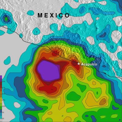
Norbert & Dolly Rain On Both Mexican Coasts

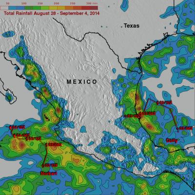
Tropical storm Dolly dissipated quickly after coming ashore yesterday in eastern Mexico but dropped heavy rain in some areas near the Gulf coast. At the same time tropical storm Norbert was approaching from the west and contributing to rainfall near Mexico's Pacific coast. TRMM-based, near-real time Multi-satellite Precipitation Analysis (MPA) data for the period from August 28 to September 4, 2014 were used in the analysis shown above. The approximate past locations of the tropical cyclones at 0000Z and 1200Z are shown overlaid in red on this analysis. The heaviest rainfall totals were found

Super Typhoon Rammasun Strikes the Southern Coast of China

Super typhoon Rammasun struck the southern coast of China on Friday July 18th as a very powerful super typhoon with sustained winds estimated at 135 knots (~155 mph or equivalent to a Category 5 hurricane on the US Saffir-Simpson scale), making it the strongest typhoon to hit the area in several decades. Rammasun made landfall at 3:30 pm (local time) on Hainan Island where the southern half of the intense eye wall raked across the northeast tip of that island. The center then quickly cut across the Qiongzhou Strait separating Hainan from the Leizhou Peninsula to the north. The right half of

Heavy Rainfall For Mexico & Central America

The movement of tropical storm Boris into southern Mexico and a nearly stationary low pressure system in the southern Gulf Of Mexico has been causing heavy rainfall in that area. The TRMM-based, near-real time Multi-satellite Precipitation Analysis (TMPA) at the NASA Goddard Space Flight Center monitors rainfall over the global Tropics. TMPA rainfall totals are shown here for the period May 29 to June 6, 2014. The highest rainfall totals of over 535 mm were analyzed where tropical storm Boris came ashore in southern Mexico. The slow moving low pressure center in the Bay Of Campeche is

A Week of Heavy Rainfall With Stormy Weather

During the past week many areas of the United States from Kansas to the Atlantic seaboard have been hit by heavy rainfall. Flash floods have created hazards in several areas from Texas to Washington, DC. Some parts of Texas got more rain in two days than received in the past year. Tornadoes were reported in some part of the United States every day of the past week except Tuesday from May 9-16, 2014. The TRMM Multi-Satellite Precipitation Analysis (TMPA), produced at Goddard Space Flight Center, combines the rainfall estimates generated by TRMM and other satellites (3B42). The analysis above
Tropical Cyclone Ita Drenches Australia JacobAdmin Mon, 04/14/2014
After coming ashore this past Friday tropical cyclone ITA dropped heavy rainfall over the weekend that caused flooding in many areas of northeastern Australia's state of Queensland. IDA has now moved back into the Coral Sea. The analysis above shows a TRMM-based near-real time Multi-satellite Precipitation Analysis (TMPA) made at the NASA Goddard Space Flight Center. This analysis used TMPA precipitation data from April 1-14, 2014 during the period when ITA formed in the Coral Sea and moved along northeastern Australia's coast. IDA's locations at 0600 UTC are shown overlaid in white. The

Hurricane Raymond's Copious Rainfall Analyzed

Powerful hurricane Raymond, located off Mexico's south-central Pacific coast, has weakened to a tropical storm. It has now started to move slowly away from the location where it has been parked since Monday October 21, 2013. Raymond dropped abundant rainfall in much of the same area already hit by deadly flooding and landslides with Hurricane Manuel last month. The rainfall analysis above was made at Goddard Space Flight Center using TRMM-based, near-real time Multi-satellite Precipitation data (TMPA) collected during the period from October 15 to 23, 2013. Rainfall totals greater than 125mm (

Extreme India Monsoon Rainfall Analyzed

Extreme, sometimes disastrous, monsoon rainfall has occurred so far over India during June and July 2013. The image above shows rainfall total estimates from space satellite data for the seven day period ending on June 17, 2013. Near real-time TRMM Merged HQ/Infrared Precipitation (3B42) data, with seven days totals, were analyzed for the period from June 14-July 25, 2013. These rainfall estimates are shown in simulated 3-D perspective views with higher precipitation amounts appearing to be taller than lower amounts. Rainfall totals were also color enhanced with lower amounts being assigned

Tropical Storm Debby Drenches Florida

Even though it never became more than a tropical storm, the residents of northern and central Florida will remember Debby. Debby, which formed as a tropical storm on the 23rd of June 2012 in the central Gulf of Mexico, took three full days to reach the Big Bend of Florida just 350 miles away. Although the center didn't make landfall until around 5 pm on the afternoon of the 26th when it crossed the coast near Steinhatchee, Florida, Debby's effects were felt well away from the center. Most of the rain and weather associated with Debby were well to the north and east of the center over Florida

Strong Storms Bring Heavy Rain, Flooding to Upper Midwest

An upper-level trough of low-pressure dropping down out of the Canadian Rockies in combination with a persistent frontal boundary and high pressure over the Southeast, combined to bring about strong storms and flooding over the Upper Midwest. The storms brought the worst flooding on record to Duluth, Minnesota where as much as 10 inches of rain were reported over a 2-day period from 19th to the 20th of June, resulting in flash flooding and many washed out roads. Even the zoo was flooded. Washed out roads were blamed for 3 fatalities in nearby Wisconsin. Counter-clockwise flow around high

TRMM Sees Flooding Rainfall Along Gulf

The states along the coast of the Gulf of Mexico experienced very heavy rainfall on Saturday June 9,2012 and Sunday June 10, 2012. The images above use TRMM satellite data collected when it flew over on Sunday June 10, 2012. Unusually heavy rainfall was occurring in states near the Gulf coast. Due to the path of TRMM's orbits it had good coverage with more than one orbit. The first orbit occurred at 1501 UTC (11:01 AM EDT). The second image shows a combination of more than one orbit with the later data being collected at about 1817 UTC (2:17 PM EDT). TRMM rainfall analyses from these orbits