Weaker Hurricane Humberto
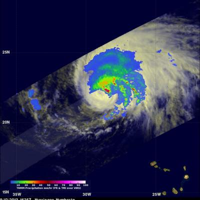
Southwesterly wind shear has taken it's toll on hurricane Humberto. An eye was no longer distinct in data collected when the TRMM satellite passed over on September 12, 2013 at 1625 UTC (12:25 PM EDT). An analysis derived from TRMM Microwave Imager (TMI) and Precipitation Radar (PR) data shows that most of the precipitation with Humberto was then located in the northwestern quadrant. TRMM found that the most intense rain was falling at a rate of over 99mm/hr (~3.9 inches) at 22.4 North 28.7 West near Humberto's center. TRMM PR also found that the highest storm towers were reaching heights of