Maria

Dive Into a 360-View of Hurricane Maria
Two days before Hurricane Maria devastated Puerto Rico, the NASA/JAXA Global Precipitation Measurement Core Observatory satellite captured a 3D view of the 2017 storm. At the time Maria was a category 1 hurricane. The 3-D view reveals the processes inside the hurricane that would fuel the storm’s intensification to a category 5 storm within 24 hours. For the first time in 360 degrees, this data visualization takes you inside the hurricane. The precipitation satellite has an advanced radar that measures both liquid and frozen water. The brightly colored dots show areas of rainfall, where green...

Typhoon Maria Makes Landfall

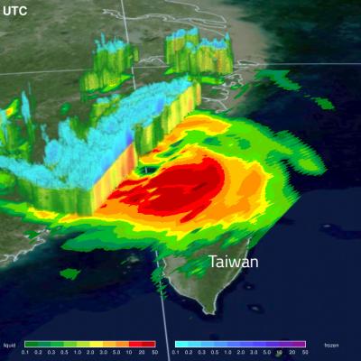
After striking the Ryukyu Islands of Japan and grazing Taiwan with torrential rains, Typhoon Maria made landfall just north of the populous city of Fuzhou, China with sustained winds of 95 knots and a broad shield of precipitation. The storm appears lopsided in the GMI, with much of the deep convection offshore, however, it is still likely to bring a brief period of flooding rains to this part of China before dissipating. View fullscreen in STORM Event Viewer

GPM Views Super Typhoon Maria Near Guam

View full screen in STORM Event Viewer. Rapidly intensifying after its genesis near Guam, Super Typhoon Maria featured winds near 130 knots as it spiraled through the waters of the Western Pacific Ocean. The DPR scan indicates deep convection in several parts of the outer bands, with the most intense precipitation rates from GMI concentrated in the eyewall. Maria is expected to continue intensifying over the next three days, then weaken slightly as it crosses through the Ryukyu Islands, possible near Okinawa. The long range forecast has it making landfall in Northern China, possibly still as a
Intense Hurricanes Seen From Space
In 2017, we have seen four Atlantic storms rapidly intensify with three of those storms - Hurricane Harvey, Irma and Maria - making landfall. When hurricanes intensify a large amount in a short period, scientists call this process rapid intensification. This is the hardest aspect of a storm to forecast and it can be most critical to people's lives. While any hurricane can threaten lives and cause damage with storm surges, floods, and extreme winds, a rapidly intensifying hurricane can greatly increase these risks while giving populations limited time to prepare and evacuate.

GPM Views Weakening Hurricane Maria

Hurricane Maria has significantly weakened from the powerful category four hurricane that devastated Puerto Rico. The GPM core observatory satellite flew over Maria on September 25, 2017 at 9:28 PM EDT (September 26, 2017 at 0128 UTC). This informative GPM pass showed that the western side of the hurricane was drier and contained much less precipitation than the eastern side. GPM's Dual-Frequency Precipitation Radar (DPR) scanned directly through the center of Maria's eye and showed that there were only light to moderate rain showers around the hurricane's center. DPR found a few convective

GPM Shows Hurricane Maria North Of Turks And Caicos Islands

On September 23, 2017 at 8:12 AM AST (1212 UTC) the GPM core observatory satellite had another excellent view of hurricane Maria. The early morning view showed Maria heading north of the Bahamas after battering the Turks and Caicos Islands. Maria had maximum sustained wind speeds of about 121mph (105 kts). Estimates of hourly rainfall at the ocean's surface were derived from GPM's Microwave Imager (GMI) and Dual-Frequency Precipitation Radar (DPR) data. Multiple intense rainfall bands are shown rotating around the western side of the hurricane. Rain was found falling at a rate of over 6.57

Hurricane Maria's Torrential Rainfall Measured By IMERG

Hurricane Maria has caused catastrophic flooding in Puerto Rico. Extreme flooding was reported in the streets of San Juan, the capital of Puerto Rico. The National Weather Service issued flash flood warnings for the entire island. Hurricane Maria has now moved to the northwest of Puerto Rico but is still expected to contribute to rainfall over the island on Friday. Feeder bands are transporting rain over Puerto Rico and the Dominican Republic even as the hurricane moves toward the Turks and Caicos islands. NASA's Integrated Multi-satellitE Retrievals for GPM (IMERG) data were used to estimate
GPM Sees Hurricanes Maria and Jose
GPM passed over both Hurricane Maria and Hurricane Jose on September 18th, 2017. As the camera moves in on the Maria, DPR's volumetric view of the storm is revealed. A slicing plane moves across the volume to display precipitation rates throughout the storm. Shades of green to red represent liquid precipitation extending down to the ground. The Global Precipitation Measurement (GPM) mission shows the rainfall distribution for two major storms churning in the Atlantic and Caribbean basins. The visualization shows Hurricane Jose as it continues to slowly move northward off the US East Coast east...

GPM Satellite Looks At Hurricane Maria's Rainfall

Early this morning (after 6 AM local time) hurricane Maria made landfall near Yabucoa, Puerto Rico as a strong category four hurricane. Maximum sustained winds in the hurricane were reported to be 149.5 mph (130 kts) as Maria moved toward San Juan, Puerto Rico. Powerful convective storms within the hurricane were also dropping heavy rainfall. The GPM core observatory satellite collected data as it passed above hurricane Maria earlier on September 19, 2017 at 9:51 PM AST (September 20, 2017 0151 UTC). This rainfall analysis was derived from GPM's Microwave Imager (GMI) and Dual-Frequency