Powerful Hurricane Lane Probed By GPM Satellite
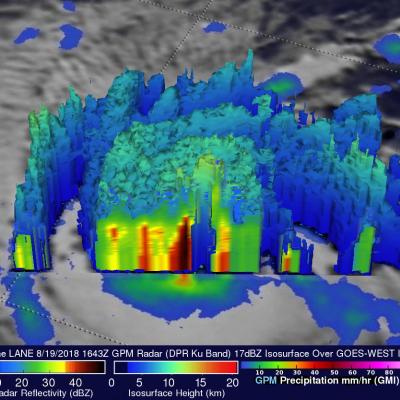
Hurricane LANE had moved westward into the central Pacific Ocean far southeast of the Hawaiian islands when the GPM core observatory satellite passed above on August 19, 2018 at 1643 UTC. LANE had intensified and had maximum sustained winds reaching about 105 kts (~ 121 mph) at that time. This made it a category three on the Saffir-Simpson hurricane wind scale. The GPM satellite's Microwave Imager (GMI) and Dual-Frequency Precipitation Radar (DPR) instruments provided highly accurate information about precipitation within the hurricane. GPM's GMI revealed rainfall coverage and GPM's radar (DPR