Philippines

Typhoon Nalgae Menaces the Philippines

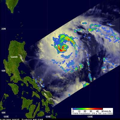
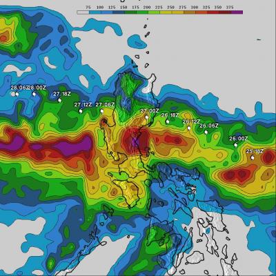
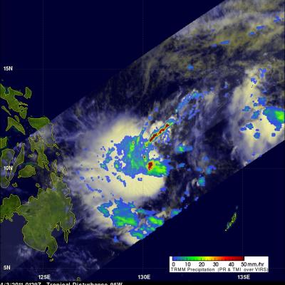
The Philippines is still reeling from the devastation caused by typhoon Nesat as another typhoon called Nalgae approaches from the east. Nalgae formed on 27 October 2011 near the same area of the western Pacific Ocean where Nesat originated. The TRMM satellite had a daylight look at Nalgae (known as Quiel in the Philippines) on 30 September 2011 at 0653 UTC. TRMM's Microwave Imager (TMI) and Precipitation Radar (PR) data shows heavy rainfall near Nalgae's eye. The total area of rainfall isn't as extensive as it was with typhoon Nesat at this distance from the Philippines. Click here to see a

Deadly Typhoon Nesat Hits The Philippines

Powerful typhoon Nesat (known locally as Pedring) came ashore in the Philippines on Tuesday September 27, 2011 causing the deaths of at least 33 people. Nesat was classified as a category three typhoon on the Saffir-Simpson scale with winds of 105 knots (~121 mph) before hitting the island of Luzon. The rainfall analysis above is the result of a TRMM-calibrated merged global Multi-satellite Precipitation Analysis (MPA) performed at Goddard Space Flight Center (GSFC). These MPA rainfall total estimates were for the period from 24-29 September 2011. This analysis indicates that the highest

Typhoon Nesat Threatens The Philippines

The Philippines have already felt the effects of two typhoons and two tropical storms this year. The TRMM satellite had an excellent early evening view of another typhoon called Nesat on 26 September 2011 at 0856 UTC that is moving toward the Philippines. Typhoon Nesat formed in the Pacific Ocean east of the Philippines 23 September 2011 Nesat is predicted to hit the Philippines within 24 hours as a powerful category two typhoon with wind speeds of about 90 kts (~103.5 mph). The image above shows a rainfall analysis derived from TRMM'S Microwave Imager (TMI) and Precipitation Radar (PR). Those

Another Tropical Cyclone Develops Near The Philippines

The sixth western Pacific tropical cyclone (06W) of 2011 has developed near the Philippines. Tropical storm AERE, super syphoon SONGDA and Tropical Storm SARIKA have already affected the Philippines this year. The TRMM satellite had an early morning look at the forming depression on 16 June 2011 at 2130 UTC. A precipitation analysis from TRMM's Microwave Imager (TMI) and Precipitation Radar (PR) shows that 06W wasn't well organized but contained areas of moderate to heavy rainfall located east of the Philippines. 06W is expected to intensify to a tropical storm, brush the northeastern coast of

TRMM Sees Typhoon Songda

Typhoon Songda was east of the Philippines when the TRMM satellite had an early evening view on 25 May 2011 at 0903 UTC. Both TRMM's Microwave Imager (TMI) and Precipitation Radar (PR) instruments were used to provide the rainfall analysis shown above. TRMM's TMI had the best coverage of rainfall with Songda and showed well organized bands of moderate to heavy rainfall converging into the typhoon. Songda was an intensifying category 3 typhoon, on the Saffir-Simpson scale, with wind speeds of over 105 kts (~121 mph) at that time. Songda is predicted to become a very powerful category 4 super