Thunderstorms

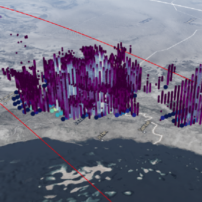
GPM Radar Views Powerful Convective Storms over Saudi Arabia

V iew full-screen in STORM Event Viewer Saudi Arabia is not thought of as a region rife with intense thunderstorms, but its southwestern region features an abrupt orographic incline from the Red Sea coast toward the interior. Here, warm moist air can be forceably lifted up the slope of the Sarawat Mountains resulting in torrential downpours and flash flooding. In this overflight, we see an occasion of this, with DPR cloud top heights up to 20km and 89 GHz brightness temperatures near 55K, suggesting the likelihood of hail within the deep convective plume.

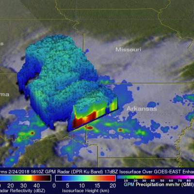
Severe Midwest Storms Probed By GPM Satellite

The GPM core observatory satellite flew over stormy weather in the Midwest on Saturday February 24, 2018 at 1610 UTC (10:10 AM CST). Floods and very severe thunderstorms were developing with this slow moving storm complex. Later in the day tornadoes within these storms caused destruction and injuries in the states of Kentucky, Arkansas, Missouri and Tennessee. Tornadoes and flooding were blamed for at least four fatalities. Kentucky was particularly hard hit with Saturday evening tornadoes moving through southwestern Kentucky causing multiple injuries and at least three deaths. GPM's microwave

Severe Weather In Tornado Alley And Eastward (May 2nd Update)

Severe spring thunderstorms frequently spawned tornadoes from the Gulf Coast north and eastward during the past seven days. From April 25 to May 2, 2016 there were over 67 tornadoes in the United States reported to the National Oceanic and Atmospheric Administration (NOAA). Many of these tornadoes were located in an area that includes the states of Texas, Oklahoma, Kansas, and Nebraska. This area of the Great Plains has been labeled Tornado Alley due to the many tornadoes that occur there this time of year. Gulf moisture clashing with frontal systems moving over the United States provided much

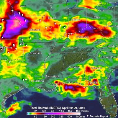
Severe Weather In Tornado Alley And Eastward

Severe spring thunderstorms frequently spawned tornadoes from the Gulf Coast north and eastward during the past week. Gulf moisture clashing with frontal systems moving over the United States provided much of the fuel for intense showers and severe thunderstorms. Flash flooding was often the result of the sudden onset of extremely heavy rainfall. Over 305 mm (12 inches) of rain was reported in southern Mississippi in a few hours one morning on April 28, 2016. NASA's Integrated Multi-satellitE Retrievals for GPM (IMERG) data were used to estimate the amount of rain that fell from April 22-29

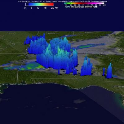
GPM Satellite Examines Tornadic Thunderstorms

Over the past few days tornado spawning thunderstorms have occurred in the states of Texas, Oklahoma, Arkansas, Louisiana, Indiana, Mississippi, Alabama and Georgia. Large hail, damaging winds, and flash flooding associated with a frontal system moving across the United States have compounded the damage from these storms. Hail the size of a half-dollar was reported near Jackson, Louisiana on Thursday evening. The GPM core observatory satellite flew over this stormy area on April 1, 2016 at 0241 UTC (March 31, 2016 at 10:41 PM EDT). Tornadoes were reported in Mississippi, Alabama and Georgia

Why Do Raindrop Sizes Matter In Storms?

Submitted by JacobAdmin on Thu, 03/31/2016
Video Embed

Not all raindrops are created equal. The size of falling raindrops depends on several factors, including where the cloud producing the drops is located on the globe and where the drops originate in the cloud. For the first time, scientists have three-dimensional snapshots of raindrops and snowflakes around the world from space, thanks to the joint NASA and Japan Aerospace Exploration Agency Global Precipitation Measurement (GPM) mission.

Measures Raindrop Sizes From Space
Not all raindrops are created equal. The size of falling raindrops depends on several factors, including where the cloud producing the drops is located on the globe and where the drops originate in the cloud. For the first time, scientists have three-dimensional snapshots of raindrops and snowflakes around the world from space, thanks to the joint NASA and Japan Aerospace Exploration Agency Global Precipitation Measurement (GPM) mission. With the new global data on raindrop and snowflake sizes this mission provides, scientists can improve rainfall estimates from satellite data and in numerical...

GPM Examines Violent Thunderstorms in U.S.

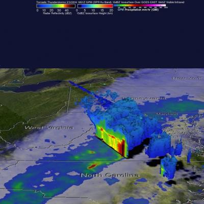
Severe weather moved through the southern U.S. on February 2 and 3, and NASA's Global Precipitation Measurement or GPM core satellite examined the violent thunderstorms. On February 3, 2016 at 1851 UTC (1:51 p.m. EST) the GPM core observatory satellite flew over a line of storms extending from the Gulf coast of Florida through New York state. Tornadoes were spotted in Georgia and South Carolina within this area of violent weather. GPM's Microwave Imager (GMI) and Dual-frequency Precipitation Radar (DPR) instruments measured the precipitation within the area. As the satellite passed above, GPM

Extreme Precipitation Measured From Space

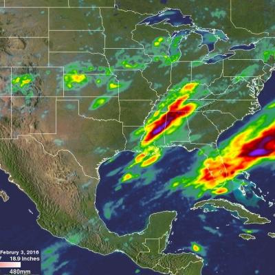
For over a week the weather over the continental United State's has been punctuated by extreme events. Automobiles were thrown around on January 27, 2016 by tornadoes that hit southern Florida. On January 31 a winter storm with heavy rain, strong winds and isolated thunderstorms hit southern California killing at least one person. There were numerous reports of hail with these storms ranging from pea sized to up to an inch in diameter. Powerful winds with these storms also brought down trees and power lines. A blizzard that followed the Democratic and Republican caucuses in Iowa dropped over

NASA Looks At Deadly Weather Over the US

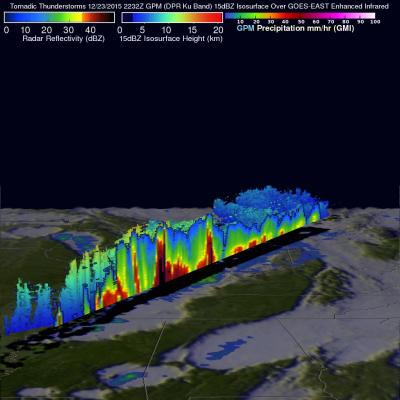
Heavy rainfall, flooding and tornado outbreaks affected areas of the United States from the Southwest through the Midwest from December 23-27, 2015. Tornadoes and flooding events killed at least 43 people during this period. Fourteen deaths alone occurred with tornadoes that hit Benton, Mississippi on December 23, 2015. Tornadoes are expected in the springtime but are much less frequent during this time of the year. An analysis was made of the rainfall that occurred during the period from December 21-28, 2015. This analysis used data generated by NASA's Integrated Multi-satellitE Retrievals