tropical cyclones

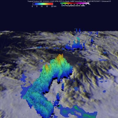
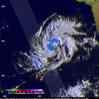
GPM Catches Tropical Cyclone Ula Rebounding

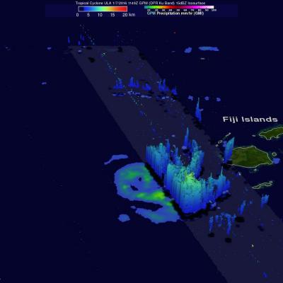
Tropical cyclone ULA weakened to tropical storm intensity after passing south of and then to the west of the Fiji Islands in the South Pacific. ULA has now started to intensify again while moving to the southeast of New Caledonia. The GPM core observatory satellite passed above tropical cyclone ULA on January 7, 2016 at 1149 UTC when maximum sustained wind speeds were estimated at 45 kts (52 mph). Rain was measured by GPM's Dual-Frequency Precipitation Radar (DPR) instrument falling at a rate of 68 mm (2.7 inches) per hour in storms on ULA's southern side. Some of these convective storms were

GPM Sees More Powerful Tropical cyclone 06P (ULA)

The GPM core observatory satellite had an excellent daytime view of tropical cyclone 06P (ULA) on December 30, 2015 at 2358 UTC. The tropical cyclone had moved to the east-southeast of Samoa in the South Pacific Ocean with maximum sustained winds increasing to about 50 kts (58 mph). The rainfall pattern derived from GPM's Microwave Imager (GMI) and Dual-Frequency Precipitation Radar (DPR) instruments showed that 06P was much better organized. Powerful thunderstorms at the center of the tropical cyclone were found by DPR to be dropping rain at a rate of over 66 mm (2.6 inches) per hour. GPM's

GPM Sees Tropical Cyclone Forming

The GPM core observatory satellite passed above tropical cyclone 06P when it was forming in the south Pacific Ocean north of Samoa on December 29, 2015 at 1321 UTC. A rainfall analysis was performed using data collected at that time by GPM's Microwave Imager (GMI) and Dual-Frequency Precipitation Radar (DPR) instruments. Data from GMI were used to calculate that rain was falling at a rate of over 83.6 mm (3.29 inches) per in a feeder band northeast of the low's center. Radar data from GPM's DPR Ku band radar were used to show the 3-D structure of precipitation within the forming tropical

Tropical Cyclone 05S Viewed By GPM

Tropical cyclone 05S formed today in the South Indian Ocean well to the northeast of the islands of Reunion and Mauritius. The GPM core observatory satellite had a perfect view of 05S when the satellite flew over on December 9, 2015 at 1416 UTC. At that time the forming tropical cyclone had sustained winds estimated at 35 kts (40 mph). GPM found that 05S was dropping rain at a rate of over 77 mm (~ 3 inches) per hour in strong convective storms near the tropical cyclone's center of circulation. GPM also saw intense rainfall in a strong feeder band that was converging into the storm's

Yemen Hit by 2nd Tropical Cyclone in a Week

One week ago to the day Cyclone Chapala, the first Category 1 cyclone to strike Yemen in recorded history made landfall on the south-central coast of Yemen, bringing over a year's worth of rain and flooding to that part of the arid country. Today, yet another tropical cyclone, Megh, made landfall in Yemen. Megh, however, made landfall just to the northeast of the coastal city of Aden, which is further west than where Chapala made landfall, and only as a tropical storm. There are, however, several similarities between the two storms. Megh formed in almost the exact same spot in the central

GPM Sees Another Tropical Cyclone Forming

Another tropical cyclone was caught forming by the GPM core Observatory satellite on November 4, 2015 at 1255 UTC. Deadly tropical cyclone Chapala had just dissipated over Yemen when tropical cyclone 05A started forming in the warm waters of the Arabian Sea west of India. GPM measured the rainfall within the forming tropical cyclone using the satellite's Microwave Imager (GMI) and Dual-Frequency Precipitation Radar (DPR) instruments. GMI and DPR found that 05A had scattered light to moderate rainfall falling at a maximum rate of only 23.3 mm (.92 inches) per hour. The Joint Typhoon Warning

Cyclone Chapala Brings Heavy Rains, Flooding to Yemen

Cyclone Chapala, which formed into a rare but powerful Category 4 cyclone in the Arabian Sea with winds at one time estimated at 155 mph by the Joint Typhoon Warning Center (JTWC) back on the 30th of October, made its initial landfall along the south coast of Yemen this morning west of the port city of Mukulla at around 09:00 UTC as a Category 1 cyclone with maximum sustained winds estimated at 75 mph by JTWC, making it the first Category 1 cyclone on record to strike Yemen. The last cyclone to strike the Arabian peninsula was Cyclone Phet, which hit eastern Oman back in 2010. In addition to

GPM Sees Tropical Cyclone Chapala Threatening Yemen

Tropical cyclone Chapala had entered the Gulf Of Aden when the GPM core Observatory satellite passed over on November 2, 1015 at 0311 UTC. Chapala still had maximum sustained winds estimated at about 105kts (121 mph) making it a category three tropical cyclone on the Saffir-Simpson hurricane wind scale. GPM's Microwave Imager (GMI) found that Chapala was dropping rainfall at a rate of over 65 mm (2.6 inches) per hour in intense storms southwest of Chapala's well defined eye. The Joint Typhoon Warning Center (JTWC) predicts that Chapala will weaken before landfall. Chapala is expected to have

GPM Gets a Ton of Kilo

Submitted by JacobAdmin on Mon, 09/21/2015
Video Embed

The Global Precipitation Measurement (GPM) mission core satellite provided many views of Tropical Cyclone Kilo over its very long life. GPM is a satellite co-managed by NASA and the Japan Aerospace Exploration Agency that has the ability to analyze rainfall and cloud heights. GPM was able to provide data on Kilo over its 21 day life-span. 

https://www.youtube.com/watch?v=8eIwMXnU8IA&feature=youtu.be
A narrated visualization of Typhoon Kilo. Click here for a full transcript. Click here to download this video in high resolution from the NASA Goddard Scientific Visualization Studio. The Global Precipitation Measurement (GPM) mission core satellite provided many views of Tropical Cyclone Kilo over its very long life. GPM is a satellite co-managed by NASA and the Japan Aerospace Exploration Agency that has the ability to analyze rainfall and cloud heights. GPM was able to provide data on Kilo over its 21 day life-span. The GPM core observatory satellite flew over Kilo on August 25, 2015 at...