tropical cyclones

How Does NASA Study Hurricanes?
Hurricanes are the most powerful weather event on Earth. NASA’s expertise in space and scientific exploration contributes to essential services provided to the American people by other federal agencies, such as hurricane weather forecasting. The National Oceanic and Atmospheric Administration and the National Hurricane Center (NHC) use a variety of tools to predict these storms’ paths. These scientists need a wealth of data to accurately forecast hurricanes. NASA satellites, computer modeling, instruments, aircraft and field missions contribute to this mix of information to give scientists a...

GPM Views Rare Southern Hemisphere Tropical Cyclone

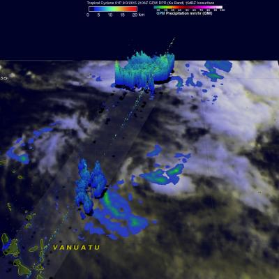
It is a little unusual to see a tropical cyclone forming in the southern Pacific Ocean this time of the year but tropical cyclone 01P formed northeast of Vanuatu recently. The GPM core observatory satellite saw Tropical Cyclone 01P on Monday August 3, 2015 at 2106Z (about 9:06 local time). GPM's Microwave Imager (GMI) found rain falling at a rate of over 30 mm (1.2 inches) per hour in a small area of showers near the center of the tropical cyclone. A 3-D view constructed from GPM's Dual-Frequency Precipitation Radar (DPR) instrument (Ku band) showed that some showers located between the
GPM Flys Over Tropical Cyclone In Arabian Sea JacobAdmin Tue, 06/09/2015
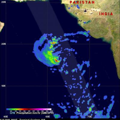
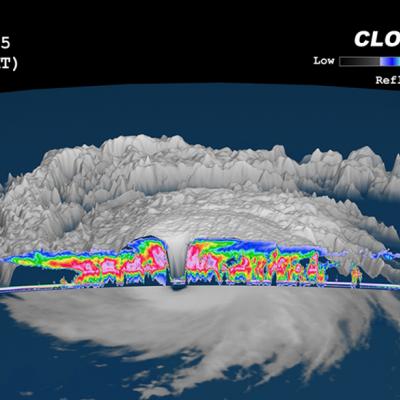
A rare tropical cyclone in the Arabian Sea west of India was seen by the GPM core observatory satellite when it flew over on the morning of June 8, 2015 at 0811Z. Tropical cyclone Ashobaa (TC01A) had sustained wind speeds of about 40 kts (46 mph) when the satellite passed over head. GPM's Microwave Imager (GMI) and Dual-Frequency Precipitation Radar (DPR) instruments measured rain falling at a rate of over 60 mm (2.3 inches) per hour in strong thunderstorms southwest of the storm's center of circulation. A 3-D view was constructed using data from DPR Ku band radar data. This 3-D view of GPM

GPM Sees Remnants of Joalane

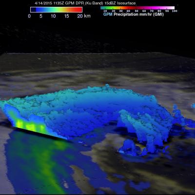
The GPM core observatory satellite had a last look at the remnants of Cyclone Joalane in the South Indian Ocean on April 14, 2015 at 1135 UTC (about 16:35 Local Time). GPM's Microwave Imager (GMI) instrument found very little rainfall around Joalane's center but light to moderate rainfall in bands on the outer edges of the rapidly weakening tropical cyclone.

TRMM Mission Comes to an End

Submitted by JacobAdmin on Wed, 04/15/2015
Video Embed

In 1997 when the Tropical Rainfall Measuring Mission, or TRMM, was launched, its mission was scheduled to last just a few years. Now, 17 years later, the TRMM mission has come to an end. NASA and the Japan Aerospace Exploration Agency (JAXA) stopped TRMM’s science operations and data collection on April 8 after the spacecraft depleted its fuel reserves.

Learn More

The website encountered an unexpected error. Please try again later.
In 1997 when the Tropical Rainfall Measuring Mission, or TRMM, was launched, its mission was scheduled to last just a few years. Now, 17 years later, the TRMM mission has come to an end. NASA and the Japan Aerospace Exploration Agency (JAXA) stopped TRMM’s science operations and data collection on April 8 after the spacecraft depleted its fuel reserves. TRMM observed rainfall rates over the tropics and subtropics, where two-thirds of the world’s rainfall occurs. TRMM carried the first precipitation radar flown in space, which returned data that were made into 3-D imagery, enabling scientists...

TRMM Measures Rainfall In Ikola And Joalane

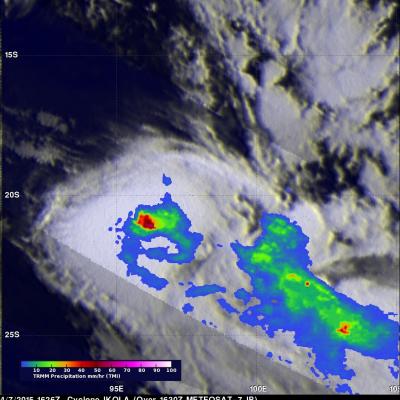
Since being launched in November 1997 the TRMM satellite produced huge volumes of precise precipitation measurements for use in climatology . Near real time collection of data also provided valuable information such as rainfall distribution, three dimensional structure and the stages of development for tropical cyclones. The TRMM satellite saw two tropical cyclones with successive orbits over the the South Indian Ocean on Tuesday April 7, 2015. Cyclone Ikola was the first to come into view when TRMM passed over at 1646 UTC and then the satellite had a good look at cyclone Joalane at 1755 UTC

GPM Looks Into Cyclone Joalane's Eye

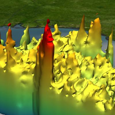
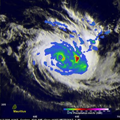
Cyclone Joalane had developed a small clear eye when the GPM core observatory satellite passed above on April 7, 2015 at 1436 UTC. GPM's Microwave Imager (GMI) data showed that the heaviest rain was falling at a rate of over 78.6 mm (3 inches) per hour in a feeder band wrapping around Joalane's eastern side. This simulated 3-D flyby around Joalane was made using data from the Ku band on GPM's dual frequency radar. Those radar data discovered that the intense thunderstorms, reaching heights above 16 km (9.9 miles), were located where the heaviest rainfall was measured by GPM's GMI.
GPM Measures Rain in Cyclone Joalane JacobAdmin Wed, 04/08/2015
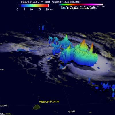
Two powerful tropical cyclones called Ikola and Joalane are now moving through the South Indian Ocean. The GPM core observatory satellite flew over intensifying cyclone Joalane in the South Indian Ocean on April 6, 2015 at 0406 UTC. GPM's Microwave Imager(GMI) found that intense convective thunderstorms within Joalane were dropping rain at a rate of over 63 mm (2.5 inches) per hour. Cyclone Joalane was located northeast of Mauritius at the time of this GPM pass. A 3-D view of Joalane's vertical precipitation structure was constructed from GPM's Radar (Ku Band) data. This cross section shows