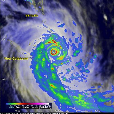
tropical cyclones

Cyclone Ikola

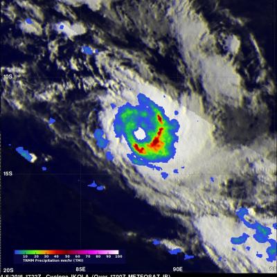
The TRMM satellite's Microwave Imager (TMI) instrument collected data used in this rainfall analysis when the satellite flew over tropical storm Ikola in the South Indian Ocean on April 5, 2015 at 1722 UTC. TMI data revealed the location of rain falling at a rate of over 50 mm (amost 2 inches) per hour around Ikola's eye.
GPM's Worldwide Tour of Global Precipitation
Rain, snow, hail, ice, and every mix in between make up the precipitation that touches everyone on our planet. But precipitation doesn't fall equally in all places around the world, as seen in NASA's new animation that captures every shower, snowstorm and tropical cyclone over a six-day period in August 2014. The time lapse was created from data captured by the Global Precipitation Measurement (GPM) satellite mission, now just over a year old, which scientists are using to better understand freshwater resources, natural disasters, crop health and more. Image Credit: NASA's Goddard Space Flight...

Cyclone Nathan Dissipates

The GPM core observatory satellite saw dissipating cyclone Nathan when it flew over Australia's Top End on March 24, 2015 at 0256 UTC. Nathan was shown dropping light to moderate rain after being cut off from moisture flowing from the Arafura Sea and the Gulf Of Carpentaria. The Joint Typhoon Warning Center (JTWC) predicts that Nathan will continue to weaken for the next few days while traveling westward over land.

GPM And TRMM See Glenda At Same Time

Tropical storm GLENDA formed over the open waters of the South Indian Ocean southeast of Diago Garcia on February 24, 2015. GLENDA didn't get above tropical tropical storm intensity and has not posed a significant threat to islands in the area. An interesting event occurred on February 25, 2015 when both the TRMM satellite and it's successor the GPM core observatory satellite passed over the tropical cyclone at almost the same time. This 3-D view was constructed from GPM Radar data (Ku Band) collected with the 1521 UTC pass. It shows the vertical structure of tropical storm GLENDA along the

Cyclone Nathan Circles Back

Cyclone Nathan located in the Coral Sea off Australia's Queensland coast has made another loop and is again headed slowly toward the Cape York Peninsula. Rainfall derived from the TRMM satellite's Microwave Imager (TMI) and Precipitation Radar (PR) instruments is shown with data collected on March 18, 2015 at 0758 UTC. The heaviest rainfall was measured by TRMM PR falling at a rate of over 119 mm (4.7 inches) on the eastern side of Nathan's eye. TRMM PR data were used in this 3-D view of cyclone Nathan. Storm heights in a rain band circling Nathan's northwestern side were found reaching

Cyclone Pam Departs Vanuatu

As one of the strongest cyclones every recorded in the South Pacific, Cyclone Pam devastated the island archipelago of Vanuatu. As the cyclone bore down on Vanuatu's central islands on the afternoon (local time) of March 13th, Pam's maximum sustained winds were estimated to have increased to 270 kph (~167 mph) by the US Joint Typhoon Warning Center (JTWC), making it a category 5 storm on the US Saffir-Simpson scale. The storm caused immense, widespread damage with the islands of Erromango and Tanna suffering a direct hit. Although damage is still being assessed, the number of reported

Tropical Cyclone Eunice

Tropical cyclone Eunice became the fourth tropical cyclone of the 2015 Southern Indian Ocean season when it formed well east of Madagascar on January 27, 2014. Maximum sustained winds within the tropical cyclone have increased to about 85kts (~98 mph) and Eunice is predicted by the Joint Typhoon Warning Center (JTWC) to continue becoming more powerful as it travels toward the southeast. The GPM (core satellite) flew directly over the eye of newly formed tropical cyclone on January 28, 2015 at 1049 UTC. GPM's Microwave Imager (GMI) found that rain was falling at a rate of only 30.2 mm (about 1

Southwest Indian Ocean Has Two Tropical Cyclones

As tropical storm Mekkhala approaches the Philippines in the northern hemisphere tropical cyclone activity in the southeast Indian ocean has recently increased. The TRMM satellite has been monitoring rainfall in the tropics since 1997. On February 15, 2015 the TRMM satellite flew over two tropical cyclones in successive orbits. BANSI 1/15/2015 1308Z CHEDZA 1/15/2015 1440Z Rainfall derived from TRMM's Microwave Imager (TMI) is shown overlaid on a METEOSAT-7 Visble/Infrared images. On January 15, 2015 at 1308 UTC the satellite saw powerful category four tropical cyclone Bansi northeast of the

TRMM And GPM Core Satellite See Sinlaku Headed Toward Vietnam

Tropical storm Sinlaku formed on November 26, 2014 over the southeastern Philippines. As a tropical depression Sinlaku caused flooding in areas of the Visayas and Mindanao. The TRMM and the GPM core satellite viewed Sinlaku after it had strengthened into a tropical storm over the South China Sea. The first image shows rainfall derived from TRMM Microwave Imager (TMI) data collected when the satellite flew over on November 28, 2014 at 0716 UTC. The second view shows rainfall from GPM Microwave Imager (GMI) measurements received a little over six hours later at 1326 UTC. Rainfall was measured by
Goodbye to TRMM, First Rain Radar in Space
After 17 years of groundbreaking 3-D images of rain and storms, the joint NASA and Japan Aerospace Exploration Agency Tropical Rainfall Measuring Mission (TRMM) will come to an end next year. NASA predicts that science operations will cease in or about April 2015, based on the most recent analysis by mission operations at NASA’s Goddard Space Flight Center, Greenbelt, Maryland. Artist concept of TRMM in space over the eye of a tropical cyclone. Image Credit: NASA On July 8, 2014, pressure readings from the fuel tank indicated that TRMM was near the end of its fuel supply. As a result, NASA...