tropical cyclones

Cyclone Hudhud Makes Landfall, Brings Potential for Heavy Rains to Himalayas

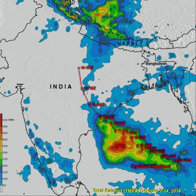
Cyclone Hudhud, which reached the equivalent of a category 4 hurricane on the US Saffir-Simpson scale over the Bay of Bengal, weakened slightly before making landfall Sunday morning (local time) on the central southeast coast of India near the port city of Visakhapatnam. Hudhud came ashore with wind gusts of up to 120 mph and so far is being blamed for 24 fatalities in India. The TRMM-based, near-real time Multi-satellite Precipitation data (TMPA) analysis is used to monitor rainfall over the global Tropics. A TMPA rainfall analsis for the period 7-14 October 2014 over India and the

Moisture From Norbert Spreads Heavy Rain Over Southwest

The TRMM satellite flew above the post-tropical cyclone remnants of former hurricane Norbert on September 8, 2014 at 0849 UTC (1:49 AM PDT). This image shows TRMM rainfall derived from the Microwave Imager (TMI) and Precipitation Radar (PR) instruments overlaid on a 0900 UTC GOES-EAST enhanced Infrared image. These data show that only a small amount of light to moderate rainfall was located around Norbert's center of circulation. This view shows that heavy rainfall was being produced over the southwestern United States. This 3-D image was made from TRMM Precipitation Radar (PR) data. It shows

Norbert & Dolly Rain On Both Mexican Coasts

Tropical storm Dolly dissipated quickly after coming ashore yesterday in eastern Mexico but dropped heavy rain in some areas near the Gulf coast. At the same time tropical storm Norbert was approaching from the west and contributing to rainfall near Mexico's Pacific coast. TRMM-based, near-real time Multi-satellite Precipitation Analysis (MPA) data for the period from August 28 to September 4, 2014 were used in the analysis shown above. The approximate past locations of the tropical cyclones at 0000Z and 1200Z are shown overlaid in red on this analysis. The heaviest rainfall totals were found

Active Eastern & Central Pacific Hurricane Season

Tropical cyclones are frequently forming during this active hurricane season in the eastern and central Pacific ocean. As hurricane Julio was fading in the central Pacific Ocean north of Hawaii, hurricane Karina was forming on August 13, 2013 off the Mexican coast. The TRMM satellite passed directly above the center of intensifying tropical storm Karina on August 14, 2014 at 1927 UTC. A rainfall analysis that used data from TRMM's Microwave Imager (TMI) is shown overlaid on a GOES-WEST image received at 1930 UTC. TRMM TMI showed that storms near Karina's center were dropping rain at a rate of

Matmo's Menacing Taiwan

The TRMM satellite saw typhoon Matmo nearing Taiwan on July 21, 2014 at 2316 UTC. TRMM's Microwave Imager (TMI) and Precipitation Radar (PR) showed that Matmo contained a large area of precipitation falling at a rate of over 61 mm (about 2.4 inches) per hour northeast of Matmo's center. After battering Taiwan today, typhoon Matmo is predicted to make a second landfall in China tomorrow.

Deadly Typhoon Rammasun Crosses The Phillipines

Typhoon Rammasun known locally as "Glenda" is the most powerful typhoon to hit the Philippines this year. As of today, Ten deaths have been attributed to Rammasun. Flooding and landslides are expected due to heavy rainfall. Typhoon Rammasun's track was north of Super Typhoon Haiyan's path of destruction through the Philippines in November 2013. The image above is a preliminary analysis of rainfall during the period when typhoon Rammasun was moving over the Philippines. Typhoon Rammasun's track is shown in red. This analysis is the result of a TRMM-calibrated merged global Multi-satellite

Typhoon Rammasun Strikes The Philippines

Today typhoon Rammasun is pounding the Philippines with strong winds and heavy rainfall. Rammasun was labeled a tropical storm on July 12, 2014 when it formed west of Guam. Rammasun strengthened and was upgraded to a typhoon on July 14, 2014. Typhoon Rammasun became still more powerful and had winds estimated at 100kts (about 115 mph) today making it a category three tropical cyclone on the Saffir-Simpson hurricane wind scale. The images above show typhoon Rammasun as the TRMM satellite flew over on July 14, 2014 at 1819 UTC and again on July 15, 2014 at 0410 UTC. These images show that

Neoguri A Little Weaker

TRMM satellite had another good view of typhoon NEOGURI on July 8, 2014 at 0545 UTC. With wind speeds of 110 kts (about 127 mph) NEOGURI had weakened to a strong category three typhoon. A rainfall analysis from TRMM's Microwave Imager (TMI) and Precipitation Radar (PR) is shown overlaid on a MTSAT Visible/Infrared image from 0600 UTC. Rainfall was measured by TRMM PR falling at a rate of over 117 mm (about 4.6 inches) per hour in a rain band affecting Okinawa. A simulated 3-D view (from the east) shows NEOGURI's rainfall structure at the time of this TRMM satellite pass. Powerful thunderstorms

Boris Dissipates, Atlantic Disturbance Stengthens

On June 5, 2014 at 0549 UTC (1:49 AM EDT) the TRMM satellite flew above the remnants of tropical Depression Boris and powerful thunderstorms that recently developed in the Gulf of Mexico. Rainfall derived from TRMM Microwave Imager (TMI) and Precipitation Radar (PR) data are shown overlaid on an enhanced infrared image from the GOES-EAST satellite. TRMM found heavy rainfall over Mexico's Pacific coast and with a disturbance in the Gulf Of Mexico (90L). Rainfall was falling at the extreme rate of over 163 mm (about 6.4 inches) per hour in powerful thunderstorms associated with the low pressure

Boris Intensifies, Hits Mexico And Dissipates

Tropical Depression TWO-E was upgraded to tropical storm Boris yesterday at 1800 UTC (11AM PDT) but Boris weakened to a tropical depression after going ashore in Mexico. The TRMM satellite passed above tropical depression Boris on June 4, 2014 at 1457 UTC and collected data used in this rainfall analysis. TRMM rainfall data are shown overlaid on a GOES-EAST enhanced infrared/visible image received at 1445 UTC. TRMM's Microwave Imager (TMI) data show that Boris was still dropping light to moderate rain over southern Mexico in the area of the Gulf Of Tehuantepec. Click on this animation to see a