tropical storms

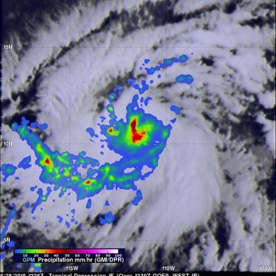
GPM Passes Over New Tropical Storm Blanka

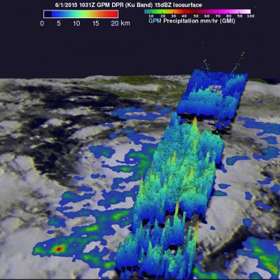
Today a new tropical storm called Blanka formed in the eastern Pacific Ocean off southwestern Mexico. The GPM core observatory satellite flew over the forming tropical storm on June 1, 2015 at 1031 UTC (5:31 AM CDT). Rainfall data collected by GPM's Microwave Imager (GMI) and Dual-Frequency Precipitation Radar (DPR) instruments are shown The location of Blanka's center of circulation within a large area of convective thunderstorms was clearly outlined by GPM's GMI derived rainfall. A 3-D view derived from DPR's Ku Band radar data shows that several areas of intense rainfall were located east

First 2015 Tropical Storm Forms In Eastern Pacific

Tropical storm Andres became the first tropical storm of the the 2015 Eastern Pacific hurricane season today at 1500 UTC (9 AM MDT). The GPM core observatory satellite flew over the intensifying tropical cyclone (TD1E) at 1225 UTC ( 6:25 AM MDT). Rainfall data from GPM's Microwave Imager (GMI) and Dual-Frequency Precipitation Radar (Ku Band) instruments are shown overlaid on an enhanced GOES-EAST satellite infrared image received at 1230 UTC (6:30 AM MDT). Rain was found by GMI to be falling at a rate of over 60 mm (2.4 inches) per hour in powerful convective storms near Andres' center. Data

Ana Becomes First 2015 Atlantic Tropical Storm & Weakens Ashore

On May 9, 2015 at 1626 UTC ( 12:26 PM EDT) the GPM satellite flew over when Ana was making the change from subtropical storm to tropical storm. Convective storms near the inner-core region were warming the center of the storm with heat generated by condensation. GPM's Microwave Imager (GMI) measured rain falling at at rate of over 58.7 (2.31 inches) per hour in these convective storms near ANA's center. The lighter swath to the west of Ana's center shows the area viewed by GPM's Ku/Ka-band Dual-frequency Precipitation Radar (DPR). On Sunday morning (May 10, 2015) Tropical storm ANA dropped

GPM Measures Rainfall In Tropical Storm Adjali

Moderate rainfall was occurring around the center of Tropical Storm Adjali before it dissipated, according to data from NASA and the Japan Aerospace Exploration Agency's Global Precipitation Measurement or GPM satellites. Adjali became the first named storm of the Southwest Indian Ocean 2014/2015 cyclone season when it formed on November 16, 2014. Adjali became a strong tropical storm the next day and just two days later started to dissipate. The GPM observatory captured data on Adjali's rainfall rates on Nov. 18. GPM's Microwave Imager (GMI) instrument is similar to the Tropical Rainfall

Tropical Storm Vance Forms

The hurricane season continues to be active in the eastern Pacific Ocean. A Tropical depression south of southern Mexico was upgraded to tropical storm Vance yesterday. The National Hurricane Center (NHC) predicts that Vance will become a hurricane Sunday morning making it the sixteenth hurricane of the 2014 eastern Pacific Ocean hurricane season. TRMM's Microwave imager (TMI) had a good view of the rainfall around tropical storm Vance on October 31, 2014 at 0234 UTC. An analysis of this rainfall is shown overlaid on a 0245 UTC GOES-EAST enhanced infrared image. Intense convective

Tropical Storm Ana Still Vigorous

The TRMM satellite flew over tropical storm ANA on October 22, 2014 at 1935 UTC (about 8:30 AM local time). ANA formed over ten days ago but after moving to the northwest of the Hawaiian islands the tropical storm was shown to be still vigorous. A rainfall analysis from TRMM's Microwave Imager (TMI) revealed an area near ANA's center of circulation where rain was falling at a rate of over 40 mm (about 1.6 inches) per hour. The Joint Typhoon Warning Center (JTWC) predicts that ANA will maintain tropical storm intensity for the next five days while moving over open waters toward the northwest.

Tropical Storm Rachel

Tropical depression 18E, located southwest of Mexico, became tropical storm Rachel on September 24, 2014 at 1500 UTC (8 PM PDT). The TRMM satellite had a good view of Rachel when it flew over early today at 0608 UTC (September 25, 2014 at 11:08 PM PDT). A precipitation analysis that used TRMM's Microwave Imager (TMI) data is shown overlaid on a 0600Z GOES-WEST enhanced infrared image. This image shows that, due to northeasterly wind shear, convective precipitation was located southwest of of Rachel's center of circulation. The heaviest rain was shown falling at a rate of over 50mm (amost 2

Tropical Storm Edouard forms in the Atlantic

The formation of Tropical Storm Edouard in the central Atlantic marks the climatological peak of the Atlantic hurricane season in what has so far been a rather average season in terms of the number of storms. Edouard became the fifth named storm of the season after forming overnight in the central Atlantic about 1645 km (~1020 miles) west of the Cape Verde Islands. In a typical season there are about 10 named storms and 6 hurricanes. So far this year, halfway through the season, there have been 5 named storms and 3 hurricanes, but none have posed a major threat to the US, and there have been

Tropical Storm Odile Forms

The hurricane season continues to be active in the eastern Pacific Ocean. Hurricane Norbert dissipated a few days ago and then tropical storm Odile formed yesterday (September 10, 2014) in the same area where Norbert formed. The TRMM satellite flew over tropical storm Odile on September 11, 2014 at 0418 UTC and collected data used in the images above. The first image shows a rainfall analysis made from TRMM's Microwave Imager (TMI) and Precipitation Radar (PR) data overlaid on a 0430 UTC GOES-WEST enhanced infrared image. TRMM PR found that Odile was dropping rain at the extreme rate of over

Tropical Storm Dolly Hits Eastern Mexico

Tropical storm Dolly is dissipating after coming ashore in eastern Mexico late yesterday evening. The TRMM satellite flew over tropical storm Dolly early on September 3, 2014 at 0844 UTC ( 3:33 AM CTD) providing data used in the image above. TRMM's Microwave Imager (TMI) collected with that orbit showed that Dolly was dropping light to moderate rainfall near the dissipating storm's center of circulation. Moderate to heavy rainfall, falling at a rate of over 30 mm ( about 1.2 inches) per hour, was shown in a strong band of showers moving ashore north of Dolly's center. The TRMM satellite had a