tropical storms

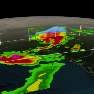
GPM Sees Tropical Cyclone Drenching Bangladesh

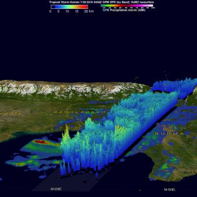
Bangladesh was already soaked by monsoon rainfall before recently formed tropical storm Komen started drenching the area. The GPM core observatory satellite collected data above the tropical cyclone on on July 30, 2015 at 0436 UTC ( 10:36 AM BDT). GPM's Microwave Imager (GMI) measured rain falling at the extreme rate of close to 150 mm (5.9 inches) per hour in powerful storms over the Bay Of Bengal. A 3-D view of thunderstorm tops based on radar reflectivity day from GPM's Dual-Frequency Precipitation Radar (DPR) is shown here. DPR (Ku band) radar data were used in this simulated cross section

GPM Looks At Tropical Storm Claudette

The National Hurricane Center (NHC) issued it's first advisory for tropical storm Claudette on Monday July 13, 2015 at 1PM AST. The GPM core observatory satellite had an outstanding view as it flew above tropical storm Claudette on the early evening of July 13, 2015 at 2046 UTC (4:46 PM EDT). Rainfall measurements were made by GPM’s Microwave Imager (GMI) and Dual-Frequency Precipitation Radar (DPR) instruments. Claudette is a relatively small tropical storm with vertical wind shear dampening future development but GPM found heavy rainfall in some strong thunderstorms. GPM's radar instrument

NASA Sees Heavy Rainfall in Tropical Storm Halola

The GPM satellite passed over Tropical Storm Halola in the northwestern Pacific Ocean and found heaviest rainfall occurring north of the center of circulation. Halola formed in the Central Pacific Ocean and moved into the Northwestern Pacific Ocean basin today, July 13. On July 13 at 1500 UTC (11 a.m. EDT) Tropical Storm Halola had maximum sustained winds near 60 knots (69 mph/111.1 kph). It was located near 14.5 North and 177.0 East, about 694 nautical miles (798 miles/1,285 km) east-southeast of Wake Island. Halola has tracked west-northwestward at 11 knots (12.6 mph/20.3 kph). The Global

Tropical Storm Ela To Pass Near Hawaiian Islands

A tropical storm called Ela formed east-southeast of the Hawaiian Islands on July 8, 2015 and is expected to pass to the north of the island chain this weekend. GPM had a good view of Ela as the satellite flew over the forming tropical storm on July 8, 2015 at 1316 UTC (3:16 AM HST). The satellite passed above Ela again on July 9, 2015 at 0234 UTC (July 8, 2015 4:34 PM HST) showing that rainfall bands associated with the tropical cyclone were better organized. GPM's Microwave Imager (GMI) and Dual-Frequency Precipitation Radar (DPR) instruments found today that rainfall was falling at a rate

GPM Has A Good Look At Tropical Storm Raquel

The GPM core observatory satellite recently had an excellent view of tropical storm Raquel in the South Pacific Ocean. Raquel was moving over the Solomon Islands on July 1, 2015 at 0749 UTC when viewed by GPM. Tropical cyclone activity normally ramps up in the northern hemisphere this time of the year so Raquel's development yesterday north of the Solomon Islands was a little surprising. Rainfall was measured by GPM's Dual-Frequency Precipitation Radar (DPR) and Microwave Imager (GMI) instruments. Those data showed that powerful thunderstorms within Raquel were dropping rain at a rate of over
GPM Sees Tropical Storm Bill Over Texas
Download in hi-res from the NASA Goddard Scientific Visualization Studio Tropical Storm Bill made landfall over Texas at approximately 11:45am CST on June 16, 2015. Shortly after midnight, GPM passed over the storm as it slowly worked it's way northward across the already drenched state of Texas. This visualization shows Bill at precisely 12:11:27am CST (6:11:27 GMT) on June 17, 2015. The GPM Core Observatory carries two instruments that show the location and intensity of rain and snow, which defines a crucial part of the storm structure – and how it will behave. The GPM Microwave Imager sees...

Weakening Tropical Storm Bill Seen By GPM

The GPM core observatory satellite had a good daytime look at tropical storm Bill on Wednesday June 17, 1015 at 1552 UTC ( 10:52 AM CDT). GPM saw that an area of heavy rain on Bills northern side was then moving into southern Oklahoma. The Dual-Frequency Precipitation Radar (DPR) on board the satellite measured rain dropping at a rate of over 50 mm (almost 2 inches) per hour in some intense storms. GPM radar data (Ku band) were also used to look at the 3-D structure and storm top heights within storms associated with tropical storm Bill. This image shows that in some areas the dissipating

IMERG Sees Gulf Rainfall With Tropical Storm Bill

Tropical storm Bill became the second named tropical cyclone in the Atlantic Ocean Basin when it formed in the western Gulf Of Mexico on June 16, 2015. Data from the NASA's Integrated Multi-satellitE Retrievals for GPM (IMERG) was used in this analysis to estimate rainfall from Tropical Storm Bill. Precipitation was analyzed from the time when tropical storm Bill was forming in the Gulf Of Mexico on Monday June 15, 2015 until early this morning at 0800 UTC (4 AM CDT). The storm was dropping heavy rainfall over Texas this morning but this analysis indicates that the heaviest rainfall totals, up

Tropical Storm Carlos Viewed By GPM

Tropical storm Carlos is the third tropical cyclone in what promises to be a busy 2015 eastern Pacific hurricane season. The GPM core observatory satellite flew directly above Carlos on June 12, 2015 at 0716 UTC. GPM's Microwave Imager (GMI) and Dual-Frequency Precipitation Radar (DPR) instruments showed that heavy rain was falling in a band of powerful storms to the southeast of the tropical storm's center of circulation. Rainfall was measured by GPM radar (Ku band) falling at a rate of almost 70 mm (2.8 inches) per hour in Carlos' most intense areas of rainfall. Those same radar data were

Tropical Cyclone Ashobaa Contains Powerful Storms

The GPM core observatory had another excellent view of tropical cyclone Ashobaa in the Arabian Sea over on June 8, 2015 at 2131 UTC. As expected, Ashobaa was more powerful than when seen by GPM earlier in the day. GPM's Microwave Imager (GMI) and Dual-Frequency Precipitation Radar (DPR) instruments showed that rain was falling at a rate of over 70.5 mm (about 2.8 inches) per hour in bands of storms west of the center of circulation. Very powerful storms were seen west of tropical cyclone Ashobaa's center of circulation by GPM's Ku Band Radar. A 3-D view constructed from GPM's Ku band radar