tropical storms

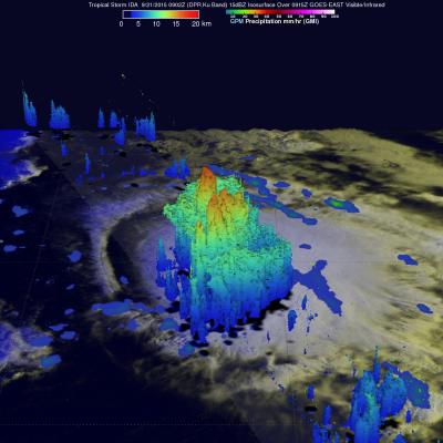
GPM Sees Powerful Storms Within Tropical Storm Ida

The GPM core observatory satellite found that tropical Storm IDA contained some very powerful convective thunderstorms when the satellite passed over on September 21, 2015 at 0902 UTC (05:02 AM EDT). The satellite passed directly above the most powerful storms within IDA where rain was measured by GPM's Microwave Imager (GMI) and Dual-Frequency Precipitation Radar (DPR) instruments. DPR found that some thunderstorms were dropping rain at a rate of over 142 mm (5.6 inches) per hour. GPM's DPR (Ku Band) radar data were used examine the 3-D structure of precipitation within tropical storm IDA

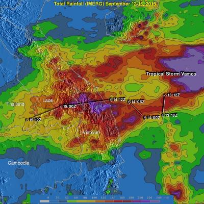
Tropical Storm Vamco Brings Rain To Southeast Asia

Tropical storm Vamco formed in the South China Sea on September 13, 2015 and went ashore in Vietnam a few days later. Although short lived Vamco dropped very heavy rainfall over the mountainous terrain of central Vietnam and in Laos and eastern Thailand. An Integrated Multi-satellite Retrievals for GPM (IMERG) rainfall analysis is shown here for the period from September 12-15, 2015. This analysis indicates that during this short period over 220 mm (8.7 inches) rain fell along the tropical storm's path. Flash floods and landslides were likely in areas where this drenching rainfall occurred.

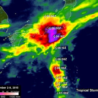
Wednesday September 9, 2015 Japan's Torrential Rain Measured With IMERG

Over the past week Japan has experienced extreme rainfall that resulted in flooding, landslides and many injuries. A nearly stationary front that was already moving over Japan caused much of the rain but tropical storm ETAU also interacted with the front and magnified the scale of the deluge. Heavy rainfall led to the evacuation of over one million people. This rainfall analysis from space was generated using NASA's Integrated Multi-satellite Retrievals for GPM (IMERG) data. It shows rainfall total estimates for Japan during the seven day period from September 2-9, 2015 when Japan was getting

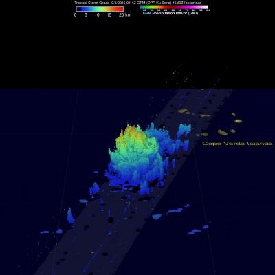
Tropical Storm Grace Viewed by GPM

On Saturday September 5, 2015 a tropical disturbance south of the Cape Verde Islands in the eastern Atlantic Ocean was designated tropical depression number seven (TD7). TD7 was subsequently upgraded to tropical storm Grace that evening after the tropical depression showed increasingly better organization. The GPM core observatory satellite flew above tropical storm Grace on September 6, 2015 at 0111 UTC. Data captured by GPM's Microwave Imager (GMI) and Dual-Frequency Precipitation Radar (DPR) instruments with that pass showed that the tropical storm was small but had well defined curved
GPM Sees Fred Forming In Cape Verdes JacobAdmin Mon, 08/31/2015
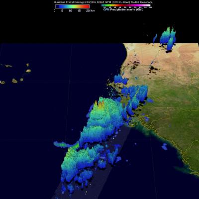
Fred became the first Cape Verdes hurricane of the 2015 Atlantic season when it was upgraded from a tropical storm on August 31, 2015 at 0600 UTC (2 AM AST). The GPM core observatory satellite flew over on August 30, 2015 at 0236 UTC when Fred was forming from a tropical wave that moved off the African coast. Rainfall was measured by GPM's Dual-Frequency Precipitation Radar (DPR) at the extreme rate of close to 128 mm (5.0 inches) per hour. Rainfall in towering convective thunderstorms at Fred’s center of circulation were providing the energy necessary for intensification into a hurricane

Tropical Storm Erika Enters the Caribbean

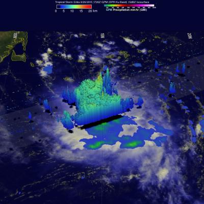
Tropical Storm Erika, the 5th named storm of the season, entered the northeast Caribbean early this morning as it passed through the Leeward Islands between Guadeloupe and Antigua. Fortunately, there were no reports of damage thanks in part to the effects of inhibiting wind shear, which kept the storm from strengthening. Erika originated as a wave of low pressure that was first detected on Friday the 21st of August midway between the West Coast of Africa and the Cape Verde Islands. The wave then tracked westward across the tropical mid Atlantic where it eventually intensified enough to become

Tropical Depression Twelve Upgraded To Tropical Storm Ignacio

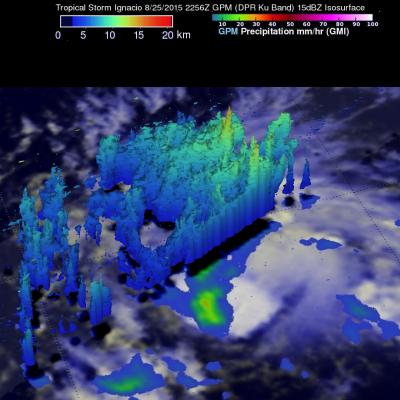
Today tropical Storm Ignacio became the 16th 2015 tropical cyclone to form in the eastern Pacific this year putting it a couple weeks ahead of last year’s pace. The GPM core observatory satellite saw Ignacio on August 25, 2015 at 2256 UTC. GPM’s Dual-Frequency Precipitation Radar (DPR) found rain falling at a rate of over 74 mm (2.9 inches) per hour with storm tops reaching to altitudes of close to 15 km (8.7 miles).

Tropical Storm Danny Forms in the Atlantic

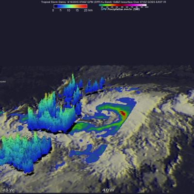
Tropical Storm Danny became the 4th named storm of the season yesterday afternoon when it formed in the central Atlantic about 1660 miles east of the Windward Islands. Danny originated from an African easterly wave that moved off of the coast of Africa 4 days earlier on the 14th of August. Storms that form in this region are known as Cape Verde storms and typically form towards the height of hurricane season. In a typical season, there are about 10 named storms and 6 hurricanes. With this year being a potentially strong El Nino year, Atlantic hurricanes are usually suppressed. However, it only

Another Typhoon Headed Toward Taiwan And China

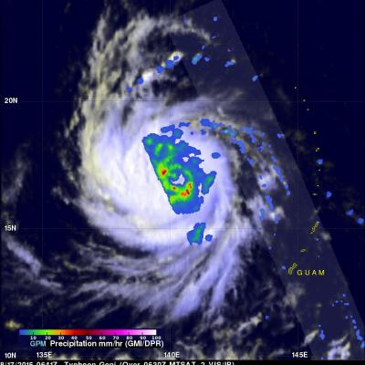
Last week deadly typhoon Soudelor caused at least 22 deaths in Taiwan and China. The GPM core observatory satellite recently had two good views of intensifying typhoon Goni that formed on August 14, 2015 in the same area of the Pacific Ocean as typhoon Soudelor. Typhoon Goni is forecast by the Joint Typhoon Warning Center (JTWC) to become a very powerful typhoon in the next week while moving along a track similar to typhoon Soudelor. Typhoon Goni could affect the same areas of the western Pacific Ocean. The first image shows a GPM satellite pass over Goni when the tropical cyclone was moving

GPM Says Goodbye to Tropical Storm Molave

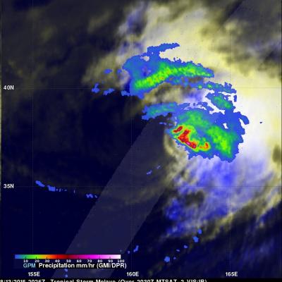
Tropical storm Molave became the 16th named tropical cyclone when it formed on August 7, 2015 and spent the past week over the open waters of the Pacific Ocean. For a few days Molave moved toward Japan but re-curved toward the northeast and passed well to the southeast of Japan. Molave became an extratropical cyclone and the Joint Typhoon Warning Center (JTWC) issued it's last warning on August 13, 2015 at 2100 UTC. Molave was last seen as a tropical storm by the GPM core observatory satellite on August 13, 2015 at 2026 UTC. Molave's rainfall intensity was measured with this satellite pass by