tropical storms

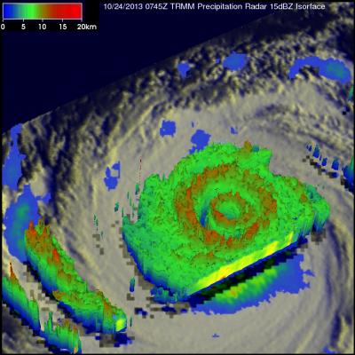
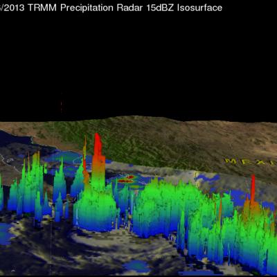
Tropical Storm Raymond Fading Fast

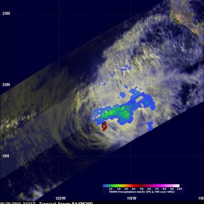
There has been some recent convective activity within tropical storm Raymond but southwesterly wind shear and cooler ocean temperatures are predicted by the National Hurricane Center (NHC) to weaken the tropical storm to a remnant low on Wednesday October 30, 2013. Raymond contained rainfall only in an area northwest of it's center of circulation when the TRMM satellite passed above on October 28, 2013 at 2337 UTC (4:37 PM PDT). Rainfall data from TRMM's Microwave Imager (TMI) and Precipitation Radar (PR) are shown overlaid on a combination visible and infrared image from TRMM's Visible and

TRMM Sees Two Pacific Tropical Cyclones

Tropical Storm Lekima Tropical Storm Francisco The TRMM satellite flew above the centers of two tropical cyclones in the western Pacific Ocean early this morning. The first orbit saw super typhoon LEKIMA at 0745 UTC and with the next orbit tropical storm FRANCISCO came into view at 0919 UTC. Lekima was located southeast of tropical storm Francisco over the open waters of the Pacific. Precipitation data from TRMM's Microwave Imager (TMI) and Precipitation Radar (PR) instuments are shown overlaid on infrared images from TRMM's Visible and InfraRed Scanner (VIRS). These rainfall analyses show the

Mexico Flooded by Tropical Storm Manuel and Hurricane Ingrid

Mexico's Pacific and Gulf coasts were both inundated by deadly tropical rainfall at the same time. Hurricane Manuel dropped extremely heavy rainfall along Mexico's Pacific coast. At least 55 people have been reported killed in Mexico due to flooding and landslides caused by extreme rainfall. Hurricane Ingrid weakened to a tropical storm and came ashore from the Gulf Of Mexico into the state of Tamaulipas near La Pesca, Mexico on Monday September 16,2013. The approximate 0000Z and 1200Z locations of the tropical cyclones are shown overlaid in white. The TRMM-based, near-real time Multi-

Tropical Storm Humberto

The TRMM satellite had another good daytime look at tropical storm Humberto on September 17, 2013 at 1639 UTC (12:39 PM EDT). Rainfall data from TRMM's Microwave Imager (TMI) and Precipitation Radar (PR) are shown overlaid on a visible/infrared image from TRMM's Visible and InfraRed Scanner (VIRS). The most intense echo found by TRMM PR was 48.3dBZ with rain falling at a rate of 56.5mm/hr (~2.22 inches) in an area north-northeast of Humberto's center. A red tropical storm symbol shows Humberto's approximate circulation center location.

Tropical Storm Humberto Rebounds

Tropical storm Humberto, located in the eastern Atlantic Ocean, had little deep convection and was classified by the National Hurricane Center (NHC) as a post-tropical cyclone on September 14, 2013. On September 16, 2013 Humberto was having bursts of strong convection and was again classified a tropical storm. Humberto was viewed during the daytime by the TRMM satellite on September 15, 2013 at 1652 UTC (12:52 PM EDT) and on September 16, 2013 at 1557 UTC (11:57 AM EDT). These TRMM orbits show the significant changes that occurred within Humberto's in less than 24 hours. In the first orbit on

Gabrielle Seen Knocking On Bermuda's Door

Tropical storm Gabrielle was at a distance of about 50km (~31 miles) to the south-southwest of Bermuda on September 11, 2013 at 0041 (September 10, 2013 8:41 PM EDT) when the TRMM satellite flew above. A rainfall analysis from TRMM's Microwave Imager (TMI) and Precipitation Radar (PR) is shown overlaid on an enhanced infrared image from the satellite's Visible and InfraRed Scanner (VIRS). A band of light to moderate rainfall extends to Bermuda from a large area of heavy rainfall in the eastern side of Gabrielle. A red tropical storm symbol shows the surface location of tropical storm Gabrielle

TRMM Sees Gabrielle Closing In On Bermuda

The TRMM satellite flew directly above tropical storm Gabrielle on September 10, 2013 at 2124 UTC (5:24 PM EDT) as the storm approached Bermuda. TRMM's Precipitation Radar (PR) data found that rain was falling at a rate of over 127mm/hr (~5 inches) in a line of intense storms southeast of Bermuda. TRMM PR also found that the tallest thunderstorms, reaching to heights above 15.5km (~9.6 miles), were located in an area close to Gabrielle's center of circulation. Click here to see a simulated 3-D (Quicktime) flyby animation over Gabrielle approaching Bermuda using TRMM PR data. Click here to see

Tropical Storm Gabrielle Revived

Tropical storm Gabrielle dissipated to below tropical depression intensity on September 5, 2013. Gabrielle has regenerated and was again classified this morning as a tropical storm by the National Hurricane Center (NHC). This image shows a rainfall analysis using TRMM Microwave Imager (TMI) and Precipitation Radar (PR) data collected by two orbits of the satellite. The earlier orbit was on September 10, 2013 at 0136 UTC and the second orbit occurred at 0313 UTC. The heaviest rain, falling at a rate of 54mm/hr (~2.1 inches), was found by TRMM PR in a feeder band spiraling into Gabrielle from

TRMM Gets Daytime View Of Humberto

The TRMM satellite had an excellent daytime view of strong tropical storm Humberto on September 10, 2012 at 1636 UTC (~12:36 PM EDT). Rainfall derived from TRMM's Microwave Imager (TMI) and Precipitation Radar (PR) data are shown overlaid on a combination visible/infrared image from TRMM's Visible and InfraRed Scanner (VIRS). TRMM PR found that the heaviest rainfall associated with Humberto was not near the center of circulation but in convective storms west of the storm. Tropical Storm Humberto's highest winds were about 55kts (~63 mph) at the time of this TRMM pass and the National Hurricane

TRMM Sees Tropical Storm Lorena

The development of tropical cyclones in the Atlantic Ocean basin has been very slow recently but tropical cyclones have formed in the Eastern Pacific Ocean at a near normal or greater than normal pace. Sixteen tropical cyclones per season usually form in the eastern Pacific and tropical storm Lorena is number fourteen. The TRMM satellite flew above this most recent Eastern Pacific tropical storm on September 6, 2013 at 0824 UTC. TRMM's Microwave Imager (TMI) and Precipitation Radar (PR) data show that Lorena did not contain large areas of precipitation. Those data do show that Lorena had one