tropical storms

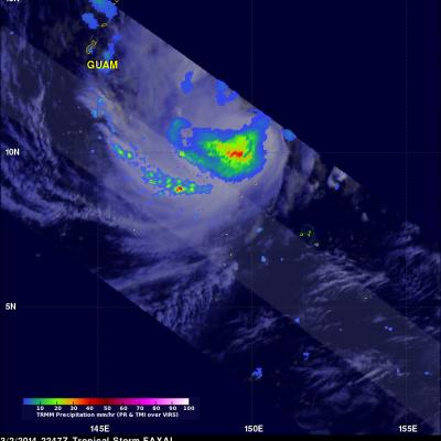
Tropical Storm Cristina

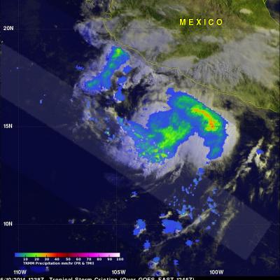
The third tropical depression of the eastern Pacific Ocean was upgraded by the National Hurricane Center (NHC) to tropical storm Cristina on June 10, 2014 at 0300 UTC (8 PM PDT). The TRMM satellite had a good early morning view of Cristina on June 10, 2014 at 1238 UTC (5:38 AM PDT). Rainfall from TRMM's Microwave Imager (TMI) and Precipitation Radar (PR) are shown overlaid on an enhanced visible/infrared 1245 UTC image from the GOES-EAST satellite. TRMM TMI data show Large areas of moderate to heavy rainfall west of Mexico's coast. The NHC predicts that Cristina will strengthen to hurricane

Tropical Depression Jack

Tropical cylone Jack had weakened to a tropical depression when the TRMM satellite passed above on April 22, 2014 at 1120 UTC capturing data used in the images above. The approximate location of JACK's center is shown as a red circle. Almost all rainfall near the the tropical cyclone's center had ceased but TRMM PR found that Jack was producing rain at a rate of over 130mm/hr (about 5.1 inches) in outer bands.

Tropical Disturbance Adds Rain To Philippines

On April 21, 2014 at 2219 UTC the TRMM flew over stormy weather within a tropical disturbance near the Philippines. Precipitation from this tropical low adds to above normal rainfall for the Philippines during the past 30 days. Heavy rainfall with the slow moving remnants of tropical depression Peipah caused flooding in the Philippines earlier this month. TRMM's Precipitation Radar data were used to make a 3-D vertical slice through the tallest thunderstorm towers in this area of stormy weather. This slice shows that some storms were returning radar reflectivity values of greater than 52dBZ

Gillian's Persistent Remnants

The persistent remnants of tropical cyclone GILLIAN have moved westward over 2700km (about 1674 miles) since forming in the Gulf Of Carpentaria on March 8, 2014. GILLIAN's coherent remnants were located just to the southeast of the Indonesian island of Java when the TRMM satellite flew over on March 20, 2014 at 0415 UTC. TRMM's Precipitation Radar (PR) instrument revealed that intense convective storms in this area were still dropping rain at a rate of over 97 mm/hr (about 3.8 inches) and returning radar reflectivity values of over 51dBZ. TRMM PR data were used in the simulated 3-D view on the

Tropical Storm Faxai

Tropical storm FAXAI meandered in a area southeast of Guam for the past few days and is now predicted to move toward the north passing well to the east of Guam. The TRMM satellite had a good daytime view of the tropical storm on March 2, 2247 UTC. TRMM's Microwave Imager (TMI) and Precipitation Radar (PR) data revealed that FAXAI had heavy rain falling at a rate of over 89 mm/hr (~3.5 inches). A few rainshowers from FAXAI are shown affecting GUAM.

Tropical Storm Dylan (ELEVEN) Heads Toward Queensland

Tropical storm Dylan was heading from the Coral Sea toward Australia's Queensland coast when it was viewed by the TRMM satellite on January 30, 2014 at 0214 UTC. The rainfall analysis above used data collected by TRMM's Microwave Imager (TMI) and Precipitation Radar (PR) instruments. Rainfall is shown overlaid on an enhanced visible/infrared image from TRMM's Visible and InfraRed Scanner (VIRS). TRMM's TMI data revealed that moderate to heavy rain falling at a rate of over 31 mm/hr (about 1.2 inches) was preceding Dylan's movement toward the Australian coast. Dylan's approximate past and

Tropical Cyclone Alessia Soaks Northern Australia

During the past weekend tropical cyclone ALESSIA weakened to a tropical low as it moved from the Timor Sea over Northern Australia. The warm waters of the Gulf Of Capentaria have helped revive ALESSIA to tropical storm intensity today. The image on the right shows TRMM satellite data collected on November 27, 2013 at 0225 UTC. A 3-D perspective view (from the west) shows the tropical cyclone's vertical structure based on radar reflectivity data collected by TRMM's Precipitation Radar (PR) instrument. Thunderstorm towers are shown reaching heights above 16km (~9.92 miles) in a feeder band east

Morning View of Tropical Storm Melissa

The TRMM satellite passed directly above tropical storm Melissa's center of circulation on November 20, 2013 at 1121 UTC (6:21 EST). TRMM's Precipitation Radar (PR) instrument found that rain was falling at a maximum rate of 55 mm/hr (~2.2 inches) in an area just to the southeast of Melissa's center of circulation. TRMM Precipitation Radar data were also used in the image on the right to show Melissa's 3-D structure. The tallest towers, reaching heights of over 13km (~8 km), were located in a band of rainfall to the northwest of Melissa's center. The strongest intensity radar echo of over

TRMM Views New Tropical Storm Melissa

The TRMM satellite flew above recently formed subtropical storm MELISSA in the central Atlantic Ocean on November 18, 2013 at 1449 UTC (9:49 AM EST). The image above shows rainfall data from TRMM's Microwave Imager (TMI) and Precipitation Radar (PR) overlaid on an enhanced visible/infrared image from TRMM's Visible and InfraRed Scanner (VIRS). This TRMM pass found that the heaviest rainfall within MELISSA was falling at a rate of over 74mm/hr (~2.9 inches) in an area of strong convective rainfall that was wrapping around the southern side of the storm. The National Hurricane Center (NHC)

Haiyan and Tropical Storm 30 Bring Heavy Rains to the Philippines

Super typhoon Haiyan, known locally in the Philippines as Yulonda, will go down as a historic storm, making landfall in the central Philippines as perhaps the most powerful tropical cyclone to ever make landfall with sustained winds estimated at 195 mph (~315 kph). So far, over 2300 people are confirmed to have been killed by the storm, and the number is likely to climb higher with many still missing and not all areas unaccounted for. Katrina, which devasted the US Gulf coast in 2005, was responsible for 1833 fatalities The most deadly flooding from Super Typhoon Haiyan was caused by the storm