tropical storms

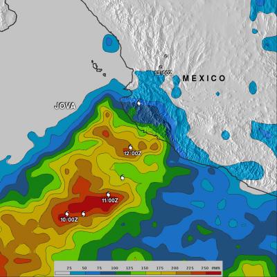
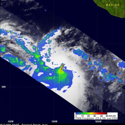
Tropical Depression Near Oman Dissipates

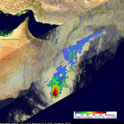
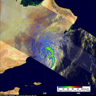
The Joint Typhoon Warning Center (JTWC) issued it's last warning on dissipating tropical depression 04W in the Arabian Sea on 9 November 2011 at 1500 UTC. A rainfall analysis from TRMM data collected with a pass over 04A on 9 November 2011 at 1530 UTC is shown here. Data from TRMM's Microwave Imager (TMI) and Precipitation Radar (PR) show that heavy rainfall was extending from 04A's location in the Arabian Sea north-eastward toward Pakistan.

TRMM Views Deadly Storm

Tropical storm Kelia caused the reported deaths of at least 11 people when it came ashore in Oman on Thursday 3 November 2011. TRMM's Microwave Imager (TMI) had a good early morning view of Keila on 3 November 2011 at 0254 UTC. The TMI rainfall analysis from these data was overlaid on a sunlit visible and infrared image from TRMM's Visible and InfraRed Scanner (VIRS). This rainfall analysis shows a large band of moderate to heavy rainfall wrapping around the eastern side of the storm and drenching coastal Oman.

TRMM Sees Weakening Tropical Storm Keila

The TRMM satellite again flew over tropical storm Keila in the Arabian Sea on November 2, 2011 at 1842 UTC. Data received with that orbit shows that although Keila was weakening it was still producing some very powerful storms off the coast of Oman. A rainfall analysis from TRMM's Microwave Imager (TMI) and Precipitation Radar (PR) indicates that these storms were dropping rain at a rate of over 50mm/hr (~2 inches). TRMM PR data were used in the image above to show the 3-D vertical structure of those storms. Some extremely powerful storms in the band of rainfall off the coast of Oman were

Tropical Storm Keila In The Arabian Sea

The TRMM satellite passed directly above a recently formed tropical cyclone in the Arabian Sea on November 2, 2011 at 0350 UTC. An analysis of rainfall from TRMM's Microwave Imager (TMI) and Precipitation Radar (PR) instruments is shown in the image on the upper left. TRMM data shows that rainfall rates with tropical storm Keila ranged from light to moderate along the south-eastern coast of Oman. Moderate to heavy rainfall was revealed to be spiraling into Keila's center of circulation in the Arabian Sea near the southeastern coast of Oman. The image above is a rendering that shows Keila's

TRMM Sees Tropical Storm Rina Forming

The National Hurricane Center (NHC) upgraded an area of disturbed weather in the Caribbean to tropical depression eighteen and then to tropical storm Rina on 23 October 2011. The TRMM satellite flew over the forming tropical cyclone on 23 October 2011 at 1728 UTC (1:28 PM EDT). Data from TRMM's Microwave Imager (TMI) and Precipitation Radar (PR) showed that the future storm already was well organized and had a large area of heavy rainfall extending toward the northeast from eastern Honduras.

Tropical Systems bring Heavy Rain to Mexico and Central America

Within just the past week, the East Pacific has seen a resurgence in tropical activity with the formation of three tropical systems: two hurricanes and a depression. Two of the systems, the two that would go on to become hurricanes, formed on the evening and night of 5 October 2011. The first was TD #10E, the 10th tropical depression of the season in the East Pacific. It formed about 1000 km (~625 mi) south of the Mexican coast and later strengthened into Hurricane Jova. Jova intensified to a Category 3 hurricane before eventually making landfall as a Category 2 storm on Wednesday October 12th

Tropical Storm Jova a Possible Threat to Mexico

Two tropical cyclones called Irwin and Jova have developed in the eastern Pacific southwest of Mexico. The TRMM satellite traveled above tropical storm Jova on 7 October 2011 at 0413 UTC collecting data used in the images above. Jova is predicted to become a hurricane on the morning of 8 October and move northeastward toward the Mexican coast. TRMM's Precipitation Radar (PR) data, shown above, reveals that Jova had a cluster of very powerful thunderstorms near the center of the intensifying storm. Some of these thunderstorms were reaching to heights of over 17 km (~10.6 miles).

Philippe's Strength Persists

Philippe was still a tropical storm when the TRMM satellite passed above on 3 October 2011 at 1806 UTC (2:06 PM EDT) but the National Hurricane Center (NHC) predicts that the storm may become a hurricane in a couple days. TRMM's TMI and PR data show that bands of powerful convective thunderstorms were still dropping rain at a rate of over 50mm/hr (~2 inches) near the center of the storm.

Tropical Storm Philippe Shows Signs Of Life

Tropical Storm Philippe, located in the central Atlantic Ocean, has shown signs of strengthening. The TRMM satellite obtained those data used in the above image when it passed over on 2 October 2011 at 1902 UTC ( 3:02 PM EDT). TRMM's Microwave Imager (TMI) and Precipitation Radar (PR) derived rainfall showed that Philippe had powerful thunderstorms in the north-central part of the storm dropping rainfall at a rate over 50 mm/hr (~2 inches). TRMM's PR was used in the image below show a vertical cross section (slice) through one of these thunderstorms. This image shows that one of these tall

Ophelia Reviving and Philippe Weakening

The TRMM satellite passed above two tropical cyclones in the Atlantic Ocean early today. Tropical storm Philippe was seen at 0358 UTC (12:58 PM EDT 26 September 2011) and the regenerating remnants of tropical storm Ophelia were observed at 0529 UTC ( 1:29 AM EDT). TRMM's Precipitation Radar (PR) data were used in these images above to show the vertical structure of both storms. The image above used PR data to show that powerful thunderstorm towers were reaching to heights of over 15km (~9.3 miles) in the center of the increasingly better organized Ophelia remnants. Tropical storm Philippe on