tropical storms

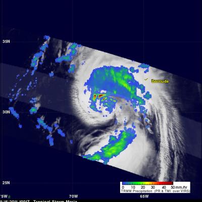
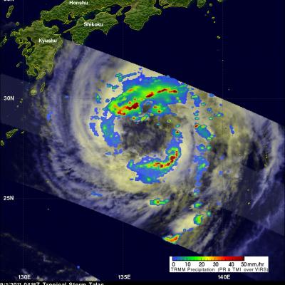
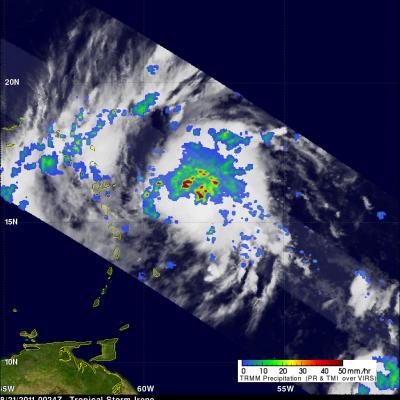
Tropical Storm Ophelia Forms

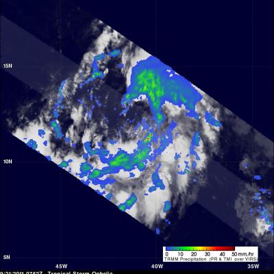
The TRMM satellite passed over newly formed tropical storm Ophelia in the Atlantic Ocean on September 2011 at 0752 UTC ( 4:52 AM EDT). TRMM shows that Ophelia isn't very well organized and contains only a few scattered areas of heavy rainfall. The National Hurricane Center (NHC) has predicted that Ophelia will remain a tropical storm with wind speeds reaching a maximum of 50 kts (~58 mph).

Maria Moving to the West of Bermuda

The TRMM satellite traveled above tropical storm Maria on Thursday 15 September 2011 at 1001 UTC ( 6:01 AM EDT). Maria's organization had improved over that seen by TRMM earlier in the week due to favorable (warmer) sea surface temperatures and lower upper level wind shear. A rainfall analysis from TRMM's Precipitation Radar (PR), displayed in a lighter swath, shows that powerful convective storms were dropping rainfall at a rate of over 50mm/hr (~2 inches) northwest of Maria's center of circulation. A large area of rainfall containing bands of heavier rainfall was also shown by TRMM's

TRMM Sees Disorganized Tropical Storm Maria

The TRMM satellite passed over tropical storm Maria on 12 September 2011 at 1249 UTC (8:49 AM EDT). This TRMM pass shows that tropical storm Maria's center of circulation was exposed and displaced well to the west of deep convection. A red tropical storm symbol was overlaid on the image derived from this TRMM pass to show the location of Maria's center of circulation. With this pass TRMM's Precipitation Radar (PR), shown in the lighter swath, scanned directly above the deep convection east of Maria's center. Those data showed that some rainfall in this area was very intense with rates of over

Tropical Storm Lee Joins with Frontal System to Soak the Eastern US

After forming in the north central Gulf of Mexico, Tropical Storm Lee came ashore over south central Louisiana on the morning of Sunday September 4th, 2011. Over the next two and a half days, the slow-moving storm worked its way across central Louisiana and central Mississippi and into northern Alabama, dumping heavy rains along the way. The primary mission of the Tropical Rainfall Measuring Mission or TRMM satellite is to measure rainfall over the global Tropics using a combination of passive microwave and active radar sensors. For expanded coverage, TRMM can be used to calibrate rainfall

TRMM Sees Developing Tropical Storm Nate

The TRMM satellite flew over the latest tropical cyclone to form in the Atlantic Ocean basin on 7 September 2011 at 1812 UTC (2:12 PM EDT). This TRMM pass was a few hours before the National Hurricane Center (NHC) named this low pressure center in the Bay Of Campeche tropical storm Nate. Data from TRMM's Precipitation Radar (PR) shows that the forming tropical cyclone had areas of heavy convection with storm tops reaching to heights of about 14km (~8.7 miles) south of Nate's center of circulation.

Extreme Rainfall from Tropical Storm Lee

The rainfall analysis above is from TRMM calibrated precipitation estimates called Multi-satellite Precipitation Analysis (MPA). This product was developed by the precipitation research team in the Laboratory for Atmospheres at NASA Goddard Space Flight Center and uses satellite data collected in "real time"(3B42 ). This preliminary analysis shows the estimated total rainfall measured for the period from 30 August to 6 September 2011 and includes rainfall from other sources including tropical storm Lee. Tropical storm Lee has been dropping heavy rain since moving over land from the Gulf Of

Tropical Storm Talas Approaches Japan

Tropical storm Talas was seen by the TRMM satellite approaching the main islands of Japan on 1 September 2011 at 0416UTC (~1:15 PM local time). This daylight TRMM pass shows that Talas had a very large nearly clear eye with large bands of intense thunderstorms located far from the storm's center. Talas is predicted travel over the main islands of japan in the next 36 hours.

Tropical Storm Katia Takes Shape in the Atlantic

While parts of the East Coast and New England are still recovering from Hurricane Irene, a new storm is brewing in the Atlantic, Tropical Storm Katia. Katia began as an area of low pressure that had moved away from the coast of Africa south of the Cape Verde Islands in the central eastern Atlantic. This area of low pressure became the twelfth tropical depression of the season (TD #12) early on the morning of August 29th about 640 km (~400 miles) south-southwest of the Cape Verde Islands and about 1400 km (~870 miles) off the coast of Africa. Storms forming in this region are known as "Cape

Harvey Dropped Heavy Rain In Some Areas

Tropical storm Harvey is dissipating inland over southern Mexico while hurricane Irene is drenching the island of Puerto Rico. Harvey's track is shown on the rainfall analysis above with appropriate tropical cyclone symbols in white. The TRMM-based, near-real time Multi-satellite Precipitation Analysis (TMPA) at the NASA Goddard Space Flight Center provides quantitative rainfall estimates over the global tropics. An analysis of TMPA rainfall totals for the period August 15-22, 2011 is shown for the area transited by tropical storm Harvey. The highest rainfall total associated with Harvey was

Tropical Storm Irene Forms

The National Hurricane Center (NHC) issued it's first advisory for tropical storm Irene on 20 August 2011 at 2300 UTC (7 PM EDT). The TRMM satellite passed over the intensifying storm a little later on 22 August 2011 at 0024 UTC (8:24 PM EDT). Data collected with this orbit showed that Irene contained numerous powerful thunderstorms with TRMM's Precipitation Radar (PR) revealing that some thunderstorm towers near the center of the storm were reaching to heights above 15 km (~9.3 miles). The NHC has forecasted that Irene will become a hurricane within 36 hours while moving in a west