tropical storms

Tropical Storm Koji

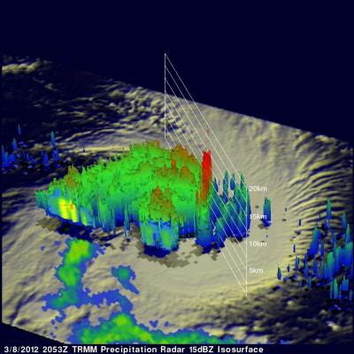
The TRMM satellite passed directly above an intensifying tropical storm in the South Indian Ocean called KOJI on 8 March 2012 at 2053 UTC. The rainfall analysis above was made from TRMM Microwave Imager (TMI) and Precipitation Radar (PR) data. Those TRMM data reveal that KOJI was getting organized with bands of heavy rainfall spiraling into the storm's center. KOJI has been predicted to increase in intensity and reach hurricane force with peak winds of 70kts (~80 mph) on 10 March 2012. KOJI is predicted to remain at hurricane force for only one day and then weaken while traveling southwestward

TRMM Sees Tropical Storm Heidi

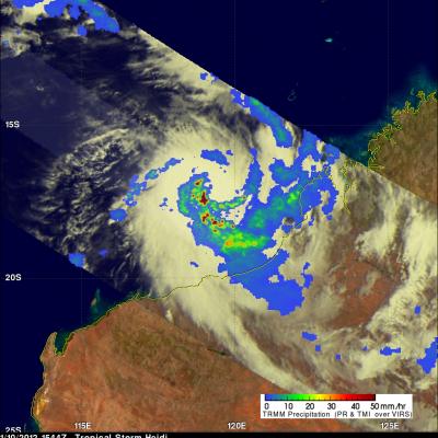
On 10 January 2012 at 1544 UTC the TRMM satellite passed above tropical storm Heidi as it was forming off the northwestern coast of Australia. Heidi is the first named tropical cyclone to hit Australia this season. An analysis of rainfall from TRMM Microwave Imager (TMI) and Precipitation Radar (PR) data is shown above. This analysis shows that Heidi was starting to get organized with bands of heavy convective rainfall spiraling toward the center of the storm. Heidi was dropping rainfall at a rate of over 50mm/hr (~2 inches) in some areas. A 3-D image above was made from TRMM PR data. It shows

TRMM Sees Tropical Storm Striking Madagascar

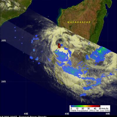
The TRMM satellite has been collecting data that improves understanding of rainfall in the tropics since it's launch in 1997. The satellite also provides timely data about the development of tropical cyclones. One of these tropical cyclones called Chanda was hitting the coast of Madagascar when TRMM saw it on 8 January 2012 at 2213 UTC. A red tropical storm symbol is shown at Chandra's approximate location. Data from TRMM's Precipitation Radar (PR) and Microwave Imager (TMI) instruments shows that Chanda was dropping light to moderate rainfall over large areas of southern Madagascar. Deadly

Tropical Storm Washi (27W) Strengthens

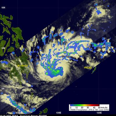
As expected tropical storm Washi (27W) had strengthened when the TRMM satellite passed over on 15 December 2011 at 1515 UTC collecting data used in the rainfall analysis shown above. TRMM Microwave Imager (TMI) and Precipitation Radar (PR) data are shown overlaid on an enhanced infrared image from the satellite's Visible and InfraRed Scanner (VIRS). This rainfall analysis shows that Washi was much better organized with very heavy rainfall of over 50mm/hr (~2 inches) revealed by TRMM PR within bands spiraling into the center of the storm. The 3-D image above used Precipitation Radar data from

TRMM Sees Powerful Tropical Cyclone Alenga

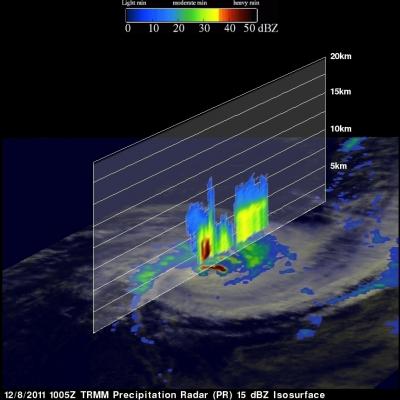
Tropical Cyclone Alenga's wind speeds increased to a maximum of about 90kts (~104 mph). Alenga had weakened from this maximum intensity when the TRMM satellite passed directly above in the early evening of 8 December 2011 at 1005 UTC. A precipitation analysis from TRMM's Microwave Imager (TMI) and Precipitation Radar (PR) are shown above overlaid on a Visible/Infrared image from Visible and InfraRed Scanner (VIRS) data. This analysis shows that very heavy rainfall of over 50 mm/hr (~2 inches) was being produced by intense storms in Alenga's eye wall. The image below shows a 3-D vertical slice

Tropical Storm Alenga Intensifies

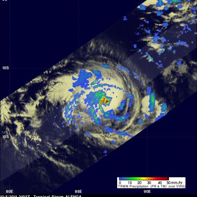
The TRMM satellite again passed over intensifying tropical storm Alenga in the South Indian Ocean on 5 December 2011 at 2103 UTC. As expected Alenga had become better organized with TRMM's Precipitation Radar (PR) seeing scattered bands of heavy rainfall spiraling into the center of the storm. Alenga is expected to move south-eastward over the open waters of the South Indian Ocean and reach minimal hurricane force on 7 December 2011. A 3-D image using TRMM PR is shown above. Very powerful storms are shown reaching heights of about 16 km (~9.9 miles). TRMM PR found a reflectivity value of 53.67

TRMM Sees First Tropical Storm Forming In The South Indian Ocean

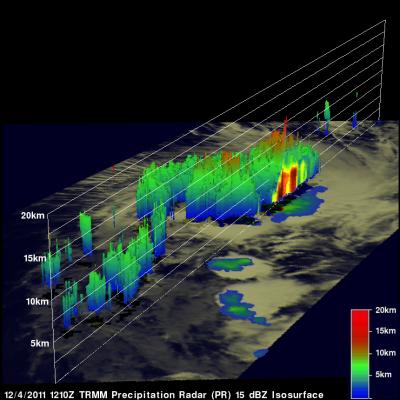
On 4 December 2011 at 1210 UTC The TRMM satellite had a look at the first tropical storm forming in the Indian Ocean this season. Tropical cyclones normally form in this area between 15 November and 30 April so this one was a little overdue. The "top down" view above shows a rainfall analysis from TRMM Microwave Imager (TMI) and Precipitation Radar (PR) overlaid on an enhanced infrared image from Visible and InfraRed Scanner (VIRS) data. This analysis shows that very heavy rainfall of over 50 mm/hr (~2 inches) was occurring in the forming tropical cyclone near the center of it's circulation

Tropical Storm in the Arabian Sea

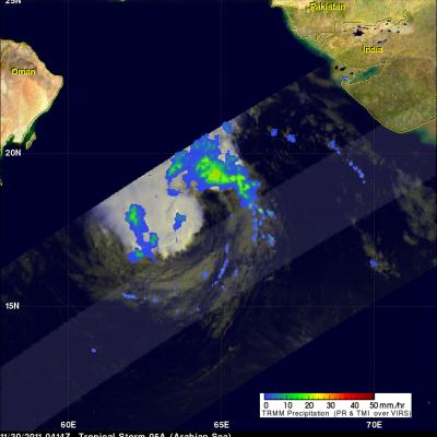
Tropical Storm 05A, the 5th of the season in the North Indian Ocean, has been steadily making it's way northwestward across the Arabian Sea over the past few days but is now expected to weaken, reducing the threat to Oman, southern Iran and Pakistan. The storm formed back on November 26th in the North Indian Ocean about 170 km (~105 miles) west of the southern tip of India and has maintained the same minimal tropical storm intensity with sustained winds of around 35 knots (~40 mph) while moving steadily to the northwest into the central Arabian Sea. The Tropical Rainfall Measuring Mission

Tropical Storm Kenneth

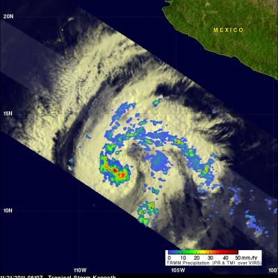
The TRMM satellite had a good view of tropical storm Kenneth in the eastern Pacific Ocean when it passed above on 21 November 2011 at 0510 UTC (20 November 2011 9:10 PM PST). The National Hurricane Center (NHC) upgraded Kenneth to a hurricane on 21 November 2011 at 1500 UTC (7:00 AM PST) after determining that a ragged eye was forming. The image on the right shows a rainfall analysis derived from TRMM's Microwave Imager (TMI) and Precipitation Radar (PR) instruments. TMI data show that heavy rainfall was occurring around the center of Kenneth's circulation.

TRMM PR Slices Through Sean

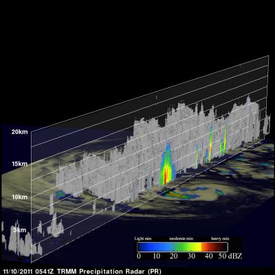
The TRMM satellite had a good look at tropical storm Sean when it flew over on 10 November 2011 at 0541 UTC (00:41 AM EST). TRMM's Precipitation Radar (PR) data were used in the image above to show a 3-D cross section through Sean. TRMM's PR revealed that heights of storms in the edge of Sean's center of circulation were reaching to about 11km (~6.8 miles). Radar Reflectivity values of up to 46.0 dBZ found in these storms also showed that rainfall was heavy in that area. The "top down" satellite view above shows that those storms in Sean's northwestern quadrant were the most powerful. The rest