Typhoon

Typhoon Haima Hits China After Devastating The Northern Philippines JacobAdmin Tue, 10/25/2016
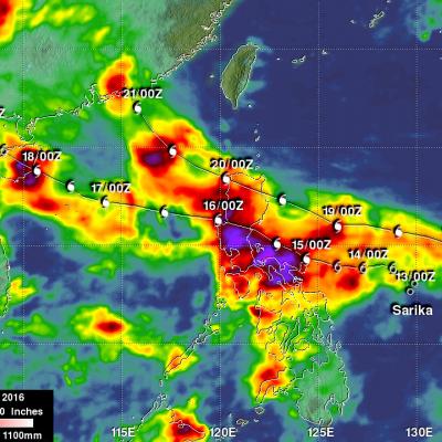
After Haima's caused extensive destruction and at least 13 deaths in the northern Philippines the typhoon traveled across the South China Sea to batter Hong Kong and mainland China. Heavy rain and gusty winds accompanied Haima as the typhoon passed to the east of Hong Kong. Operations at Hong Kong's international airport were nearly stopped by the typhoon. At least one person was reported killed in Hong Kong. Haima made landfall in China 110 km (68 miles) east of Hong Kong at about 0400 UTC (noon CST). Haima's winds were decreasing and the typhoon was the equivalent of a category one hurricane
Super Typhoon Usagi Threatens The Philippines and Taiwan JacobAdmin Mon, 09/23/2013
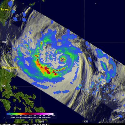
The most powerful typhoon of 2013 may affect the northern Philippines and southern Taiwan. What is now super typhoon USAGI formed in the open waters of the Philippine Sea about 1,000 km (~620 miles) east of the Philippines on September 16, 2013. USAGI rapidly intensified and became a typhoon yesterday. Super Typhoon USAGI had estimated maximum winds of close to 140kts (~161 mph) when the TRMM satellite had an excellent view on September 19, 2013 at 1035 UTC. A precipitation analysis from TRMM's Microwave Imager (TMI) and Precipitation Radar (PR) instruments is shown on the left overlaid on an

Weaker Typhoon Soulik Heads Towards Taiwan

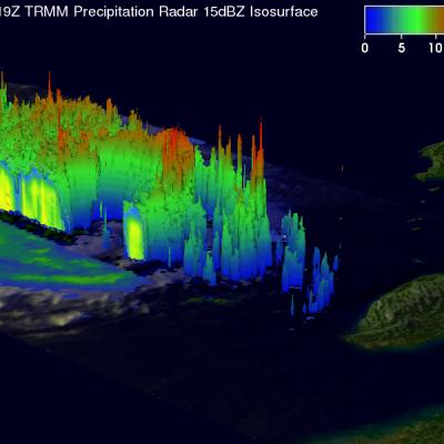
TRMM satellite again flew above weakening typhoon Soulik on July 11, 2013 at 2119 UTC. Data from TRMM's Microwave Imager (TMI) and Precipitation Radar (PR) instruments show that Soulik had weakened considerably. The eye diameter was shown to be much greater than when TRMM passed over super typhoon Soulik about 7 hours earlier. This TRMM Precipitation Radar 3-D view (from the northwest) shows typhoon Soulik east of Taiwan. The structure of Soulik's large eye is clearly shown by this TRMM PR slice through the weakening typhoon. Soulik is predicted by the Joint Typhoon Warning Center (JTWC) to be

TRMM Sees Powerful Typhoon MA-ON

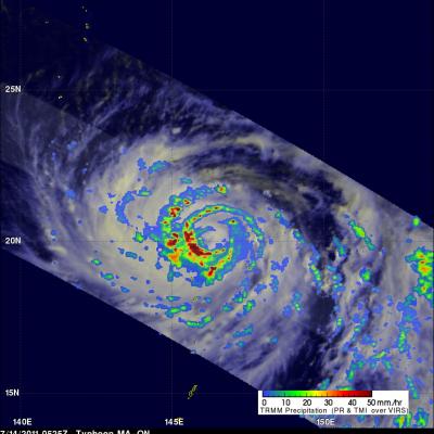
The TRMM satellite passed almost directly above powerful typhoon MA-ON on 14 July 2011 at 0525 UTC. This TRMM orbit revealed that MA-ON was extremely well organized with several bands of intense thunderstorms around a well defined eye. This rainfall analysis, using data from TRMM's Microwave Imager (TMI) and Precipitation Radar (PR), shows that the heaviest rainfall of over 50 mm/hr (~ 2 inches) was located in the southwestern quadrant of MA-ON's eye wall. MA-ON is predicted to become an even more dangerous super typhoon with wind speeds of 135 kts (155 mph) on 17 July 2011 while approaching

Songda becomes a Super Typhoon

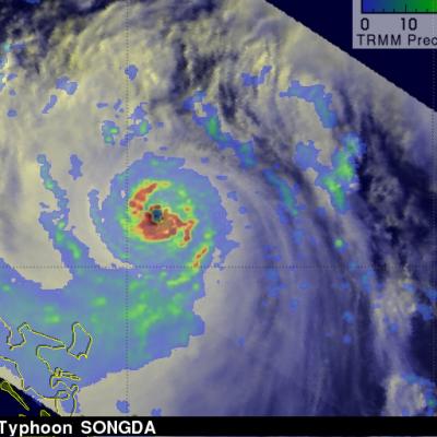
As predicted, Typhoon Songda intensified and was a super typhoon with wind speeds estimated at over 130 kts ( ~145 mph) when the TRMM satellite passed directly over head on 26 May 2011 at 0806 UTC. The image above used data from TRMM's Visible and InfraRed Scanner (VIRS) and a TRMM rainfall analysis . The rainfall analysis from TRMM's Microwave Imager (TMI) and Precipitation Radar (PR) data shows that Songda had a circular eye with extremely heavy rainfall, particularly in the southeast quadrant. TRMM's PR data shows the concentric rain bands typical of powerful typhoons. Below is a simulated

TRMM Sees Typhoon Songda

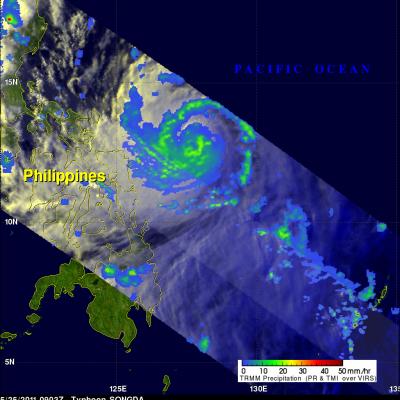
Typhoon Songda was east of the Philippines when the TRMM satellite had an early evening view on 25 May 2011 at 0903 UTC. Both TRMM's Microwave Imager (TMI) and Precipitation Radar (PR) instruments were used to provide the rainfall analysis shown above. TRMM's TMI had the best coverage of rainfall with Songda and showed well organized bands of moderate to heavy rainfall converging into the typhoon. Songda was an intensifying category 3 typhoon, on the Saffir-Simpson scale, with wind speeds of over 105 kts (~121 mph) at that time. Songda is predicted to become a very powerful category 4 super