US South

GPM Satellite Examines Tornadic Thunderstorms

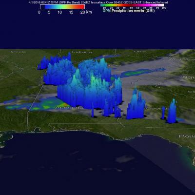
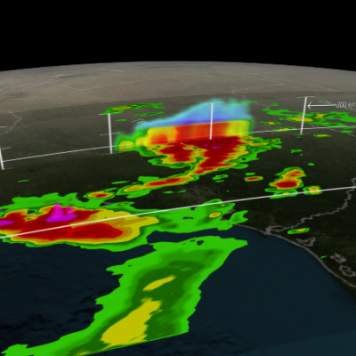
Over the past few days tornado spawning thunderstorms have occurred in the states of Texas, Oklahoma, Arkansas, Louisiana, Indiana, Mississippi, Alabama and Georgia. Large hail, damaging winds, and flash flooding associated with a frontal system moving across the United States have compounded the damage from these storms. Hail the size of a half-dollar was reported near Jackson, Louisiana on Thursday evening. The GPM core observatory satellite flew over this stormy area on April 1, 2016 at 0241 UTC (March 31, 2016 at 10:41 PM EDT). Tornadoes were reported in Mississippi, Alabama and Georgia

Torrential Rain Over South Measured From Space

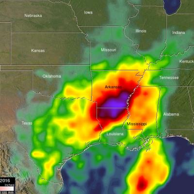
Extremely heavy rain fell over the southern United States during the past week. A slow moving area of low pressure pumped moisture from the Gulf Of Mexico causing torrential rain that resulted in wide spread flooding in states from Texas to Tennessee. Over 24 inches of rain was reported in Monroe, Louisiana. Over 4,958 homes in Louisiana were reportedly damaged by the flooding. Strong winds accompanying intense thunderstorms also toppled trees in Mississippi and Louisiana. A simulated 3-D animation of NASA merged satellite rainfall analysis (TMPA) using data collected from March 7-14, 2016
Rainfall Floods the Mississippi River
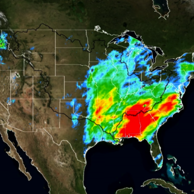
A series of winter storms brought more than 20 inches of rainfall to the Midwest and southeastern United States in December 2015. Massive flooding followed throughout both the regions. An animation of rainfall data from those storms was created at NASA's Goddard Space Flight Center in Greenbelt, Maryland. This animation shows the accumulation of rainfall over the United Stated during December 2015, from the IMERG precipitation dataset. The black outline indicates the Mississippi-Missouri River basin. This version has been edited to only show the periods of significant rainfall during the month...

NASA Looks At Deadly Weather Over the US

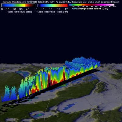
Heavy rainfall, flooding and tornado outbreaks affected areas of the United States from the Southwest through the Midwest from December 23-27, 2015. Tornadoes and flooding events killed at least 43 people during this period. Fourteen deaths alone occurred with tornadoes that hit Benton, Mississippi on December 23, 2015. Tornadoes are expected in the springtime but are much less frequent during this time of the year. An analysis was made of the rainfall that occurred during the period from December 21-28, 2015. This analysis used data generated by NASA's Integrated Multi-satellitE Retrievals
GPM Sees Tropical Storm Bill Over Texas
Download in hi-res from the NASA Goddard Scientific Visualization Studio Tropical Storm Bill made landfall over Texas at approximately 11:45am CST on June 16, 2015. Shortly after midnight, GPM passed over the storm as it slowly worked it's way northward across the already drenched state of Texas. This visualization shows Bill at precisely 12:11:27am CST (6:11:27 GMT) on June 17, 2015. The GPM Core Observatory carries two instruments that show the location and intensity of rain and snow, which defines a crucial part of the storm structure – and how it will behave. The GPM Microwave Imager sees...
TRMM Sees Flooding Rainfall Along Gulf JacobAdmin Tue, 06/12/2012
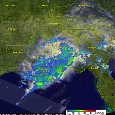
The states along the coast of the Gulf of Mexico experienced very heavy rainfall on Saturday June 9,2012 and Sunday June 10, 2012. The images above use TRMM satellite data collected when it flew over on Sunday June 10, 2012. Unusually heavy rainfall was occurring in states near the Gulf coast. Due to the path of TRMM's orbits it had good coverage with more than one orbit. The first orbit occurred at 1501 UTC (11:01 AM EDT). The second image shows a combination of more than one orbit with the later data being collected at about 1817 UTC (2:17 PM EDT). TRMM rainfall analyses from these orbits