GPM

Content which is affiliated solely with the Global Precipitation Measurement Mission.

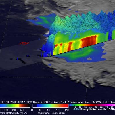
GPM Probes Powerful Tropical Cyclone Cebile

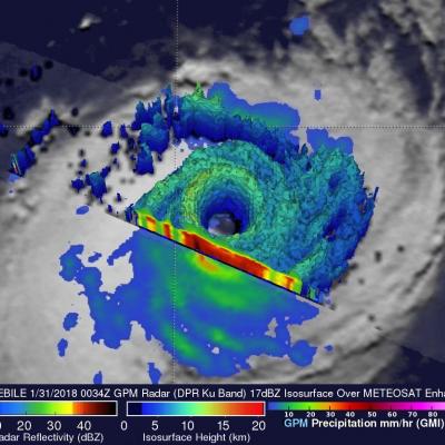
Tropical Cyclone CEBILE formed four days ago in the southwest Indian Ocean southeast of Diego Garcia. Today CEBILE became the most powerful tropical cyclone to form in the southern hemisphere this year. Maximum sustained wind speeds within CEBILE were estimated at 120kts (138 mph) early today making CEBILE the equivalent of a category 4 hurricane on the Saffir-Simpson hurricane wind scale. The GPM core observatory satellite passed directly above the well defined circular eye of tropical cyclone CEBILE on January 31, 2018 at 0034 UTC. Rainfall intensity and coverage within CEBILE were revealed

GPM Views Sheared Tropical Cyclone Fehi

The GPM core observatory satellite flew tropical cyclone FEHI on January 30, 2018 at 0831 UTC. GPM revealed that precipitation was only located around the southern side of FEHI's circulation. Strong vertical wind shear had caused the surface center of circulation (shown with a red symbol) to be displaced well to the north of the heaviest rainfall. The satellite found that some convective storms on the southern side of the tropical cyclone were still producing very heavy precipitation. GPM's Microwave Imager (GMI) and Dual Frequency Precipitation Radar (DPR) instruments revealed rainfall in a

IMERG V05B Retrospective Processing and SAPHIR precipitation

Effective 27 January 2018 all the IMERG Early products have a retrospective V05B processing for the entire GPM mission starting in March 2014. All V04 products have been saved in a V04 directory. V03 products are no longer available. Effective 27 January 2018 IMERG Late products have a retrospective V05B processing from the beginning of the mission in March 2014 to January 2017. We continue to process Late products and they should be completed in another week. We are also working on retrospective processing to V05B of the GIS friendly TIFF IMERG based products. These should all be at V05B in

GPM Sees Tropical Cyclone Berguitta Battering Mauritius

Tropical cyclone BERGUITTA was moving very close to the eastern side of the island of Mauritius when the GPM core observatory satellite passed above on January 18, 2018 at 0528Z (9:28 AM local time). This meant that the most destructive section of tropical cyclone BERGUITTA was passing very close to the eastern side of Mauritius. For this reason the eastern side of Mauritius would be expected to have had the highest winds, seas, and storm surge from BERGUITTA. The tropical cyclone was passing a little farther to the east of the island of Reunion. Data collected by GPM's Microwave Imager (GMI)

GPM Sees Tropical Cyclone Berguitta Bearing Down On Mauritius

The GPM core observatory satellite passed over the southwest Indian Ocean on January 16, 2018 at 1856 UTC. GPM showed that heavy rainfall within tropical cyclone BERGUITTA was moving closer to the islands of Reunion and Mauritius. GPM's Microwave Imager (GMI) and Dual Frequency Precipitation Radar (DPR) instruments found that powerful storms northeast of Mauritius were dropping rain at a rate greater than 54 mm (2.1 inches) per hour. A 3-D view of Storm top heights within tropical cyclone BERGUITTA was made possible with GPM's radar (DPR ku Band). Those 3-D scans through the eastern side of

IMERG Reveals Rainfall Rates With Tropical Cyclone Berguitta

Tropical cyclone BERGUITTA formed in the southwestern Indian Ocean northeast of the islands of La Reunion and Mauritius on January 12, 2018. BERGUITTA is now moving toward the southwest and threatening the islands. Early on January 16,2018 BERGUITTA had maximum sustained winds estimated at 100 kts (115 mph). This means that BERGUITTA was the equivalent of a category three hurricane on the Saffir-Simpson hurricane wind scale. Later in the day BERGUITTA's maximum sustained wind speeds were estimated at 85 kts (98 mph) with gust to 105 kts (121 mph). On January 16, 2018 at 1200Z tropical cyclone

Heavy Rainfall Leads To Deadly California Mudslides

Winter rains falling on recently burned ground triggered deadly mudslides near Santa Barbara, California on the 9th of January. The potential for landslides is shown above. It was generated by the global Landslide Hazard Assessment for Situational Awareness (LHASA) model, a model that combines GPM precipitation data with a global landslide susceptibility map. LHASA gives a broad overview of landslide hazard in nearly real time, but site-specific information should be obtained prior to emergency operations or building projects. At least 15 residents of southern California have been killed by

Tropical Cyclone Ava's Disastrous Rainfall Measured With IMERG

Tropical cyclone Ava dropped extremely heavy rainfall over Madagascar as it passed over the eastern side of the island country from January 5-6, 2018. Ava's drenching rainfall caused flooding and landslides which resulted in the deaths of at least 29 people. An estimated 80,000 people on Madagascar were affected by the tropical cyclone. This rainfall analysis was produced by accumulating rainfall that fell near Madagascar during the period from January 2-8, 2018. These IMERG estimates showed the locations of extreme rainfall totals during the period when tropical cyclone Ava was in Madagascar

Replacement GPM Ka/Ku L1B products (2017-12-31) for orbit 21819-21821

PPS received replacement GPM Ka/Ku L1B (21819-21821) products from JAXA and will reprocess the affected data including Level 2 and 3 data. If you have already obtained products with orbit# 21819-21821 from our archive or through a standing order, etc., please discard and use the replacement products. PPS has replaced the following GPM Ka/Ku L1B data: GPMCOR_KUR_1712310333_0505_021819_1BS_DUB_05A.h5 GPMCOR_KAR_1712310333_0505_021819_1BS_DAB_05A.h5 GPMCOR_KUR_1712310505_0638_021820_1BS_DUB_05A.h5 GPMCOR_KAR_1712310505_0638_021820_1BS_DAB_05A.h5 GPMCOR_KUR_1712310638_0810_021821_1BS_DUB_05A.h5