GPM's How-to Guide for Global Rain Maps
In a data-processing room at NASA’s Goddard Space Flight Center in Greenbelt, Maryland, racks of high-powered computers are making a set of maps. They're not the familiar satellite map of farms, forests and cities. Instead, the maps will show what's in the atmosphere above the ground -- falling rain and snow.
The data come from the Global Precipitation Measurement mission, an international partnership led by NASA and the Japan Aerospace Exploration Agency. The GPM Core Observatory launched on Feb. 27, 2014, and after an initial check-out period, began its prime mission on May 29. The data began flowing as soon as the two instruments were turned on, and have been released in stages, beginning with the most basic data from the satellite, made public in June, and progressing to more complex data sets of hourly and daily rain estimates over single orbits through the summer. On Sept. 2, all Core Observatory data sets were released to the public.
But the mission goes beyond data gathering from one satellite. Ten other spacecraft from U.S. agencies and other countries all carry an instrument similar to one of the two aboard the Core Observatory. In different orbits, together their precipitation data shows where precipitation is falling across the globe. Now, with GPM and the partner satellite data made public on Sept. 2, the pieces are coming together to begin producing a full multi-satellite network of rain data into a single global map updated every 30 minutes.
Compiling observations from these 11 sources and releasing them both individually and into one unified global data set is the job of the Precipitation Processing System at Goddard.
Image Credit: NASA's Goddard Space Flight Center/R. Fitzgibbons
Download this video in HD formats from NASA Goddard's Scientific Visualization Studio
The GPM Core Observatory satellite at the heart of the mission flies 253 miles (407 kilometers) above Earth's surface, collecting data from its two instruments. The Dual-frequency Precipitation Radar sends out active pulses of microwave energy that reflect off of ice and rain or snow particles within clouds. How the pulses return to the satellite carries information about where and what they encountered. The GPM Microwave Imager measures microwave energy, which rain and ice naturally emit. The data from each instrument are recorded as numbers -- instrument counts.
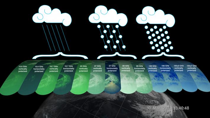
 The GPM Microwave Imager has 13 channels, each sensitive to different types of precipitation. Channels for heavy rain, mixed rain and snow, and snowfall are displayed of the extra-tropical cyclone observed March 10, off the coast of Japan. Multiple channels capture the full range of precipitation.
Image Credit: NASA/JAXA
More from NASA Goddard's Scientific Visualization Studio
"The PPS takes data that are, in essence, instrument counts and converts them to precipitation measurements: falling rain, snow and so on," said Erich Stocker, project manager of the PPS and GPM deputy project scientist for data at Goddard.
The numbers transmitted down from the instruments don't mean a whole lot to most people – even the scientists themselves, said George Huffman, GPM deputy project scientist and head of the multi-satellite product team for GPM. "What we really care about it is the precipitation. To make that happen we have to have the algorithms."
Algorithms are mathematical processes used by computer programs developed by the science team that relate what the satellite instruments measure to rain, snow and other precipitation observed throughout the cloud and actually felt on the ground. It's a huge group effort, said Huffman. To develop the algorithms, data are collected from current precipitation satellites, routine ground validation efforts, and focused field campaigns to capture the variety of rainfall and snowfall in different parts of the world.
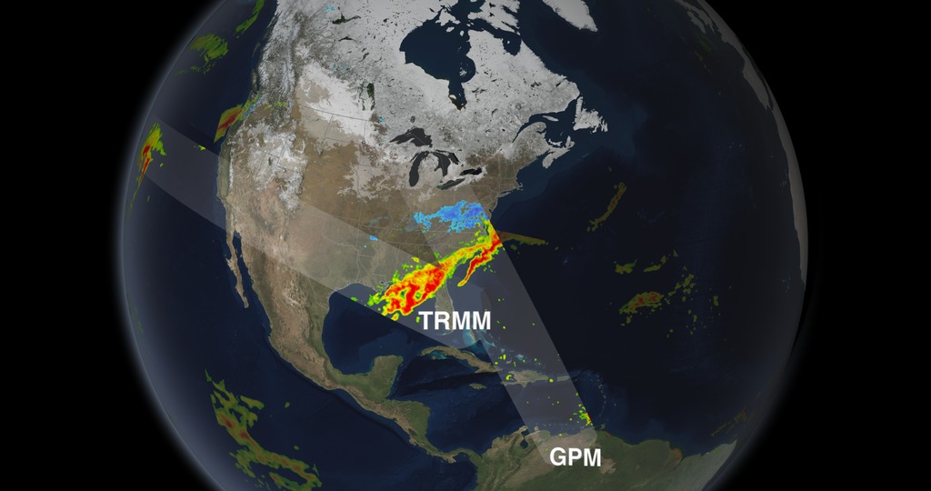
 This animation shows rain data collected by the GPM Core Observatory and the partner satellites currently in orbit on March 17, 2014. The end of the animation focuses in on a storm system that moved over the eastern United States. Th
Image Credit: NASA's Goddard Space Flight Center
Download HD-format animation from NASA Goddard's Scientific Visualization Studio
Once the computers process the raw data into precipitation information, Huffman and Stocker have a snapshot of the precipitation data – for example, one 90-minute orbit of the GPM Core satellite. But that's only for one swath of Earth under the GPM Core Observatory’s orbit – not a world map.
That's where the 10 other satellites measuring precipitation come in. They each have a different orbit than the GPM Core Observatory, allowing for multiple views of Earth that cover different portions of Earth’s surface at the same time. Data centers in five countries and three U.S. states each send the raw precipitation data from these additional satellites to the PPS, which combines them with the GPM Core Observatory's measurements to create a single map of rainfall data that covers 90 percent of the world over a short period of time.
It's kind of like making soup -- with raw data subbing for raw vegetables, Huffman said.
"They're all vegetables, and so you have to wash them, peel them, take out the bad spots -- that's a really important step, since you don't want your soup to taste bad," Huffman said.
"Maybe you sauté some things, and you boil other things, and you put it all together. When you get done you have to taste-test it to make sure you have the seasoning right. So each of those steps, in a mathematical sense, is what we have to do to take all the diverse sources of information and end up with a unified product, which the user finds to be useful."
Useful, accessible data constitute the ultimate goal. In addition to releasing data from each orbit of the GPM Core Observatory, the PPS produces three global data products, each a multi-satellite snapshot of worldwide rainfall. The first is a near-real time product generated four hours after the satellite observes the rain and snowfall, which will be available every 30 minutes. Because of its rapid production, not all of the satellites' data are necessarily available, so this early run will have fewer details. But for the weather forecasters and disaster-monitoring agencies that will use it, "The key is quick," Stocker said.
The second product will be a complete global rainfall map made 12 to 18 hours after observation with all the satellites' data combined together. The third product will be produced two months after data collection and will include precipitation-gauge measurements from the ground for even better accuracy. This last run is of particular use to scientists who are studying Earth's climate or long-term precipitation patterns and who are investigating how these patterns change over months and years.
All data and the majority of the data products produced by the PPS are currently available to the public. Each satellites' data is available in strips called swaths that correspond to the their overpasses, and daily and monthly global maps are also available from all sensors. In the coming months, the PPS will merge this instrument data from all partner satellites and the Core Observatory into a seamless map that shows global rain and snow data at a 10-kilometer (6-mile) resolution every 30 minutes.
"There's a huge number of societal benefits that are possible with global rainfall data," Huffman said, noting the variety of users who already download data from the current satellite precipitation mission. Most of the users are not data experts. They simply need the best precipitation data available for their needs, be it crop forecasting, water management, or tracking hurricanes, he said. "And it's up to GPM and PPS to deliver the products that provide those benefits."
Related Links

