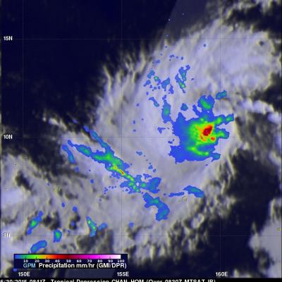
GPM Has A Good Look At Tropical Storm Raquel

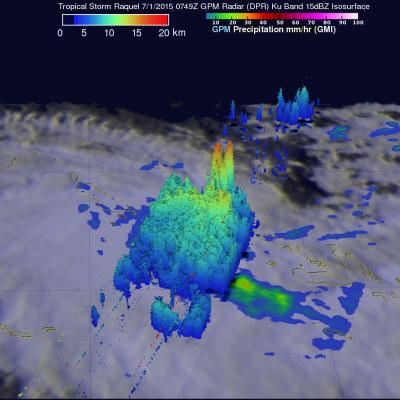
The GPM core observatory satellite recently had an excellent view of tropical storm Raquel in the South Pacific Ocean. Raquel was moving over the Solomon Islands on July 1, 2015 at 0749 UTC when viewed by GPM. Tropical cyclone activity normally ramps up in the northern hemisphere this time of the year so Raquel's development yesterday north of the Solomon Islands was a little surprising. Rainfall was measured by GPM's Dual-Frequency Precipitation Radar (DPR) and Microwave Imager (GMI) instruments. Those data showed that powerful thunderstorms within Raquel were dropping rain at a rate of over

IMERG Sees Heavy Rain Over United States

During the past week the combination of tropical storm Bill's landfall and a slowly moving frontal system extending from the Midwest to the Northeastern states dropped extreme rainfall from Texas' Gulf coast to the northeastern states. Data from NASA's Integrated Multi-satellitE Retrievals for GPM (IMERG) were used in this analysis to estimate the extreme amount of rain that fell during the past seven days. Tropical Storm Bill and it's remnants caused very heavy rainfall while moving through Texas and Oklahoma. Over a foot of rain was reported in Oklahoma resulting in at least two deaths. The

Weakening Tropical Storm Bill Seen By GPM

The GPM core observatory satellite had a good daytime look at tropical storm Bill on Wednesday June 17, 1015 at 1552 UTC ( 10:52 AM CDT). GPM saw that an area of heavy rain on Bills northern side was then moving into southern Oklahoma. The Dual-Frequency Precipitation Radar (DPR) on board the satellite measured rain dropping at a rate of over 50 mm (almost 2 inches) per hour in some intense storms. GPM radar data (Ku band) were also used to look at the 3-D structure and storm top heights within storms associated with tropical storm Bill. This image shows that in some areas the dissipating

IMERG Sees Gulf Rainfall With Tropical Storm Bill

Tropical storm Bill became the second named tropical cyclone in the Atlantic Ocean Basin when it formed in the western Gulf Of Mexico on June 16, 2015. Data from the NASA's Integrated Multi-satellitE Retrievals for GPM (IMERG) was used in this analysis to estimate rainfall from Tropical Storm Bill. Precipitation was analyzed from the time when tropical storm Bill was forming in the Gulf Of Mexico on Monday June 15, 2015 until early this morning at 0800 UTC (4 AM CDT). The storm was dropping heavy rainfall over Texas this morning but this analysis indicates that the heaviest rainfall totals, up