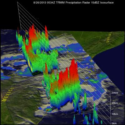
Tropical Storm Fernand Causes Deadly Mudslides

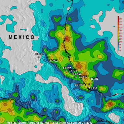
Heavy rain with tropical storm Fernand generated mudslides that caused the reported deaths of 13 people in the Mexican state of Veracruz. TRMM precipitation data are used to calibrate rainfall estimates from other satellites. The resulting TRMM- based, near-real time Multi-satellite Precipitation Analysis (TMPA) at the NASA Goddard Space Flight Center is used to estimate rainfall over a wide portion of the globe. The analysis above shows estimated TMPA rainfall totals for the period from August 20-27, 2013 when Fernand was developing and moving through the area. Total Rainfall greater than

Tropical Storm Fernand Over Eastern Mexico

Tropical storm Fernand was drenching the state of Veracruz on Mexico's Gulf Of Mexico coast when the TRMM satellite flew over on August 26, 2012 at 0534 UTC. A rainfall analysis from TRMM's Microwave Imager (TMI) and Precipitation Radar (PR) instruments is shown overlaid on an enhanced infrared image from TRMM's Visible and InfraRed Scanner (VIRS). TRMM PR found rain falling at a rate of over 118mm/hr (~4.6 inches) in rain bands north of Fernand's center of circulation. TRMM PR data revealed that Fernand had a fairly well defined center. TRMM's Precipitation Radar (PR) data were used in the

NASA Satellites Track Zebra Crossing

Submitted by JacobAdmin on
Video Embed
Botswana's Okavango Delta and the Makgadikgadi Salt Pans are two ends of a 360-mile round trip zebra migration, the second longest on Earth. In this animation, shades of red show dry areas, green represents vegetation, and the dots show GPS tracked zebras. The zebras begin at the Okavango Delta in late September. After the dry Southern hemisphere winter, November rains signal it is time to begin their two-week journey to the Salt Pans.

TRMM Sees Powerful Typhoon Utor As It Neared China

Torrential rain and powerful winds accompanied typhoon Utor when it came ashore in southern China's Guangdong province. The TRMM satellite flew above as typhoon Utor was headed toward southern China on August 13, 2013 at 2156 UTC. At the time of this TRMM pass typhoon Utor was a powerful typhoon with wind speeds reaching over 85kts (~98mph). A rainfall analysis from TRMM's Microwave Imager (TMI) and Precipitation Radar (PR) instruments is shown overlaid on an infrared image from TRMM's Visible and InfraRed Scanner (VIRS). Bands of intense rainfall are shown spiraling into the eye that was