Tropical Storm Ingrid Getting Stronger

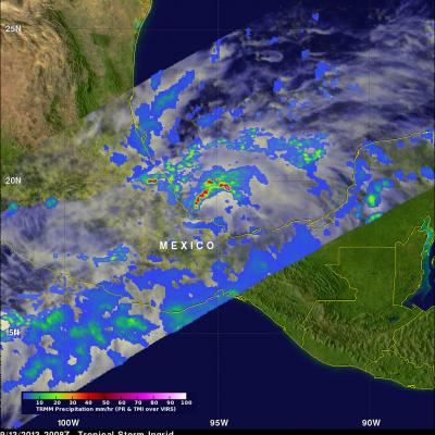
Tropical storm Ingrid in the southern Gulf Of Mexico was strengthening when the TRMM satellite flew over on September 13, 2013 at 2008 UTC (4:08 PM EDT). A band of very strong convective storms north of Ingrid's center was observed by TRMM's Precipitation Radar (PR) instrument to contain rain falling at the rate of over 143 mm/hr (~5.6 inches). Powerful thunderstorms in this area were also found by TRMM PR to reach heights above 16km (~9.9 miles). These "hot towers" are often a sign that a tropical cyclone will intensify.

Tropical Depression Gabrielle

Tropical Storm Gabrielle passed close to Bermuda on Wednesday and has now moved out of the TRMM satellite's coverage area (40N-40S). Tropical depression Gabrielle is currently moving over the open waters of the North-Atlantic toward Newfoundland and is predicted to be absorbed by a front tomorrow. A red tropical storm symbol shows the location of Gabrielle's nearly rain free center when TRMM passed above on Thursday September 12, 2013 at 2249 UTC (6:49 PM EDT).

Weaker Hurricane Humberto

Southwesterly wind shear has taken it's toll on hurricane Humberto. An eye was no longer distinct in data collected when the TRMM satellite passed over on September 12, 2013 at 1625 UTC (12:25 PM EDT). An analysis derived from TRMM Microwave Imager (TMI) and Precipitation Radar (PR) data shows that most of the precipitation with Humberto was then located in the northwestern quadrant. TRMM found that the most intense rain was falling at a rate of over 99mm/hr (~3.9 inches) at 22.4 North 28.7 West near Humberto's center. TRMM PR also found that the highest storm towers were reaching heights of

Gabrielle Seen Knocking On Bermuda's Door

Tropical storm Gabrielle was at a distance of about 50km (~31 miles) to the south-southwest of Bermuda on September 11, 2013 at 0041 (September 10, 2013 8:41 PM EDT) when the TRMM satellite flew above. A rainfall analysis from TRMM's Microwave Imager (TMI) and Precipitation Radar (PR) is shown overlaid on an enhanced infrared image from the satellite's Visible and InfraRed Scanner (VIRS). A band of light to moderate rainfall extends to Bermuda from a large area of heavy rainfall in the eastern side of Gabrielle. A red tropical storm symbol shows the surface location of tropical storm Gabrielle

TRMM Sees Gabrielle Closing In On Bermuda

The TRMM satellite flew directly above tropical storm Gabrielle on September 10, 2013 at 2124 UTC (5:24 PM EDT) as the storm approached Bermuda. TRMM's Precipitation Radar (PR) data found that rain was falling at a rate of over 127mm/hr (~5 inches) in a line of intense storms southeast of Bermuda. TRMM PR also found that the tallest thunderstorms, reaching to heights above 15.5km (~9.6 miles), were located in an area close to Gabrielle's center of circulation. Click here to see a simulated 3-D (Quicktime) flyby animation over Gabrielle approaching Bermuda using TRMM PR data. Click here to see