Hurricane Raymond Soaking Mexican Coast

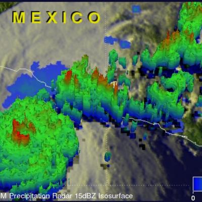
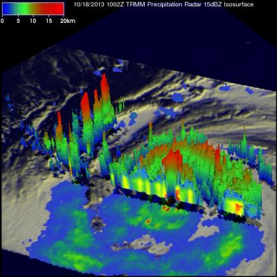
A month ago hurricane Manuel caused caused landslides and extensive flooding along Mexico's Pacific Ocean coast. Recently formed hurricane Raymond is expected to cause heavy rainfall in nearly the same area. The TRMM satellite flew directly above hurricane Raymond on October 21, 2013 at 0111 UTC (October 20 at 6:11 PM PDT). TRMM Precipitation Radar (PR) data from that orbit shows that hurricane Raymond contained towering thunderstorms on the western side of the eye wall that were reaching to heights above 15km (~9.3 miles). TRMM PR also recorded precipitation in Raymonds eye wall that was

Super Typhoon Francisco Heads Toward Japan

Super typhoon Francisco is headed toward Japan as the country is still recovering from typhoon Wipha. The TRMM satellite flew above the western Pacific and caught a good view of super typhoon Francisco on October 20, 2013 at 0947 UTC. A precipitation analysis from TRMM's Microwave Imager (TMI) and Precipitation Radar (PR) instruments found that rain was falling at the extreme rate of over 207 mm/hr (~8.1 inches) in an area of violent storms southwest of Francisco's eye. TRMM's Precipitation Radar (PR) discovered radar reflectivity values of over 53dBZ in heavy precipitation south of Francisco

TRMM Monitors Super Typhoon Francisco

The sixth super typhoon of 2013 called Francisco developed in the Western Pacific Ocean on October 16, 2013. The image on the left was made from data collected as the TRMM satellite passed over on October 18, 2013 at 1002 UTC when super typhoon Francisco was located west-northwest of Guam. A rainfall analysis that used data from TRMM's Microwave Imager (TMI) and Precipitation Radar (PR) instruments is shown on the left overlaid on an enhanced infrared image from TRMM's Visible and InfraRed Scanner (VIRS). TRMM PR found that rain was falling at a rate of over 113 mm/hr (~4.5 inches) in powerful

TD11 Upgraded To Tropical Storm Jerry

At 1500 UTC (11:00 AM EDT) the National Hurricane Center (NHC) upgraded TD11 to tropical storm Jerry. Tropical Depression ELEVEN (TD11) developed in the central Atlantic Ocean on Saturday September 28, 2013. Southwesterly wind shear reduced TD11's strengthening until this morning. TD11 was having strong bursts of convection when the TRMM satellite flew over earlier at 0929 UTC (~ 6:29 AM Local Time). The image on the left shows a rainfall analysis that uses TRMM Precipitation Radar (PR) data from that orbit. It shows that rain was falling at a rate of over 150 mm/hr from some powerful

Western India's Intense Monsoon Rain

Western India has been having intense monsoon rainfall since September 21, 2013. This has resulted in widespread flooding in the west Indian state of Gujarat and reports of at least three related deaths. India had record breaking flooding in the northern state of Uttarakhand in June 2013 with more than 6,000 people killed. Near real-time TRMM Merged HQ/Infrared Precipitation (3B42) data were used in the rainfall analysis above. Rainfall total estimates from these space satellite data for the seven day period from September 20-27, 2013 were used. The highest totals of almost 800mm (~31.5 inches