TRMM Sees Tropical Storm Lorena

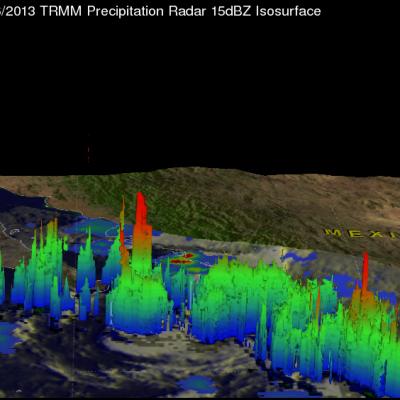
The development of tropical cyclones in the Atlantic Ocean basin has been very slow recently but tropical cyclones have formed in the Eastern Pacific Ocean at a near normal or greater than normal pace. Sixteen tropical cyclones per season usually form in the eastern Pacific and tropical storm Lorena is number fourteen. The TRMM satellite flew above this most recent Eastern Pacific tropical storm on September 6, 2013 at 0824 UTC. TRMM's Microwave Imager (TMI) and Precipitation Radar (PR) data show that Lorena did not contain large areas of precipitation. Those data do show that Lorena had one

Tropical Depression Gabrielle

The National Hurricane Center (NHC) upgraded a low pressure center south of Puerto Rico to tropical depression number seven on September 4, 2013 at 2100 UTC (5:00 PM EDT). The tropical depression was then again upgraded to tropical storm Gabrielle on September 5, 2013 at 0300 UTC (11 PM EDT). Gabrielle was subsequently downgraded to a tropical depression at 1500 UTC (11 AM EDT). The TRMM satellite's Microwave Imager (TMI) had a fairly good look at tropical storm Gabrielle very early this morning at 0614 UTC (2:14 AM EDT). TRMM's TMI found rain falling at a rate of over 56mm/hr (~2.2 inches) in

Tropical Storm Toraji Adds To Japan's Rainfall

Tropical storm Toraji quickly followed tropical storm Kong-rey and has started to again saturate Japan with flooding rainfall. The TRMM satellite flew over Toraji on September 3, 2013 at 1220 UTC. Rainfall estimates using data collected by TRMM's Microwave Imager (TMI) and Precipitation Radar (PR) instruments with this orbit are displayed in the left image. TRMM PR measured rain falling at a rate of 133 mm/hr (~5.2 inches) in an area just north of Toraji's center of circulation. The image on the right shows a 3-D view from the south of this area using TRMM PR data.

TRMM Sees Heavy Rain Over Taiwan

The TRMM satellite flew directly above western Taiwan on August 28, 2013 at 2108 UTC when tropical storm Kong-Rey was dropping enormous amounts of rain. Flooding from torrential rainfall with totals of over 500mm (~19.7 inches) have been reported in western Taiwan. This rainfall analysis from TRMM's Microwave Imager (TMI) and Precipitation Radar (PR) instruments revealed that precipitation was falling at a rate of over 205mm/hr (~8 inches) in intense bands of rain over southwestern Taiwan. Tropical storm Kong-Rey's location when TRMM flew over is shown with a red symbol. This TRMM orbit also

Tropical Storm Kong-Rey To Hit Taiwan Then Japan

Tropical storm Kong-Rey formed in the western Pacific Ocean east of the Philippines on August 26, 2013. Kong-rey passed to the northeast of the Philippines and is predicted to cross over northeastern Taiwan tomorrow. In about three days it is then predicted to be the first tropical cyclone of 2013 to hit southern Japan. The TRMM satellite had an early morning view of tropical storm Kong-Rey on August 27, 2013 at 2203 UTC (~6:03 AM local time). A precipitation analysis from TRMM's Microwave Imager (TMI) and Precipitation Radar (PR) instruments is shown on the left above overlaid on an enhanced