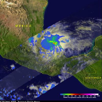
Tropical Storm COSME Becoming Stronger

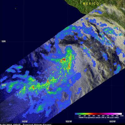
Tropical storm Cosme was illuminated by morning sunlight when the TRMM satellite flew over on June 24, 2013 at 1304 UTC (8:04 AM PDT). COSME had become much better organized since being upgraded to a tropical depression 24 hours earlier. A rainfall analysis derived from TRMM's Microwave Imager (TMI) and Precipitation (PR) data are shown overlaid on a visible/infrared image from TRMM's Visible and InfraRed Scanner (VIRS). TRMM PR found rain falling at a rate of over 113 mm/hr (~4.4 inches) just to the south of Cosme's center of circulation. TRMM's Precipitation Radar (PR) data were used to show

Tropical Storm Barry Forms & Makes Second Landfall

As predicted by the National Hurricane Center (NHC), tropical depression two strengthened in the Bay Of Campeche and became tropical storm Barry on Wednesday June 19, 2013 at 1:45 PM CDT (18:45 UTC). Barry's center of circulation made landfall today just north of Veracruz, Mexico between 1200 and 1300 UTC with 40kt(~46 mph) winds. The NHC has forecast that heavy rainfall from Barry "could cause life-threatening flash flooding and mud slides..." This image uses data captured when the TRMM satellite had a good view of tropical storm Barry on June 20, 2013 at 1510 UTC (10:10 AM CDT). A rainfall

Intensifying TD02 Moves Into The Bay Of Campeche

The TRMM satellite passed above tropical depression two on June 18, 2013 at 2336 UTC (6:43 PM CDT). A red circle shows the approximate location of TD02 just before it entered the Bay Of Campeche in the the southern Gulf Of Mexico. Data from TRMM's Microwave Imager (TMI) and Precipitation Radar (PR) instruments showed that TD02 was still only producing light to moderate rainfall. The most intense rainfall over land, at about 28.7mm/hr (~1.1 inches), was found by TRMM's TMI in a line of storms extending from northwestern Guatemala into the Gulf Of Mexico. The National Hurricane Center (NHC)

TRMM Sees Tropical Depression Two

Tropical depression two that formed on Monday June 17, 2013 was observed by the TRMM satellite on June 18, 2013 at 0034 UTC (8:34 PM EDT). TRMM's Microwave Imager (TMI) and Precipitation Radar (PR) data showed that rainfall around TD02 was mainly light to moderate with TRMM PR finding that the heaviest rainfall of slightly over 69 mm/hr (2.7 inches) was located in Nicaragua.

Tropical Storm Leepi East Of The Philippines

Today TRMM satellite also flew above tropical storm Leepi just to the east of the Philippines at 0947 UTC. Data from TRMM's Microwave Imager (TMI) and Precipitation Radar (PR) instruments found the most intense rainfall in powerful storms near Leepi's center and in rain bands spiraling into Leepi from the south. TRMM PR data were used to make this 3-D view of tropical storm Leepi's vertical structure. Some of the powerful storms near Leepi's center reached heights above 16.5km (~10.25 miles). Tropical storm Leepi is predicted by the Joint Typhoon Warning Center (JTWC) to increase slightly in