Deadly Tornadoes and Flooding Rainfall in the U.S.

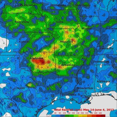
Last week's flooding and tornadoes caused the reported deaths of at least 18 people in Oklahoma. Today extensive flooding from heavy rainfall occurred in Missouri when a levee was breached. The TRMM-based, near-real time Multi-satellite Precipitation Analysis (TMPA) at the NASA Goddard Space Flight Center was used in this analysis to show rainfall over these areas. TRMM with its combination of passive microwave and active radar sensors was used to calibrate rainfall estimates from other satellites. TMPA rainfall totals are shown here for the 21-day period from May 14 to June 4, 2013. Heavy

Hurricane Barbara Comes Ashore in Southern Mexico

Hurricane Barbara recently made landfall along the southern Pacific coast of Mexico. According to the National Hurricane Center (NHC), the center of the storm came ashore around 19:50 UTC (12:50 pm PDT) Wednesday May 29th about 35 km (~20 miles) west of Tonala, Mexico as a minimal Category 1 hurricane with maximum sustained winds of 75 mph. TRMM captured the first image of Barbara several hours after it made landfall. The image was taken at 6:46 pm PDT 29 May (01:46 UTC 30 May) 2013 and shows the horizontal distribution of rain intensity within the storm. Rain rates in the center of the swath

TRMM Sees Powerful Storm Over San Antonio

Three people died this past weekend from flooding in San Antonio, Texas. The TRMM satellite flew above Texas early Saturday morning at 1118 UTC (6:18 AM CDT) when powerful thunderstorms were drenching San Antonio. Data captured with this orbit by TRMM's Microwave Imager (TMI) and Precipitation Radar (PR) were used in this rainfall analysis. TRMM's Precipitation Radar (PR) instrument found rain falling at a rate of over 66 mm/hr (~2.5 inches) in one violent thunderstorm shown near the center of this image. This 3-D image shows a TRMM Precipitation Radar (PR) slice through storms over Texas. One

Deadly Tropical Cyclone Mahasen Comes Ashore

Tropical cylone Mahasen hit southern Bangladesh causing the reported deaths of at least 12 people and the destruction of many homes. Mahasen had heavy rains accompanied with tropical storm force winds when it came ashore. The TRMM satellite had two very informative views as deadly tropical Cyclone Mahasen was moving toward and then over Bangladesh. TRMM passed above Mahasen on May 15, 2013 at 2133 UTC and saw Mahasen again on May 16, 2013 at 0406 UTC after the tropical cyclone's center passed over Bengladesh's Ganges Delta. Red tropical cyclone symbols mark Mahasen's locations with both TRMM

Tropical Cyclone Mahasen Rain Moving Into Bay Of Bengal

Tropical cyclone Mahasen is moving through the Bay of Bengal and is predicted by the Joint Typhoon Warning Center to impact southeastern Bangladesh and northwestern Myanmar (Burma) in about 4 days. This analysis shows a TRMM Multisatellite Precipitation Analysis (TMPA) of rainfall that occurred with tropical cyclone Mahasen during the past week. So far rainfall from Mahasen has fallen mainly over the open waters of the northern Indian Ocean and the Bay Of Bengal. Rainfall totals of about 500mm (~19.7 inches) are shown east of Indonesia in this analysis. Click here to see a rainfall total