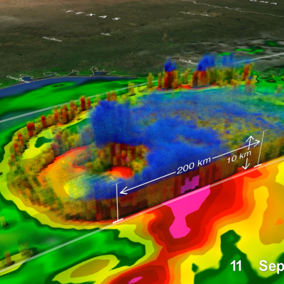
GPM Views Snow in Third Nor'easter of 2018

The GPM Core Observatory satellite flew over a powerful winter storm early on the morning of Tuesday March 13th, 2018, the third such "Nor'easter" to hit the U.S. east coast this year. GPM's Dual-frequency Precipitation Radar took 3D measurements as it flew over the storm, which show the boundary between liquid (green / yellow / red) and frozen (blue) precipitation. The storm is expected to last through most of Tuesday, disrupting road and air travel. Image and caption by Jacob Reed (Telophase / NASA GSFC

GPM Satellite Scans Powerful Tropical Cyclone Hola

The GPM core observatory satellite had a fairly good look at powerful tropical cyclone HOLA on March 8, 2018 at 0812 UTC. HOLA was located northeast of New Caledonia with maximum sustained winds of about 95 kts (~ 105 mph). The rainfall in this image was derived from data received by GPM's Microwave Imager (GMI) and Dual Frequency Precipitation Radar (DPR) instruments. GPM's GMI provided the best coverage of the tropical cyclone. GMI data indicated that storms within HOLA were dropping rain at a rate of greater than 49 mm (1.9 inches) per hour in the southeast quadrant of the tropical cyclone

GPM Observes Tropical Cyclone 12P Forming

On March 6, 2018 at 0825 UTC the GPM core observatory satellite flew above a forming tropical cyclone in the southern Pacific Ocean just east of Vanuatu. GPM's Dual Frequency Precipitation Radar (DPR) scanned storms in the center of forming tropical cyclone 12P's circulation. This view by GPM's DPR revealed that convective storms were dropping extremely heavy rainfall on the eastern edge of the forming tropical cyclone's low level center. DPR indicated that rain was falling at a rate of over 241 mm (9.5 inches) per hour in this area. The use of GPM satellite's radar data enabled this 3-D view

GPM Examines Tropical Cyclone Dumazile's Flooding Rainfall

Tropical cyclone DUMAZILE formed east of Madagascar on March 3, 2018. Since then the tropical cyclone has been causing flooding as the tropical cyclone moves parallel to Madagascar's eastern coast. The clockwise rotation of the tropical cyclone has been transporting bands of rain onto Madagascar. Over 210 mm (8.3 inches) of precipitation was reported along the northeastern coast of Madagascar. The GPM core observatory satellite passed over eastern Madagascar on March 3, 2018 at 1710Z. Tropical cyclone DUMAZILE was located in the Indian Ocean east of northeastern Madagascar. The tropical

Replacement GPM Ka/Ku L1B products (2018-03-02->2018-03-03) orbits 22779, 22780, 22786

PPS received replacement GPM Ka/Ku L1B (22779,22780,22786) products from JAXA and will reprocess the affected data including Level 2 and 3 data. If you have already obtained products with orbit# 22779,22780,22786 from our archive or through a standing order, etc., please discard and use the replacement products. PPS has replaced the following GPM Ka/Ku L1B data: GPMCOR_KUR_1803022048_2221_022779_1BS_DUB_05A.h5 GPMCOR_KAR_1803022048_2221_022779_1BS_DAB_05A.h5 GPMCOR_KUR_1803022221_2353_022780_1BS_DUB_05A.h5 GPMCOR_KAR_1803022221_2353_022780_1BS_DAB_05A.h5 GPMCOR_KUR_1803030736_0908_022786_1BS