

GPM Satellite Data Outages During 23-24 March 2022

A mis-set error counter on the Core Observatory provoked a safe hold at 13:31:29 UTC on 23 March 2022, shutting down DPR and GMI observations. DPR and GMI were restored at 10:54 and 14:54 UTC, respectively on 24 March 2022. No data were recoverable from the outage period, although IMERG Early and Late continued to be produced (without GMI input, of course). The same will be true for the Final Run when it is produced. An outage at FNMOC prevented transmission of DMSP (SSMIS) from 15:51 UTC 23 March 23 to 00:47 UTC 24 March 2022. Gaps in the data are: F16: 14:34:07-19:29:39, F17: 14:56:24-19:46
Ensemble-Based Assimilation of Satellite All-Sky Microwave Radiances Improves Intensity and Rainfall Predictions for Hurricane Harvey (2017)

Submitted by LisaN on
Publication Year
Authors
Zhang, Y., S. B. Sieron, Y. Lu, X. Chen, R. G. Nystrom, M. Minamide, M.-Y. Chan, C. M. hartman, Z. Yao, J. H. Ruppert Jr., A. Okazaki, S. J. Greybush, E. E. Clothiaux, and F. Zhang
Journal
Geophys. Res. Letts.
Volume
48(24)
Page Numbers
e2021GL096410
DOI
10.1029/2021GL096410
Mission Affiliation
Major Category
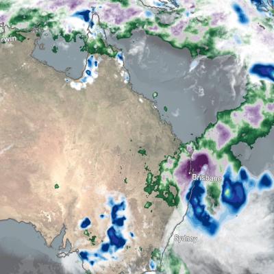
IMERG Rainfall Totals from Australian :"Rain Bomb" in March 2022
The below animation shows surface rainfall estimates from NASA’s IMERG multi-satellite precipitation product for the week starting on Feb. 22, 2022 at 0000 UTC and ending on Feb. 28, 2022 at 2330 UTC. Areas shaded in blue and yellow show three-hour average snapshots of IMERG rain rates every half-hour overlaid on cloudiness (shown in white/gray) based on geosynchronous satellite infrared observations. Below the rain rates and cloudiness data, IMERG rainfall accumulations are shown in green and purple. Tropical Cyclone Anika’s track is shown with a gray line based on data from the U.S. Navy-Air
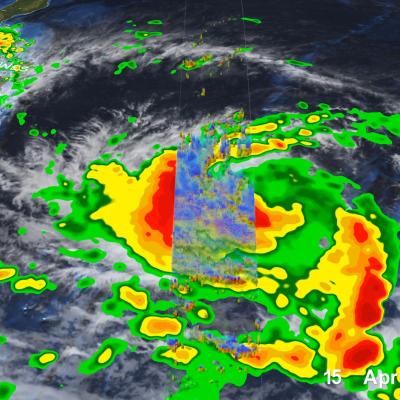
GPM Overpass of Typhoon Surigae
Although it was only the 2nd named storm of the 2021 Pacific typhoon season, Typhoon Surigae became not only the first super typhoon of the season, but also the strongest tropical cyclone of 2021 worldwide. The majority of storms in the Northwest Pacific region form between June and Nov., but the season runs yearlong, as storms can form in any month in this region, which stretches from 100 degrees East to 180 degrees East, north of the equator. Surigae originated from an area of low pressure about 700 miles south of Guam. Persistent thunderstorm activity resulted in the formation of a tropical