Weakening Tropical Cyclone Cebile Examined By GPM

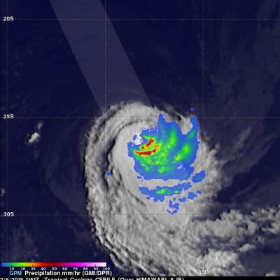
The GPM core observatory satellite passed above weakening tropical cyclone CEBILE on February 6, 2018 at 1151 UTC. CEBILE's maximum sustained winds had decreased to about 40 kts (46 mph). The satellite showed that most of the convective rainfall in the sheared tropical cyclone was southeast of CEBILE's center of circulation. Dual Frequency Precipitation Radar (DPR) data received by GPM with this pass showed that the northeastern side of the eye wall was eroding while continuous heavy precipitation was found by GPM in the southeastern quadrant of the storm. The area scanned by GPM's DPR is

TRMM-era Constellation Level 2-Level 3 V05 Product release

With the evaluation and approval, PPS will start to process the TRMM era AMSRE, AMSUB and SSMI level 2 and level 3 GPROF products on Wednesday, February 7, 2018. Similar to the early released TRMM era MHS, SSMIS, AMSR2 and ATMS level 2 and level 3 products, all level 2 and level 3 GPROF products will be produced as GPM version V05, all products are in HDF5 format, all product names will use the GPM naming convention and the produced data will appear both in STORM: https://storm.pps.eosdis.nasa.gov/storm/ and on "arthurhou": ftp://arthurhou.pps.eosdis.nasa.gov/ after these are produced. All

GPM Probes Powerful Tropical Cyclone Cebile

Tropical Cyclone CEBILE formed four days ago in the southwest Indian Ocean southeast of Diego Garcia. Today CEBILE became the most powerful tropical cyclone to form in the southern hemisphere this year. Maximum sustained wind speeds within CEBILE were estimated at 120kts (138 mph) early today making CEBILE the equivalent of a category 4 hurricane on the Saffir-Simpson hurricane wind scale. The GPM core observatory satellite passed directly above the well defined circular eye of tropical cyclone CEBILE on January 31, 2018 at 0034 UTC. Rainfall intensity and coverage within CEBILE were revealed

GPM Views Sheared Tropical Cyclone Fehi

The GPM core observatory satellite flew tropical cyclone FEHI on January 30, 2018 at 0831 UTC. GPM revealed that precipitation was only located around the southern side of FEHI's circulation. Strong vertical wind shear had caused the surface center of circulation (shown with a red symbol) to be displaced well to the north of the heaviest rainfall. The satellite found that some convective storms on the southern side of the tropical cyclone were still producing very heavy precipitation. GPM's Microwave Imager (GMI) and Dual Frequency Precipitation Radar (DPR) instruments revealed rainfall in a

IMERG V05B Retrospective Processing and SAPHIR precipitation

Effective 27 January 2018 all the IMERG Early products have a retrospective V05B processing for the entire GPM mission starting in March 2014. All V04 products have been saved in a V04 directory. V03 products are no longer available. Effective 27 January 2018 IMERG Late products have a retrospective V05B processing from the beginning of the mission in March 2014 to January 2017. We continue to process Late products and they should be completed in another week. We are also working on retrospective processing to V05B of the GIS friendly TIFF IMERG based products. These should all be at V05B in