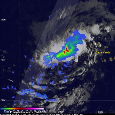
Intensifying Hurricane Irma Checked By GPM Satellite

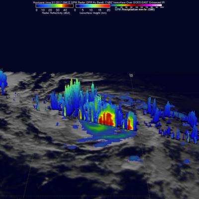
After forming in the eastern Atlantic Ocean on Wednesday tropical storm Irma strengthened and became a powerful category three hurricane on Thursday August 31, 2017. Hurricane Irma was moving west-northwestward with winds of about 115 mph (100 kts) when the GPM core Observatory satellite saw it on September 1, 2017 at 1:47 AM AST (0547 UTC). Data collected by GPM's Microwave Imager (GMI) and Dual-Frequency Precipitation Radar (DPR) instruments showed the locations and intensity of heavy precipitation within the hurricane. GPM's Radar (DPR Ku band) found that a powerful convective storm in a

GPM Satellite Sees Tropical Storm Irma Forming Near Cape Verde Islands

The National Hurricane Center (NHC) upgraded a low pressure area in the far eastern Atlantic Ocean to tropical storm Irma on August 30, 2017 at 11:00 AM AST (1500 UTC). Tropical cyclones that form in that part of the Atlantic Ocean are often the largest and most powerful hurricanes of the season. Hurricanes Ivan (2004), Isabel (2003), Hugo (1989) and Allen (1980) are examples of past powerful hurricanes that formed near the Cape Verde islands. The GPM core observatory satellite flew above forming tropical storm Irma on August 30, 2017 at 1:56 AM EDT (0556 UTC). This new tropical cyclone was

NASA's IMERG Shows Rainfall Accumulation Along Harvey's Track

Total rainfall estimates from NASA's Integrated Multi-satelliE Retrievals for GPM (IMERG) data are shown here for the period from August 23-29, 2017. During this period hurricane Harvey dropped heavy rainfall as it moved through the Gulf Of Mexico and stalled over Texas. It has been reported that Harvey dropped over 40 inches (1016 mm) of rain over southeastern Texas during this period. Hurricane Harvey's locations and track are shown here overlaid in white IMERG Data are produced using data from the satellites in the GPM Constellation, and is calibrated with measurements from the GPM Core

GPM's Radar Measures Intense Rain In Hurricane Harvey

Hurricane Harvey's has continued to intensify today as it moves toward the Texas coast. Bands of rain from the hurricane were affecting the Gulf coast from Louisiana to southeastern Texas. The Global Precipitation Measurement (GPM) mission core observatory satellite had another look at hurricane Harvey on August 25, at 7:50 AM CDT (1150 UTC) as it was menacing the Texas gulf coast. GPM's Dual-Frequency Precipitation Radar (DPR) instrument scanned precipitation within powerful storms wrapping around the eastern side of the hurricane. DPR found that intense storms in that area were dropping rain

GPM Observes Intensifying Hurricane Harvey's Rainfall

UPDATE: View the latest GPM overpass from 8/25/17 1141 UTC using the STORM Event Viewer: https://storm.pps.eosdis.nasa.gov/storm/cesium/EventViewer.html?positio… Hurricane Harvey has continued to intensify after regenerating in the southwestern Gulf of Mexico on Wednesday. Harvey's intensification has been aided by moving through an environment that includes low vertical wind shear and the warm waters in the Gulf Of Mexico. The Global Precipitation Mission (GPM) core observatory satellite