Intensifying Tropical Cyclone Dineo Seen By GPM

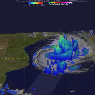
Tropical cyclone Dineo was intensifying in the middle of the Mozambique Channel when the GPM core observatory satellite flew over on February 14, 2017 at 0926 UTC. Dineo had winds of about 55 kts (~ 63.3 mph) at the time of this GPM pass. Very heavy precipitation was found in feeder bands on Dineo's northeastern side. The most intense rainfall was measured by GPM's Dual-Frequency Precipitation Radar (DPR) falling at a rate of over 132 mm (5.2 inches) per hour in the intense storms in the northeastern quadrant of the tropical cyclone. GPM's radar (DPR Ku Band) sliced through the center of
Document Description

Owing to the Global Precipitation Measurement (GPM) core satellite’s unique asynchronous orbit, its orbital ground tracks intersect the orbital tracks of many other sun-synchronous satellites. Of particular interest are the intersections (coincidences) between the GPM core satellite and the 94-GHz (W-band) CloudSat profiling radar (CPR), within small enough time differences, such that the combination of the resulting “pseudo three-frequency” radar profiles (W-band from CPR, and Ku/Ka-band from GPM), and the 13-channel (10-183 GHz) GMI radiometer are useful for many scientific purposes.

Document Description

This document describes the algorithms for the Geolocation Toolkit (GeoTK) for the Global Precipitation Measurement (GPM) Mission. The core part of the algorithm uses input orbit ephemeris, spacecraft attitude, and instrument pointing data to compute each pixel latitude and longitude viewed, along with ancillary data such as zenith/incidence and Sun angle data. These calculations are implemented in the GeoTK software subroutines, which will be used for Level 1B (L1B) algorithms for GPM.

Date Last Updated
October 1st, 2016
Document Description

This document describes the GMI Level 1B algorithm developed by PPS. It consists of physical bases and mathematical equations for GMI calibration, as well as after-launch activities. The document also presents high-level software design. Parts of this document are from the Remote Sensing Systems (RSS) GMI Calibration ATBD and the BATC Calibration Data Book as contributed by the BATC GMI manufactory contract. The GMI L1B geolocation algorithm is described in a separate Geolocation Toolkit ATBD.

File Downloads