Tropical Storm Carlos Forms
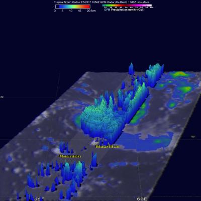
Tropical storm Carlos formed in the Southwest Indian Ocean north of the French Islands of Reunion and Mauritius on February 4, 2017 (UTC). This ended an unusual drought of tropical cyclone formation in that part of the Indian Ocean that began in July 2016. NASA's GPM core observatory satellite flew above tropical storm Carlos on February 5, 2017 at 1056 UTC when Carlos had maximum sustained winds of about 45 kts (51.8 mph). GPM collected data that showed the intensity and structure of precipitation within Carlos. GPM's Dual-Frequency Precipitation Radar (DPR) measured rain falling at a rate of