GPM Examines Violent Thunderstorms in U.S.

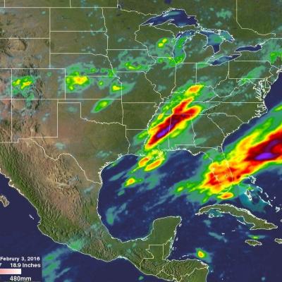
Severe weather moved through the southern U.S. on February 2 and 3, and NASA's Global Precipitation Measurement or GPM core satellite examined the violent thunderstorms. On February 3, 2016 at 1851 UTC (1:51 p.m. EST) the GPM core observatory satellite flew over a line of storms extending from the Gulf coast of Florida through New York state. Tornadoes were spotted in Georgia and South Carolina within this area of violent weather. GPM's Microwave Imager (GMI) and Dual-frequency Precipitation Radar (DPR) instruments measured the precipitation within the area. As the satellite passed above, GPM

Extreme Precipitation Measured From Space

For over a week the weather over the continental United State's has been punctuated by extreme events. Automobiles were thrown around on January 27, 2016 by tornadoes that hit southern Florida. On January 31 a winter storm with heavy rain, strong winds and isolated thunderstorms hit southern California killing at least one person. There were numerous reports of hail with these storms ranging from pea sized to up to an inch in diameter. Powerful winds with these storms also brought down trees and power lines. A blizzard that followed the Democratic and Republican caucuses in Iowa dropped over

OLYMPEX Successfully Grabs the Rains

Submitted by JacobAdmin on
Video Embed

NASA is finishing its campaign to study extreme rain, snow and winds of the Olympic National Forest. Scientists Walt Petersen of NASA Marshall and Robert Houze of the University of Washington narrate this inside look at the Olympic Mountain Experiment (OLYMPEX) field campaign. During the campaign, NASA and its partners gathered precipitation data through both ground and airborne instruments around the Olympic Peninsula in Washington State. They measured the abundance and variety of precipitation including light rain, heavy thunderstorms, and snowfall in the coastal forest.

Intensifying Tropical Low Threatens Western Australia

So far this year, no tropical cyclones have formed near Australia. A tropical low is now getting better organized in the Indian Ocean off Australia's northwestern coast. The GPM core observatory flew over this area of disturbed weather on January 27, 2016 at 0946 UTC. GPM's Dual-frequency Precipitation Radar (DPR) instrument measured rain falling at a rate of 96.7 mm (3.8 inches) per hour in towering convective storms within spiraling bands around the tropical low. GPM's Radar (DPR Ku band) made 3-D measurements of convective storm top heights. Some storm tops were found to reach altitudes of

GPM Flies Over Dissipating Tropical Cyclone Corentin

Tropical cyclone Corentin was the first named tropical cyclone of 2016 in the South Indian Ocean. Corentin caused little danger because it's genesis, maturation and dissipation have all occurred over the South Indian Ocean about equidistant from the distant shores of Madagascar and Australia. The GPM core observatory satellite flew over Tropical Cyclone Corentin on January 25, 2016 at 1306 UTC. High vertical wind shear was starting to take it's toll on the increasingly disorganized tropical cyclone. Rainfall collected by GPM Microwave Imager (GMI) and Dual-frequency Precipitation Radar (DPR)