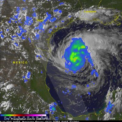
What is the difference between a tornado and a hurricane?

Both tornadoes and hurricanes are characterized by extremely strong horizontal winds that swirl around their center and by a ring of strong upward motion surrounding downward motion in their center. In both tornadoes and hurricanes, the tangential wind speed far exceeds the speed of radial inflow or of vertical motion.

Hurricanes always and tornadoes usually rotate counterclockwise in the northern hemisphere and clockwise in the southern hemisphere. The Earth's rotation determines this direction for the storms' rotation in each hemisphere. Local winds are sometimes able to cause a tornado to form that spins in the opposite direction from the typical direction for that hemisphere.

The most obvious difference between a tornado and hurricane is that a hurricane's horizontal scale is about a thousand times larger than a tornado. In addition, hurricanes and tornadoes form under different circumstances and have different impacts on the atmosphere.

Tornadoes are small-scale circulations, that are rarely more than a few hundred feet across when they touch the ground. Most tornadoes grow out of severe thunderstorms that develop in the high wind-shear environment of the United States Central Plains during spring and early summer.  Many tornadoes form when the large-scale wind flow leads to a violent clash between moist, warm air traveling north from the Gulf of Mexico and cold, dry, continental air coming from the United States Northwest. Tornadoes can also form in many other locations and from other forcing factors. For example, a hurricane making landfall may trigger many tornadoes to form.

Tornado wind speeds may reach 100 to 300 mph and cause havoc on the ground, but tornadoes typically last only a few minutes and rarely travel more than 10 or 20 miles along the ground. Tornadoes have little impact on storms that spawn them or collectively on the global circulation of the atmosphere.

Hurricanes, on the other hand, are large-scale circulations that are 60 to over 1,000 miles across. Hurricanes form near the Equator, generally between 5 and 20 degrees latitude, but never right on the Equator. Hurricanes always form over the warm waters of the tropical oceans and generally where the sea-surface temperature exceeds 26.5°C (76°F).

A hurricane may travel thousands of miles and persist over several days or weeks. During its lifetime, a hurricane will transport a significant amount of heat up from the ocean surface and into the upper troposphere or even lower stratosphere. Even though hurricanes form only sporadically, they do affect the global atmosphere's circulation in measurable ways, although this is still an active area of research.

Extreme Weather News

Jump to a Year

2022 | 2021 | 2020 | 2019 | 2018

2017 | 2016 | 2015 | 2014 | 2013

2012 | 2011 | 2010 | 2009 | 2008

2007 | 2006 | 2005 | 2004 | 2003

2002

Tropical Storm 14W Examined By The GPM Satellite

Tropical storm 14W formed in a remote area of the western Pacific Ocean southeast of Wake Island on August 11, 2017. The GPM core observatory satellite flew above the center of the newly formed tropical storm on August 11, 2017 at 0902 UTC. The "core" satellite carries advanced radar and radiometer systems that measure precipitation from space and serves as a standard that is used to unify precipitation measurements from a constellation of research and operational satellites. Tropical storm 14W was revealed by GPM to be small but well organized with very intense convective storms near the

GPM Sees Franklin Becoming A Hurricane

As expected, tropical storm Franklin intensified and was upgraded to hurricane Franklin in the afternoon of August 9, 2017. Franklin made landfall on the coast of eastern Mexico early this morning as a category 1 hurricane with winds of over 86 mph (75 kts). Heavy rainfall, flash floods and mudslides are expected as Franklin moves inland and weakens. The remnants of Franklin may survive the transit over Mexico's rough terrain and revive after moving into the eastern Pacific Ocean. The GPM core observatory satellite saw tropical storm Franklin with winds of about 69 mph (60 kts) as it was

GPM Sees Intensifying Tropical Storm Franklin

The GPM core observatory satellite had an informative pass over Tropical storm Franklin on August 9, 2017 at 0302 UTC. The intensifying tropical storm had moved from Mexico's Yucatan Peninsula into the southwestern Gulf Of Mexico's Bay of Campeche. GPM's Microwave Imager (GMI) and Dual-Frequency Precipitation Radar (DPR) data showed that Franklin contained a few heavy bands of convective rainfall. GPM's DPR found rain falling at a rate of over rain 2.4 inches (62 mm) per hour in bands of intense storms moving around the southwestern side of the storm. This 3-D view of tropical storm Franklin

Hilary And Irwin Interaction Shown

Tropical cyclone development in the eastern Pacific Ocean has been occurring at a slightly above normal pace this year. Hurricanes Hilary and Irwin were the two most recently named tropical cyclones to form in this area. These two were a little unusual because they traveled so close to each other that an interaction occurred that radically changed the direction and speed of tropical storm Irwin's movement. The Fujiwara effect happens when cyclones move close of one another. Their centers will sometimes begin orbiting cyclonically (in the northern hemisphere) about a point between the two

GPM Catches a Look at a Rare Tornadic Storm Near the Chesapeake Bay

Tornadic storms in Maryland are rare to begin with, let alone in the middle of the night. However, about an hour after midnight in the early morning hours of Monday April 24th at around 1:00 am local time, a severe thunderstorm, which was located at the southern end of a mass of storms and which had just dumped heavy rains over the Washington, DC area, began to cross the Chesapeake Bay near Annapolis, Maryland heading eastward. It is quite common for storms to weaken as they cross the cooler waters of the Bay, but water temperatures are now rather warm, over 80F, which allowed the storm to