Images and caption by Hal Pierce (SSAI/NASA GSFC)

GPM Sees Hurricane Max Approaching Mexico's Coast

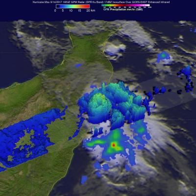
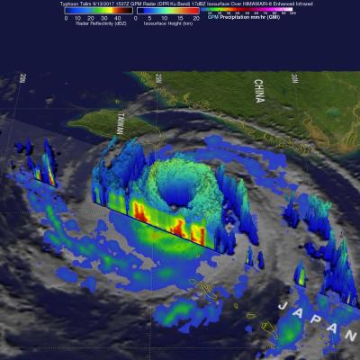
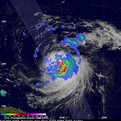
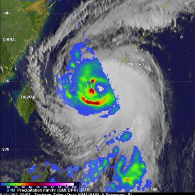
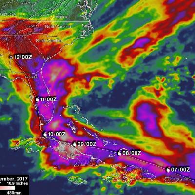
Hurricane Max made landfall on Mexico's southern Pacific coast yesterday afternoon. Max was a small hurricane with maximum sustained winds of about 86 mph (75 kts). By this morning wind speeds in the dissipating storm had decreased to about 29 mph (25 kts). Max's dissipating remnants are still expected to produce heavy rain as they continue moving eastward today. The GPM core observatory satellite passed above Hurricane Max on September 14, 2017 at 11:35 AM CDT (1653 UTC) as Max was close to making landfall east of Acapulco, Mexico. Although Max was a small hurricane the GPM satellite's radar

GPM Examines Typhoon Talim's Large Eye

The GPM cored observatory had another outstanding view of typhoon Talim in the western Pacific Ocean on September 13, 2017 at 1537 utc. A large eye was Talim's most distinctive feature. GPM's Microwave Imager (GMI) and Dual-Frequency Precipitation Radar (DPR) showed the location of intense rainfall within Talim's distinct eye wall. DPR revealed that rain was falling at a rate of over 232 mm (9.13 inches) per hour in convective storms in the western side of the typhoon's eye wall. GPM also showed that rainfall was far weaker to the the east of Talim's center. This dramatic 3-D view of Talim's

GPM Finds Sheared Hurricane Jose Has Very Tall Storms

On Wednesday September 13, 2017 at 10:35 AM AST (1435 UTC) the GPM core observatory satellite traveled above persistent hurricane Jose as it was meandering in the Atlantic Ocean. GPM found that even though Jose was affected by strong northwesterly shear it contained very powerful convective storms. GPM's Dual-Frequency Precipitation Radar (DPR) found extremely intense downpours within these storms where rain was measured by DPR falling at a rate of over 8.9 inches (227 mm) per hour. GPM's radar (DPR Ku Band) was used to show a 3-D cross-section of the precipitation within hurricane Jose. This

GPM Sees Typhoon Talim Threatening Islands Of Japan

The Joint Typhoon Warning Center (JTWC) predicts that typhoon Kalim in the western Pacific Ocean will intensify and threaten the islands of southern Japan in the the new three days. Environmental conditions such as low vertical wind shear and warm sea surface temperatures are favorable for Talim's intensification. Talim's winds are expected to increase to a peak of 115 kts as it re-curves toward the the Japanese island of Kyushu. The GPM core observatory satellite scanned the western side of typhoon Talim on September 13, 2017 at 0216 UTC. GPM's Microwave Imager (GMI) instrument collected data

Irma’s Heavy Rainfall Measured With GPM IMERG

Hurricane Irma dropped extremely heavy rain at times during it’s trek from near the Cape Verdi Islands through the northern Leeward islands, Cuba and the southeastern United States. Over 16 inches (406 mm) of rain was reported in Guantanamo, in the easternmost province of Cuba, as the category five hurricane battered the country. Almost 16 inches (406 mm) of rain was also reported at Fort Pierce on the eastern side of Florida. Charleston, South Carolina reported 6 inches (152.4 mm) of rain in 24 hour. This heavy rainfall plus storm surge flooding caused the worst flooding in Charleston since

Intensifying Tropical Storm Jose

On September 5, 2017 tropical Storm Jose became the tenth named storm of the Atlantic hurricane season. The GPM core observatory satellite passed above the intensifying tropical cyclone on September 6, 2017 at 00:45 AM AST (0435 UTC). Data collected by GPM's Microwave Imager (GMI) at that time showed that weak bands of rain were starting to develop around Jose's center of circulation. GPM's Dual-Frequency Precipitation Radar (DPR) data swath revealed the location of heavy rain in a feeder band on Jose's western side. DPR found that rain in this area was falling at a rate of over 5.3 inches

GPM Sees Potential Tropical Depression Developing In The Gulf Of Mexico

The GPM Core Observatory satellite had an excellent view of a potential tropical depression developing in the Gulf Of Mexico on September 5, 2017 at 3:34 AM CDT (0834 UTC). GPM found that powerful convective storms were dropping heavy rainfall in the Gulf of Mexico east Mexico's coast. GPM's Dual-Frequency Precipitation Radar (DPR) instrument measured rain falling at a rate of over 9.2 inches (233 mm) per hour in an intense band of storms. GPM's Radar (DPR Ku Band) data was used to examine the 3-D structure of precipitation in this area of strong convective storms. GPM's DPR showed that storm

Intensifying Hurricane Irma Checked By GPM Satellite

After forming in the eastern Atlantic Ocean on Wednesday tropical storm Irma strengthened and became a powerful category three hurricane on Thursday August 31, 2017. Hurricane Irma was moving west-northwestward with winds of about 115 mph (100 kts) when the GPM core Observatory satellite saw it on September 1, 2017 at 1:47 AM AST (0547 UTC). Data collected by GPM's Microwave Imager (GMI) and Dual-Frequency Precipitation Radar (DPR) instruments showed the locations and intensity of heavy precipitation within the hurricane. GPM's Radar (DPR Ku band) found that a powerful convective storm in a

GPM Satellite Sees Tropical Storm Irma Forming Near Cape Verde Islands

The National Hurricane Center (NHC) upgraded a low pressure area in the far eastern Atlantic Ocean to tropical storm Irma on August 30, 2017 at 11:00 AM AST (1500 UTC). Tropical cyclones that form in that part of the Atlantic Ocean are often the largest and most powerful hurricanes of the season. Hurricanes Ivan (2004), Isabel (2003), Hugo (1989) and Allen (1980) are examples of past powerful hurricanes that formed near the Cape Verde islands. The GPM core observatory satellite flew above forming tropical storm Irma on August 30, 2017 at 1:56 AM EDT (0556 UTC). This new tropical cyclone was

NASA's IMERG Shows Rainfall Accumulation Along Harvey's Track

Total rainfall estimates from NASA's Integrated Multi-satelliE Retrievals for GPM (IMERG) data are shown here for the period from August 23-29, 2017. During this period hurricane Harvey dropped heavy rainfall as it moved through the Gulf Of Mexico and stalled over Texas. It has been reported that Harvey dropped over 40 inches (1016 mm) of rain over southeastern Texas during this period. Hurricane Harvey's locations and track are shown here overlaid in white IMERG Data are produced using data from the satellites in the GPM Constellation, and is calibrated with measurements from the GPM Core