Images and caption by Hal Pierce (SSAI/NASA GSFC)

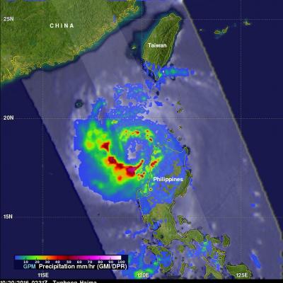
Typhoon Haima Hits China After Devastating The Northern Philippines

After Haima's caused extensive destruction and at least 13 deaths in the northern Philippines the typhoon traveled across the South China Sea to batter Hong Kong and mainland China. Heavy rain and gusty winds accompanied Haima as the typhoon passed to the east of Hong Kong. Operations at Hong Kong's international airport were nearly stopped by the typhoon. At least one person was reported killed in Hong Kong. Haima made landfall in China 110 km (68 miles) east of Hong Kong at about 0400 UTC (noon CST). Haima's winds were decreasing and the typhoon was the equivalent of a category one hurricane

GPM Measures Extreme Rainfall With Typhoons Sarika and Haima

Two powerful typhoons have hit the Philippines in less than a week. The first was Typhoon Sarika (known as Karen in the Philippines) that formed east of the Philippines on October 12, 2016. Sarika intensified and had peak sustained winds of 115 kts (132 mph). This wind speed made it the equivalent of a category four on the Saffir-Simpson hurricane wind scale. Sarika made landfall in the Philippines on Sunday in the northern province of Aurora on the island of Luzon. Three people were killed as Sarika pounded the Philippines with heavy winds and flooding rainfall. After hitting the Philippines

Hurricane Nicole Moving Over Cold North Atlantic

Hurricane Nicole has now been active for almost two weeks. Nicole was still a hurricane with winds of about 70 kts (81 mph) when the GPM core observatory satellite flew over on October 17, 2016 at 0436 UTC (2:36 am EDT). The GPM satellite had a good look at the rainfall in Nicole's large ragged eye. GPM's Dual-Frequency Precipitation Radar (DPR) swath sliced through the center of Nicole's eye and found some very heavy rainfall. A few strong storms in the southern side of the eye were dropping rain at a rate of over 113 mm (4.4 inches) per hour. GPM's radar (DPR KU band) data collected with

Deadly Hurricane Matthew's Total Rainfall

Hurricane Matthew devastated western Haiti and killed over 1,000 people. Matthew also took the lives of at least 37 deaths in the United States with 18 deaths occurring in the state of North Carolina. Flooding is still widespread in North Carolina. Some rivers in North Carolina such as the Tar and the Neuse are still rising. This rainfall analysis was accomplished using data from NASA's Integrated Multi-satelliE Retrievals for GPM (IMERG). IMERG is a unified U.S. algorithm that provides a multi-satellite precipitation product. IMERG is run twice in near-real time with the “Early” multi

GPM Finds Heavy Rain In Tropical Storm Ulika

The GPM core observatory satellite had a good early morning look at newly formed tropical storm Ulika on September 27, 2016 at 5:26 AM HST (1526 UTC). Ulika was located in the central Pacific Ocean less than 975 nautical miles east-southeast of Hilo, Hawaii. GPM found that Ulika contained some very powerful convective storms and a well defined center of circulation. GPM's Dual-Frequency Precipitation Radar (DPR) discovered that some strong convective storms inside the tropical storm were dropping precipitation at a rate of over 187 mm (7.4 inches) per hour. A GPM radar slice through the center

GPM Views Still Energetic Tropical Depression Karl

Tropical Depression Karl's strength has fluctuated. Karl formed on September 14th in the eastern Atlantic, strengthened to tropical storm intensity on September 16th and was downgraded to a tropical depression yesterday. The GPM core observatory satellite had an outstanding view of Karl when it passed above today at 1201 UTC (8:01 AM EDT). Data collected by GPM's Microwave Imager (GMI) and Dual-Frequency Precipitation Radar (DPR) instruments uncovered heavy rainfall inside storms within the tropical depression. DPR found that powerful convective storms near Karl's center of circulation were

Remnants Of Post Tropical Storm Julia Checked By GPM

The National Hurricane Center (NHC) issued the last advisory on post tropical storm Julia on September 19, 2016 but the remnants have persisted off the Southeast coast. The remnants of the low are interacting with a slow moving frontal system and are now dropping rain over eastern North Carolina and Virginia. The GPM core observatory satellite flew over this area on Tuesday September 20, 2016 at 7:31 PM EDT (2331 UTC). The satellite's Microwave Imager (GMI) and Dual-Frequency Precipitation Radar (DPR) instruments showed the location and intensity of heavy rainfall within this area of low

GPM Sees Typhoon Malakas Starting To Batter Japan

September 19, 2016 0046 UTC September 19, 2016 1031 UTC After causing high winds and heavy rainfall over northern Taiwan, typhoon Malakas is now starting to batter the islands of southern Japan. The GPM core observatory satellite passed above typhoon Malakas twice on September 19, 2016. The first time was at 0046 UTC when the typhoon was starting to cause light to moderate rainfall over the island of Kyushu. At 1031 UTC GPM showed that moderate to heavy rainfall was moving over Kyushu and the typhoon's appearance had changed significantly. The change in appearance was credited to increased

3D Precipitation Structure Within Hurricane Orlene Examined By GPM Satellite

Orlene, the 9th hurricane of the 2016 eastern Pacific season has weakened to a tropical storm. The GPM core observatory satellite flew over on September 15, 2016 at 1801 UTC when Orlene was still a hurricane with winds reaching about 70 kts (81 mph). Hurricane Orlene's rainfall was examined in 3-D using data collected by the GPM satellite's Dual-Frequency Precipitation Radar (DPR). This digital "CAT scan" like view inside hurricane Orlene shows the locations of the most intense rainfall. An area of heavy downpours was uncovered near the center of Orlene's center of circulation. Radar

GPM Observes Weakening Tropical Storm Julia

Tropical storm Julia was recently downgraded to a tropical depression. The GPM core observatory satellite had an excellent view of tropical storm Julia on September 14, 2016 at 9:36 PM EDT ( September 15, 2016 0136 UTC). Julia was barely a tropical storm at that time with maximum sustained winds of about 40 mph ( 35 kts). Over the past few days Julia has dropped heavy rain along the Atlantic coastline from northeastern Florida to North Carolina. Some areas have received over 8 inches (203 inches) during the past few days. The GPM satellite measured Julia's rainfall and found that intense