Images and caption by Hal Pierce (SSAI/NASA GSFC)

GPM Takes Parting Look At Hermine

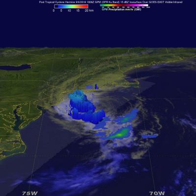
Post Tropical Cyclone Hermine was still rotating in the Atlantic Ocean east of New Jersey when the the GPM core observatory satellite flew above on September 6, 2016 at 2:05 PM EDT ( 1806 UTC). Hermine's power was greatly dissipated from the hurricane that hit Florida on September 2, 2016. Hermine still had maximum sustained winds of about 58 mph (50 kts). Hermine was also still producing some light to moderate showers. Precipitation data shown here were derived from GPM's Microwave Imager (GMI) and Dual-Frequency Precipitation Radar (DPR) instruments. Those data showed that rain was falling

GPM Sees Increasingly Organized Tropical Storm Hermine

Tropical Depression Nine was upgraded to Tropical Storm Hermine on Wednesday August 31, 2016 at 2 PM EDT (1800 UTC). The GPM core observatory satellite passed directly above newly designated tropical storm Hermine on August 31, 2016 at 4:06 PM EDT (20:06 UTC). Rainfall data derived from GPM's Microwave (GMI) and Dual-Frequency Precipitation Radar (DPR) instruments showed that precipitation intensity had increased and moved into western Florida. Rainfall measured by GPM's DPR had increased to a rate of over 9.9 inches (251 mm) per hour in very powerful storms in the Gulf Of Mexico northwest of

Intensifying Tropical Depression Nine Checked By GPM

The National Hurricane Center (NHC) expects Tropical Depression Nine to intensify over the next day or so. Vertical wind shear is predicted to be low and the tropical depression is moving over warmer water. Both of these factors will provide fuel for intensification. The GPM core observatory satellite scanned the tropical depression on August 31, 2016 at 2:46 AM EDT (0646 UTC). GPM's Microwave Imager (GMI) and Dual-Frequency Precipitation Radar (DPR) instruments saw heavy rainfall in strong convective storms in the Gulf Of Mexico northwest of Cuba. GPM's DPR found that some of these intense

GPM Views Hurricane Gaston Eye Wall Replacement

Hurricane Gaston was located in the central Atlantic Ocean west of Bermuda when the GPM core observatory satellite passed over on August 30, 2016 at 00:31 AM EDT (0431 UTC). Gaston was a category two on the Saffir-Simpson hurricane wind scale with maximum sustained winds of about 103.5 mph (90 kts). GPM happened to fly over as Gaston was undergoing an eye wall replacement. Intense rainfall was clearly shown by GPM in rain bands of both the inner and the outer replacement eye walls. Precipitation was calculated from data collected by GPM's Microwave Imager (GMI) and Dual-Frequency Precipitation

Tropical Depression Nine Forms

The frequency of tropical cyclone formation has definitely increased in the Atlantic Ocean basin. A tropical wave that the National Hurricane Center (NHC) had been monitoring for development since it left the African coast almost two weeks ago was upgraded to Tropical Depression Nine (TD09L) on August 28, 2016. The low pressure became a little better organized after moving into the Florida Strait and that led to the upgrade. The GPM core observatory satellite passed above the still relatively poorly organized tropical depression on August 29, 2016 at 2:56 AM EDT (0656 UTC). Maximum sustained

GPM Examines Tropical Storm Lester

Lester became the 12rd named storm of the 2016 eastern Pacific Ocean hurricane today. Lester was far away from the Mexican coast early today and headed toward the west-northwest. Low vertical wind shear and warm sea surface temperatures are expected to assist Lester's intensification to hurricane status tomorrow. Tropical storm Lester had wind speeds of about 35 kts (40 mph) when the GPM core observatory satellite passed over on August 25, 2016 at 1026 UTC. Data from GPM satellite's Microwave Imager (GMI) and Dual-Frequency Precipitation Radar (DPR) instruments showed that Lester was getting

GPM Examines Threatening Tropical Disturbance

On August 25, 2016 at 0716 UTC (3:16 AM EDT) the GPM core observatory satellite had an excellent look at an area of low pressure associated with a tropical wave moving past the northern Dominican Republic. The National Hurricane Center (NHC) has been monitoring this area of disturbed weather for potential development into a tropical cyclone. This low is predicted by the NHC to produce heavy rainfall as it continues moving toward the northeast. The development of a tropical storm or hurricane moving in this direction could pose future danger to the Bahamas and the southeastern United States

Typhoon Lionrock's Intensification Seen By GPM

Since August 15, 2016 Japan has been by hit by three tropical cyclones called Mindulle, Chantu and Kompasu. Tropical cyclone Lionrock may be the next to affect Japan. Lionrock formed east of Japan on August 18, 2016 and passed by to the south of Japan as a tropical storm. Loinrock then interacted with tropical storm Mindulle which spun by to the east. Mindulle, although somewhat weakened by Lionrock's outflow, hit Tokyo killing at least 2 people. Lionrock then moved to the southeast of Okinawa and became a powerful typhoon. The GPM core observatory satellite recently passed over typhoon

GPM Observes Tropical Storm Gaston's Development

Tropical storm Gaston became the 7th named tropical storm in the Atlantic Ocean after forming southwest of the Cape Verde Islands on Monday evening August 22, 2016. Gaston's development followed closely behind tropical storm Fiona that formed in the same area southwest of the Cape Verde Islands on August 17, 2016. Fiona is now fading quickly in the Atlantic Ocean southwest of Bermuda. Tropical storm Gaston is predicted by the National Hurricane Center (NHC) to intensify and become a hurricane on August 24, 2016. Gaston is expected to move into the center of the Atlantic Ocean well east of

Increased Western Pacific Tropical Cyclone Activity Seen By GPM

The first typhoon in the western Pacific Ocean (NEPARTAK) didn't form until July this year. Since then tropical cyclone activity has increased with four of the named tropical cyclones coming near Japan. Typhoon Chantu recently brought strong winds and heavy rain to northern Japan. Tropical storm Lionrock quickly followed Chantu and is predicted to strengthen little while moving past to the south of Japan. Another tropical storm called Mindulle formed today in the Pacific Ocean northwest of Guam. Mindulle is predicted to move northward, intensify and become a typhoon just before hitting