
Hurricane Patricia Makes Landfall in Mexico
The eye of hurricane Patricia hit the Mexican coast on October 23, 2015 at approximately 6:15 PM CDT(2315 UTC)near Cuixmala, Mexico. The maximum winds at that time were estimated to be 143 kts (165 mph). Patricia is weakening rapidly but continued heavy rain is expected to cause flash floods and mudslides in the Mexican states of Nayarit, Jalisco, Colima, Michoacan and Guerrero through Saturday October 24, 2015. Over the weekend the remants of Patricia are also expected to add to the extreme rainfall in Texas. Rainfall from a stalled front that has been causing flooding in northern and central Texas will be combined with Patricia's remnants in southern Texas.
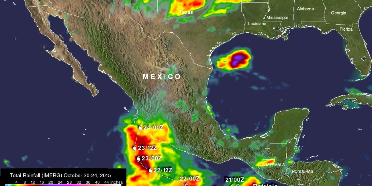
Data from NASA's Integrated Multi-satellitE Retrievals for GPM (IMERG) were used to estimate the amount of rain that fell during the short time period when hurricane Patricia explosively developed and circled back to hit Mexico. This analysis included data collected from October 20-24, 2015 and shows rainfall for the East Pacific, Mexico and the surrounding region. This preliminary rainfall total analysis shows that thus far the heaviest rain from Patricia fell over the open waters of the Eastern Pacific. Rainfall totals there were found to be over 409 mm (16.1 inches). An even rainfall greater total, that was not associated with Patricia, was located in the Gulf Of Mexico where over 507 mm (almost 20 inches) of rain fell during this short period. Rain totals of over 203 mm (8 inches) were located where Patrica made landfall.
Hurricane Patricia made history early Friday morning, when it became the strongest storm ever recorded in the Western Hemisphere with maximum sustained winds reported at 200 mph by the National Hurricane Center (NHC) at 4:00 am CDT October 23rd based on Hurricane Hunter aircraft measurements collected in the eye of the storm. Its estimated minimum central pressure of 880 mb was also the lowest ever recorded in the Western Hemisphere, besting Hurricane Wilma's 882 mb in 2005 and Hurricane Gilbert's 888 mb in 1988; those storms both had maximum sustained winds of 185 mph. For comparison, Hurricane Katrina, the costliest storm in US history, had a minimum central pressure of 902 mb and peak sustained winds of 175 mph while Supertyphoon Haiyan, which devastated the central Philippines in 2013, had peak sustained winds of 195 mph, but those were estimated from satellite and thus less precise. The lowest pressure ever recorded in a tropical cyclone was 870 mb in Typhoon Tip west of Guam in the western Pacific back in 1979. Its maximum sustained winds were measured by aircraft at 190 mph.
Not only is Patricia historic in terms of its overall intensity, it is also one of the fastest strengthening storms on recored. At 4:00 am CDT on the morning of Thursday the 22nd, Patricia was a run-of-the-mill Category 1 hurricane with a minimum central pressure of 980 mb and maximum sustained winds of 85 mph. Twenty-four hours later at 4:00 am CDT on the 23rd, after undergoing what is known as a rapid intensification cycle, the pressure had fallen 100 mb to 880 mb, and the peak sustained winds had increased by 115 mph to 200 mph. This rate of wind intensification supercedes the previous record rate in the eastern Pacific of ~100 mph (85 knots) in 24 hours set by Hurricane Linda back in 1997, which was until Patricia the strongest hurricane on record in the East Pacific, and Wilma's increase of 105 mph in 24 hours in the western Caribbean. Patricia's 100 mb pressure fall in 24 hours well exceeds Linda's 81 mb in 24 hours and just exceeds Hurricane Wilma's 97 mb fall in 24 hours.
Such rapid intensification indicates that the environmental conditions for the storm are ideal, namely very little wind shear, no dry air intruding into the storm, and warm sea surface temperatures, in this case very warm sea surface temperatures, which provide the fuel for such storms. The current 2015 El Nino is setting up to be one of the strongest on record. As a result, sea surface temperatures are well above average over a vast area of the Equatorial East Pacific. However, El Nino is not the only story. For about the past two years, "the Blob" has also been lurking along the West Coast of North America. This large mass of above-normal sea surface temperatures extends from the Bering Sea all the way down to the Pacifi Coast of Mexico and is likely part of the Pacific-Decadal Oscillation, akin to the El Nino/Southern Oscillation or ENSO, it goes through warm and cold phases. The PDO is currently in a warm phase, which is manifest by above-normal sea surface temperatures along the Pacific Coast of North America. The juxtaposition of these two large masses of warm water has contributed to the ideal conditions for the development and rapid intensification of Hurricane Patricia southwest of Mexico.
GPM is a joint mission between NASA and the Japanese space agency JAXA.
Images produced by Hal Pierce (SSAI/NASA GSFC) and caption by Steve Lang (SSAI/NASA GSFC) and Hal Pierce.