Mexico

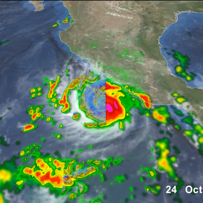
GPM Overpass of Hurricane Otis
After rapidly intensifying overnight, Hurricane Otis made landfall near Acapulco, Mexico around 1:25 a.m. CDT (06:25 UTC) on Wednesday Oct. 25 as a powerful Category 5 hurricane. Otis had maximum sustained winds estimated at 165 mph by the National Hurricane Center (NHC), making it the first Category 5 as well as the most powerful storm to hit the Pacific coast of Mexico on record. Otis formed into a tropical depression (TD 18-E) on the morning of Sunday Oct. 22 about 530 miles (850 km) south-southeast of Acapulco from a broad area of low pressure. The depression was moving slowly northward

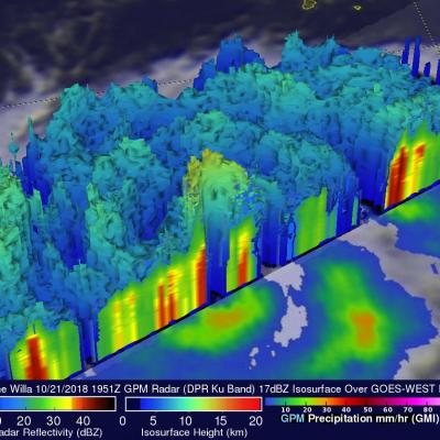
Dangerous Hurricane Willa Probed By GPM Satellite

Hurricane Willa was moving northward toward the western coast of Mexico when the GPM core observatory passed above on October 21, 2018 at 1:51 PM MDT (1951 UTC). The hurricane had maximum sustained winds of about 95 mph (109 kts). Since then Willa has rapidly intensified and today has winds of 155 mph (135 kts) making it a dangerous category four on the Saffir-Simpson hurricane wind scale. GPM's Microwave Imager (GMI) and Dual-Frequency Precipitation Radar (DPR) instruments collected data showing that hurricane Willa and feeder bands were producing heavy rainfall over a large area. The

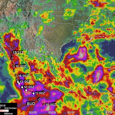
Hurricane Bud's Rainfall Measured with GPM IMERG

Beneficial rainfall from hurricane Bud's remnants has spread into the Desert Southwest. This rainfall may be helpful in an area that has been experiencing exceptional drought accompanied by wildfires. Bud's rainfall may also signal the beginning of the summer monsoon over the Desert Southwest. The image above shows estimates of accumulated rainfall using IMERG (Integrated Multi-satellitE Retrievals for GPM) data generated during the period from June 9-18, 2018. This rainfall occurred during the period when Bud formed southwest of Mexico, intensified into a powerful category four hurricane

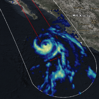
GPM Flies Over Hurricane Bud off the Coast of Mexico

View full-screen in STORM Event Viewer The GPM core observatory satellite passed above hurricane BUD in the eastern Pacific Ocean on June 12, 2018 at 5:27 PM MDT (2327 UTC). BUD's movement over colder waters had caused it's eye to become less defined. Data collected by GPM's Microwave Imager (GMI) showed that moderate to heavy precipitation was only present in the southeastern quadrant of the weakening hurricane. GPM's GMI also indicated that the heaviest rainfall in the area, of over 78 mm (3.1 inches) per hour, was occurring near Mexico's coastline well to the northeast of BUD's center of

Tropical Storm Aletta Forms In Eastern Pacific

Early today Tropical Depression Two-E was upgraded to tropical storm Aletta. This is the first tropical storm of the 2018 eastern North Pacific season. Aletta was located well southwest of Mexico. The National Hurricane Center (NHC) predicts that Aletta will become a hurricane tomorrow as it moves westward over the open waters of the eastern North Pacific ocean. The GPM core observatory satellite passed above developing tropical storm Aletta on June 6, 2018 at 0046 UTC. This image shows precipitation measurements that were calculated from data collected by GPM's Microwave Imager (GMI) and Dual

GPM Sees Hurricane Max Approaching Mexico's Coast

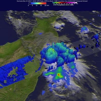
Hurricane Max made landfall on Mexico's southern Pacific coast yesterday afternoon. Max was a small hurricane with maximum sustained winds of about 86 mph (75 kts). By this morning wind speeds in the dissipating storm had decreased to about 29 mph (25 kts). Max's dissipating remnants are still expected to produce heavy rain as they continue moving eastward today. The GPM core observatory satellite passed above Hurricane Max on September 14, 2017 at 11:35 AM CDT (1653 UTC) as Max was close to making landfall east of Acapulco, Mexico. Although Max was a small hurricane the GPM satellite's radar

Deadly Hurricane Earl's Rainfall Measured With IMERG

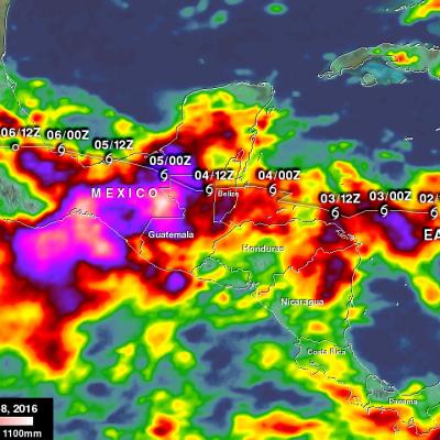
Hurricane Earl began as a tropical wave that was tracked by the National Hurricane Surface (NHC) from the African Coast to the Caribbean Sea. The tropical wave drenched the Dominican Republic where it was blamed for the deaths of six people. Southwest of Jamaica on August 2, 2016 the tropical wave developed a closed circulation and Earl was upgraded to a tropical storm. On Wednesday August 3, 2016 Earl became a hurricane when it was located about 150 miles east of Belize. On Thursday Earl made landfall just southwest of Belize City, Belize at about 0600 UTC (2 AM EDT). At landfall Earl had

GPM Sights Another Forming Tropical Cyclone

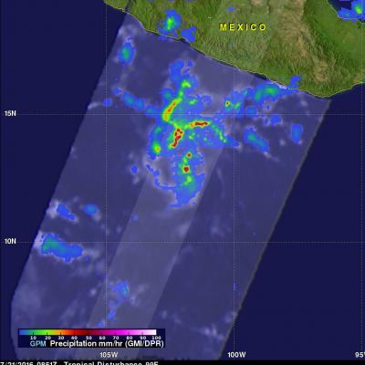
The eastern Pacific Ocean continues to spawn tropical cyclones. Seven named tropical cyclones have already formed in the Eastern Pacific ocean this year. The National Hurricane Center (NHC) has indicated that another tropical cyclone is likely to form in a broad area of low pressure southwest of Acapulco, Mexico. The GPM core observatory satellite flew directly above this increasingly organized stormy area on July 21, 2016 at 0851Z. GPM found that powerful thunderstorms in that area contained intense showers. Rain was measured by GPM's Dual-Frequency Precipitation Radar (DPR) instrument

Forming Tropical Storm Darby Analyzed By GPM

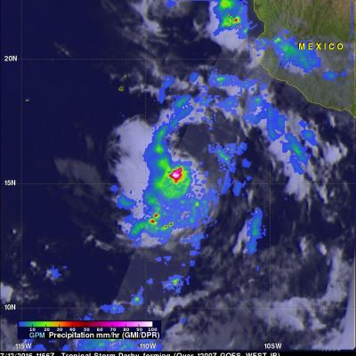
Tropical storm Darby became the fourth eastern Pacific Ocean tropical storm to form on July 12, 2016. Last year was an El Nino year and this year is transitioning to a La Nina year with cooler sea surface temperatures (SST) expanding across the eastern equatorial Pacific Ocean. Fewer tropical storms are normally expected to develop in the eastern Pacific Ocean during La Nina years but so far this year tropical cyclones are forming in the eastern Pacific Ocean at about the same pace as last year. The GPM core observatory satellite flew above tropical depression five (TD05E) on July 12, 2016 at

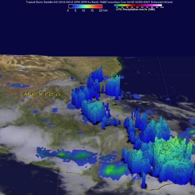
Danielle Hits Mexico And Weakens

Tropical Storm Danielle started weakening after making landfall north of Tuxpan, Mexico on Monday evening just before June 21, 2016 at 0000 UTC (June 20, 2016 7:00 PM CDT). As Danielle weakened the low level circulation quickly became disorganized. The GPM core observatory satellite passed above rapidly weakening Danielle on June 21, 2016 at 0421Z (June 20, 2016 11:21 PM CDT). The approximate center of Danielle's circulation at the time of this GPM pass is shown with a red tropical storm symbol. A rainfall analysis from GPM's Microwave Imager (GMI) and Dual-Frequency Precipitation Radar (DPR)