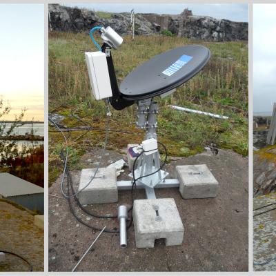
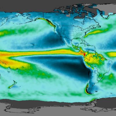
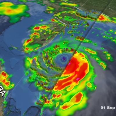
Articles

Farmers looking at an App
Unexpected shocks from natural hazards can affect populations throughout the globe, threatening sustainable development and resilience. However, the impacts of these events, such as extreme precipitation or drought, disproportionately affect the developing world where individuals often are not insured and live and work in conditions that leave them vulnerable to natural disasters. This can lead to significant economic and environmental challenges if preventive measures or mitigating measures are not taken in time. To reduce risks from natural disasters and build climate resilience, decision...
Field in Pakistan
Download this video from the NASA Goddard Scientific Visualization Studio Today, India is among the world’s most water-scarce countries. This means that it does not have enough freshwater resources to meet the needs of all the people who live there. Mismanagement of water resources have largely contributed to the country’s limited water supplies. A growing competition over finite water resources will have serious implications for Indian farmers, as well as India’s food security. More than 70% of India’s population rely on agriculture as a source of livelihood. Even more so, an estimated 82% of...
JAXA DPR Logo
One of the prime instruments onboard the GPM Core Observatory is the Dual-frequency Precipitation Radar (DPR). The DPR consists of a Ku-band precipitation radar (KuPR) and a Ka-band precipitation radar (KaPR). The KuPR, which operates at 13.6 GHz, is an updated version of the highly successful unit flown on the Tropical Rainfall Measuring Mission (TRMM). The KuPR and the KaPR are co-aligned on the GPM spacecraft bus such that the 5-km footprint location on the earth is the same.
GMI in Electromagnetic Interference Testing
The Global Precipitation Measurement (GPM) Microwave Imager (GMI) instrument is a multi-channel, conical- scanning, microwave radiometer serving an essential role in the near-global-coverage and frequent-revisit-time requirements of GPM. The instrumentation enables the Core spacecraft to serve as both a precipitation standard and as a radiometric standard for the other GPM constellation members. The GMI is characterized by thirteen microwave channels ranging in frequency from 10 GHz to 183 GHz. In addition to carrying channels similar to those on the Tropical Rainfall Measuring Mission (TRMM) Microwave Imager (TMI), the GMI carries four high frequency, millimeter-wave, channels near 166 GHz and 183 GHz. With a 1.2 m diameter antenna, the GMI provides significantly improved spatial resolution over TMI.
GPM Overpass of Cyclone Harold from April 6th, 2020
Video credit: Greg Shirah, Kel Elkins, Alex Kekesi (NASA Goddard Scientific Visualization Studio). For more information or to download this public domain video, go to: https://svs.gsfc.nasa.gov/4812#29226 A Category 4 cyclone, the most powerful yet of 2020, made landfall on the South Pacific nation of Vanuatu on Monday, not long before this GPM overpass from April 6th, 2020 at 1:41 UTC. Tropical Cyclone Harold developed from a low pressure system that was observed to the east of Papua New Guinea last week, and has tracked to the southeast, where it has already caused flooding and loss of life...