Articles

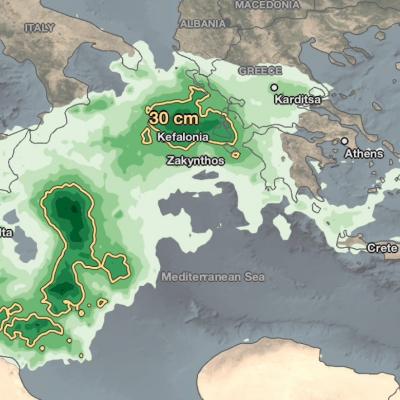
IMERG Rainfall Totals from Medicane Ianos
From September 14th - 20th, 2020, NASA’s IMERG algorithm estimated the rainfall from a Mediterranean cyclone with tropical-like characteristics, commonly known as a “Medicane”, which flooded parts of Greece. Medicanes typically appear once or twice a year and are similar to tropical storms in that both have a symmetric structure, a warm core, a clearly visible eye, and winds of at least tropical-storm strength. This particular storm system, dubbed "Ianos" by the National Observatory of Athens, led to media reports of flooding throughout the islands of Kefalonia and Zakynthos off the western

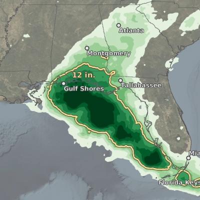
IMERG totals from hurricane sally
The northern Gulf Coast has seen its share of storms this busy hurricane season. At the end of August, then Tropical Storm Marco brought heavy rains to parts of the Florida Panhandle while western Louisiana took a direct hit from the much more powerful Category 4 Hurricane Laura. Now, just over 3 weeks since Laura made landfall, the northern Gulf Coast was struck again, this time by Hurricane Sally. Though not as powerful as Laura, the still rather strong Sally behaved more like Marco. But, while Marco was largely sheared apart with most of the rain well northeast of the center as it slowed
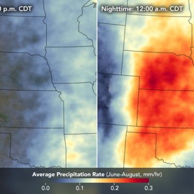
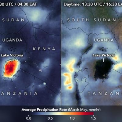
Maps showing the Average Precipitation Rate in Lake Victoria, Africa - Day vs. Night
Lake Victoria is the largest lake in Africa and an economic and food security lifeline for roughly 30 million people living near its shores in Uganda, Kenya, and Tanzania. But it also takes lives. Cyclical, daily weather patterns around the lake create violent nighttime thunderstorms that kill roughly 3,000 to 5,000 fishermen per year. “This is definitely one of the stormiest places on Earth,” said Wim Thiery, a climate scientist at the Vrije Universiteit Brussel who has studied Lake Victoria for several years. “Almost every night, you see these intense thunderstorms and sometimes even water
IMERG Rainfall from Typhoons Bavi, Maysak and Haishen
From August 22 through September 7, 2020, NASA’s IMERG algorithm estimated rainfall from three typhoons as they passed over the Pacific Ocean, Japan, and Korea. According to NOAA's records, this was the only time since records have been kept starting in 1945 that the Korean peninsula saw three landfalling typhoons in a single year, let alone in two weeks. Each of the three typhoons--Bavi, Maysak, and Haishen--reached the equivalent of “major hurricane” status, meaning Category 3 or above on the Saffir-Simpson hurricane-intensity scale (shown here as a red in the hurricane track) along their
IMERG Grand Average Climatology 2001 - 2019
A new data product merges data from the Tropical Rainfall Measuring Mission (TRMM) and the Global Precipitation Measurement (GPM) mission, giving meteorologists and researchers access to a 20-year precipitation record. How much rain and snow fall on Earth in any given year? NASA scientists are answering this question more accurately than ever before and observing precipitation in the most remote places on Earth. And it’s all thanks to an international constellation of satellites. At any given time, instruments onboard about a dozen satellites contribute to a record of the world’s rain and snow